Colorado Trail: Little Molas Lake to Lime Creek 
Distance: 7.4 - 10.1 miles (round trip)
San Juan National Forest, near Silverton in Southwest Colorado
A moderately easy hike along a segment of the Colorado Trail featuring panoramic views from the high meadows above the West Lime Creek valley.
See Trail Detail/Full Description
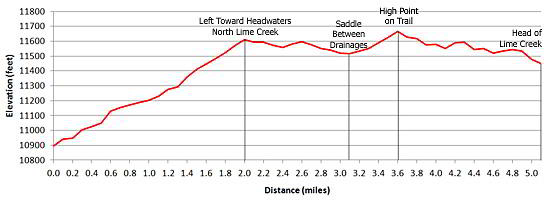
- Distance: 10.1 miles (round trip) to Lime Creek
- Elevation: 10,895-ft. at Trailhead
11,650-ft. at Lime Creek - Elevation Gain: 755-ft. to Lime Creek
- Difficulty: moderate
- More Hikes in:
Silverton / Ouray / Southwest Colorado
Why Hike Colorado Trail: Little Molas Lake to Lime Creek
This relatively easy walk gives day hikers a scenic taste of the Colorado Trail, an epic 471-mile route stretching between Denver and Durango. The out-and-back hike follows a 5.0-mile segment of the trail, traversing pretty meadows with panoramic views high above the Lime Creek Drainage.
The hike is located just north of Molas Pass (10,910-ft.) in the area of the 1879 Lime Creek Burn that incinerated 26,000-acres of forest. The fire burned with such intensity that the forest has still not recovered.
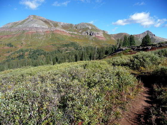
Vast meadows, sprinkled with replanted lodgepole pines, now cover the area once blanketed with thick forest, offering far reaching vistas of the Grenadier Range to the east, the West Needle Mountains and Engineer Peak to the south and Twin Sisters to the west. West Turkshead Peak dominates the skyline to the north.
Elevation Profile

Buy the BookThis opinionated guide includes all the hikes in the Ouray, Telluride, Silverton and Lake City sections of the website plus info on local services and nearby attractions. | |
Trail Resources
Trail Detail/Full Description / Trail Photo Gallery / Trail Map
Basecamp(s) Information:
Silverton / Ouray
Region Information:
Southwest Colorado
Other Hiking Regions in:
Colorado

