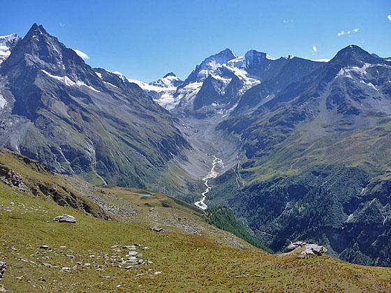
Besso, Pointe de Zinal, Dent Blanche, Grand Cornier and Pigne de la Le from Roc de la Vache
This steep hike leads to Roc de la Vache, a panoramic overlook high above the east side of the Zinal Valley.
See Trail Detail/Full Description
- Distance: 4.1 miles (one way) to Lac d’Arpitetta
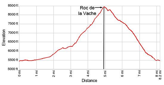
8.2 miles (loop) to Roc de la Vache - Elevation: 5,480-ft. at Trailhead
7,375-ft. at Lac d’Arpitetta
8,468-ft. at Roc de la Vache - Elevation Gain: 1,895-ft. to Lac d’Arpitetta
2,988-ft. to Roc de la Vache - Difficulty: strenuous
- More Hikes in:
Zinal / The Valais
Why Hike Roc de la Vache
A steep hike through varied terrain leads to Roc de la Vache, a popular viewpoint offering a superb perspective of the Zinal area. Starting in Zinal, the trail travels up the Zinal Valley along La Navisence River with fine view of Besso rising to the east. Near the Petite Mountet hut the trail crosses the La Navisence River to the east side of the Zinal valley and then crosses the Torrent de l'Arpitetta to the north side of the Arpitetta Valley.
The path now climbs steeply up the valley's north slopes. Along the way a recommended detour leads to the Lac d'Arpitetta with wonderful views of the cirque at the head of the Arpitetta valley. To the south the high peaks rising along the west side of the Zinal Valley dominate the view.
Beyond the lake the trail ascends steeply up the slopes beneath the Pointe d'Arpitetta to Roc de la Vache. Terrific panoramic views from the overlook extend south to Besso and the Pigne de la Le guarding the entrance to the head of the Zinal valley. The Grand Cornier, Dent Blanche and the Pointe de Zinal, adorn with glaciers, tower above the head of the Zinal valley. The Zinalrothorn, Moming massif and the Moming glacier dominate the view to the southeast while to the east the Tete de Milon and the Pointe d'Arpitetta frame the Weisshorn at the head of the Arpitetta Valley. Zinal lays 3,000-ft. below on the valley floor while to the north views extend up the Val de Anniviers to the Bernese Alps.
Past the viewpoint the trail descends on steep to very steep grades to Zinal accompanied by nice views of the Torrent du Barme and the peaks towering above the west side of Zinal.
The loop can be hiked in either direction. The climb is not quite as steep in the counter-clockwise direction. Another option is to hike to the Roc de la Vache viewpoint after visiting the Cabane Arpitettaz.
Elevation Profile
| Support our Site |
Trail Resources
Trail Detail/Full Description / Trail Photo Gallery / Trail Map
Basecamp(s) Information:
Zinal
Region Information:
The Valais
Other Hiking Regions in:
Switzerland