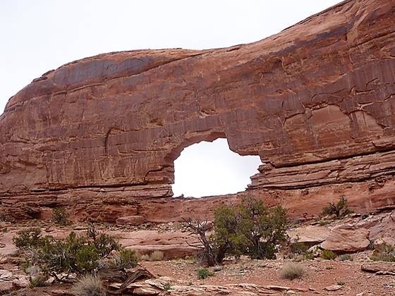
Wonderful views of a stunning canyon, solitude and an impressive jeep-shaped arch more than compensate for the difficulty in following a trail, which is poorly defined in places.
See Trail Detail/Full Description
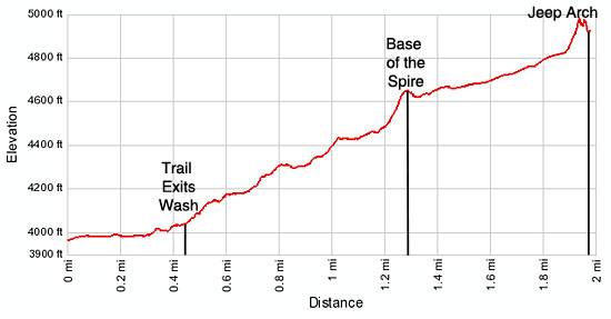
- Distance: 4.0 miles (round trip)
- Elevation: 3,960-ft. at Trailhead
Maximum elevation: 4,975-ft. - Elevation Gain: 1,015-ft.
- Difficulty: moderate
- More Hikes in:
Moab / Southeast Utah
Why Hike Culvert Canyon/Jeep Arch
The trail up beautiful Culvert canyon leads to a photogenic, jeep-shaped arch situated in a large sandstone cul-de-sac. The trail is not always easy to follow and in some spots seems more like a route. Hikers should be comfortable following a cairned trail and need to pay close attention to their surroundings to stay on track.
The reward for the diligence required in following the trail is a hike, with a high degree of solitude, up a scenic canyon to a uniquely shaped arch. The trail, which initially wanders along the canyon bottom, soon climbs to and traverses benches high above the west side of the wash. Wonderful views from the benches encompass the impressive, multihued sandstone walls that line both sides of the canyon and the sinuous routes of the canyon’s many branches cutting through a sea of sandstone terraces, cascading from the Gold Bar Rim, the high ridge to the west of Moab.
The start of the trail is quite unusual, requiring hikers to travels through a huge culvert under railroad tracks. Hikers emerge from the culvert onto a broad, sandy wash. The culvert and the sandy wash are a favorite play spot for local children.
Plan on devoting more time then indicated by the mileage to do this hike. The fine scenery and route finding along a few sections of the trail will slow you down. Outdoor enthusiasts looking for a full day of hiking should have no problem walking the Culvert Canyon trail and the nearby Corona Arch trail in the same day.
This trail is best enjoyed during the spring and fall when temperatures are mild. Hiking is not recommended in the summer when temperatures often exceed 100 degrees F. There is little or no shade along most of the route. Take plenty of water. Do not depend upon finding any water along the route.
Elevation Profile

Trail Resources
Trail Detail/Full Description / Trail Photo Gallery / Trail Map
Basecamp(s) Information:
Moab
Region Information:
Southeast Utah
Other Hiking Regions in:
Utah
