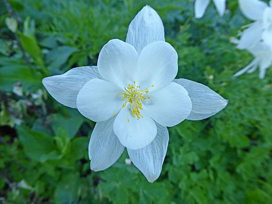
Columbine
This popular, family friendly hike ascends lovely meadows filled with beautiful wildflowers in the pretty Coal Creek Valley. The path leads to Mesquite Divide, a saddle with views of Grand Teton, Rendezvous Peak and the high ridge to the south of Moose Lakes.
- Distance: 5.6 miles (RT)
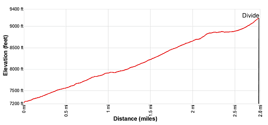
- Elevation: 7,250-ft. at Trailhead
Maximum elevation - 9,197-ft. - Elevation Gain: 1,947-ft.
- Difficulty: moderate
- Basecamp: Jackson / Driggs
- Region: The Tetons
Trail Description - Coal Creek Meadows
This trail is a nice escape from the crowded trails in Teton National Park and a favorite with locals in Jackson area and nearby Victor and Driggs in Idaho. The flowers are at their best in mid to late July.
The Coal Creek Trail begins at the northwest side of the Coal Creek trailhead parking area (see directions below). The path heads northwest and soon crossed Coal Creek on a good bridge. Beyond the bridge the trail curves to the right (north/northeast), ascending on moderate to moderately-steep grades through trees and intermittent meadows above the west side of Coal Creek. At 0.25 miles the path passes into the Jedediah Smith Wilderness Area. In mid to late July (depending on the year) the meadows are filled with beautiful displays of wildflowers.
As the trail proceeds up the valley it curves to the right (east) and then back to the left (northeast), echoing the creek’s course along the valley floor. At 0.9 miles the trees thin and soon give way to Coal Creek meadows scattered with clusters of willows.
At 1.2 miles the path crosses to the east side of the creek and then ascends on moderate-steep to steep grades up slopes filled with wildflowers. Two switchbacks facilitate the climb up the lush slopes along the east side of the valley. As the trail gains elevation views open to Taylor Mountain, towering above the west side of the valley, and the rolling, forested hills to the south. Soon groves of aspens and patches of sage appear along the slopes.
At 1.9 miles the path starts passing through clusters of conifers. The grade levels at 2.2 miles as the path curves to the north, traveling through a large, lovely meadow adorn with wildflowers. To the west are fine views of Taylor Mountain’s north ridge.
The trail resumes its climb at 2.5 miles, passing the junction with the trail branching left (west) to Taylor Mountain at 2.6 mile. A trip to Taylor Mountain adds 3.2 miles (round trip) and over 1,300-ft. of elevation gain to the day. See the Taylor Mountain hike for more information.
Beyond the junction the path climbs steep switchbacks to Mesquite Creek Divide, the saddle at the head of the valley, at 2.8 miles. As you crest the divide views open north to Grand Teton and northwest to the summits rimming the ridge to the south of Moose Lakes. Rendezvous Peak rises to the northeast.
The trail continues over the pass, descending along Mesquite Creek to a junction with the Moose Creek trail below Moose Meadows, which eventually connects with the Teton Crest Trail. A trail branching off the Mesquite Creek trail heads northeast to Phillips Pass. Most hikers will be more than satisfied by turning around at Mesquite Divide and retracing their steps back to the trailhead.
Elevation Profile
Driving Directions
From Jackson, WY: From the corner of W. Broadway and Cache Streets, at the southwest corner of the Jackson Town Square, head west Broadway (US-89 S/US-191 S/US-26 W) for 1.4 miles and then turn right onto WY-22 W (Teton Pass Highway). Follow WY-22 W for 13.8 miles. The road crosses Teton Pass at 11.1 miles and then descends for 2.6 miles to the signed Coal Creek Trailhead on the right (north) side of the road. Turn right and park in the Coal Creek Trailhead parking area.
From Driggs, ID: At the only traffic light in Driggs, located at the corner of Main Street (ID-33) and East Little Avenue, head south on Main Street (ID-33 E) for 13.9 miles, crossing the border into Wyoming. Here the road turns into WY-22 E. Continue on WY 22-E for 3.6 miles to the signed Coal Creek Trailhead on the left (north) side of the road. Turn left and park in the Coal Creek Trailhead parking area.
Trail Resources
- Trail Photo Gallery
- Trail Maps
- Basecamp(s) Information: Jackson / Driggs
- Region Information: The Tetons
- Other Hiking Regions in: Wyoming