Breccia Peak 
Distance: 5.5 miles
Teton Wilderness Area, Teton National Forest, near Togwotee Pass in The Tetons
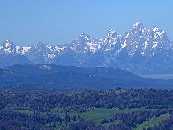
Close-up of the Tetons from Breccia Peak
An unsigned trail leads to a route climbing to Breccia Peak where stunning views encompass the Tetons, the southern Absaroka Mountains and the Wind River Range. Closer at hand are terrific views of the North Breccia Cliffs and the Cub Creek drainage.
- Distance: 5.5 miles (RT)
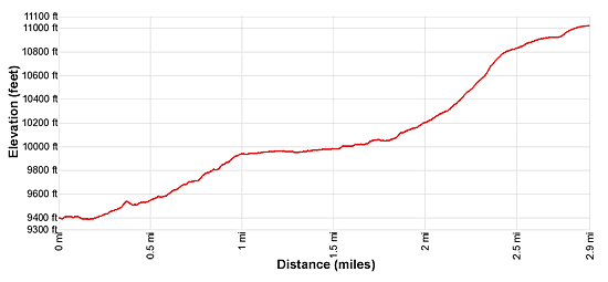
- Elevation: 9,390-ft. at Trailhead
Maximum elevation - 11,010-ft. - Elevation Gain: 1,620-ft.
- Difficulty: killer
- Basecamp: Togwotee Pass / Jackson
- Region: The Tetons
Trail Description - Breccia Peak
Enjoy some solitude on this very steep, nontechnical ascent to Breccia Peak. An established trail to the west of Togwotee Pass leads to beautiful meadows beneath the east facing slopes of Breccia Peak. From here hikers go off trail, ascending north to reach Breccia’s northeast ridge and then climbing very steep grades up the ridge to a high plateau awash in tiny wildflowers beneath the peak.
Cross to the western edge of the plateau for breathtaking views of the entire Teton Range to the southwest, the Gros Ventre Range to the south and the Breccia Cliffs to the north. A short, steep climb soon leads north to the summit of Breccia Peak where views expand to include the southern Absaroka Mountains and the Wind River Range to the southeast.
Note: This hike is situated in the southern Absaroka Range near Togwotee Pass, located to the northeast of Grand Teton National Park. The hike is also easily accessible from Dubois, Wyoming.
The unsigned Breccia Peak trail is located at the northwest end of the pullout along the north side of US 26/US 287 (see trailhead directions below). The path initially heads north, climbing over an embankment along the highway. At 0.1 miles the trail splits. Take the trail to the left which soon crosses a small creek and then curves to the right (northeast), ascending on easy to moderate grades through small meadows and forest. Pine bark beetles have killed a number of the trees in the area.
The trail crosses a creek at 0.25 miles. At 0.4 miles the path emerges from the trees into a small willow-choked meadow, crossing the creek two more times in quick succession. Ahead (north/northwest) are our first view of Breccia Peak.
Beyond the crossings the trail continues its ascent through meadows and cluster of trees. Open areas offer more nice views of Breccia Peak. Two Ocean Mountain rises above the Togwotee Pass area to the south.
At 0.9 miles the path curves to the left (northwest), ascending through pretty meadows and scattered trees. At 1.0 mile the ascent ends and the path now travels on easy grades, curving to the right (north) at 1.25 miles. Soon the trail reaches a meadow-clad valley (~10,000-ft.) beneath the east facing slopes of Breccia Peak. Continue along the trail as it ascends gently up the east side of the valley, staying to the right (east) of a stream meandering down the valley floor. During the height of the summer the meadows are awash in wildflowers.
At this point stop and look at Breccia Peak. Note the prominent cliff band along the east facing slopes. Our goal is to ascend Breccia Peak’s northeast ridge, skirting the right (north) end of the cliffs and then ascend the northeast ridge. Some hikers climb up the left (south) end of the cliffs, which requires some scrambling, and then ascend Breccia Peak’s south ridge. I recommend northeast ridge.
The trail soon fades away. Continue up the east side of the meadow. Ahead you will see a row of signs marking the boundary of the Teton Wilderness area. Beyond the signs, ascend off-trail north across the meadows toward the northeast ridge. Views soon open northeast to the ridge rising above Cub Creek.
At about 1.8 miles climb due north on moderate-steep to steep grades, angling up the peak’s east facing slopes. As you climb you will need to work your way across drainages and skirt clusters of trees. When you reach to northeast ridge (~2.0 miles), curve to the left (west) and climb very steep grades up the ridge through grassy meadows. At times you will want to skirt rock outcroppings and small fields of scree to stay on the grass. Along the way enjoy ever improving views of the ridge rising to the east and the Cub Creek Valley and summits towering above the South Fork of Buffalo Creek to the northeast. As you near the edge of the ridge terrific views open north/northwest to the North Breccia Cliffs.
At 2.4 miles the grade abates as you reach a high plateau sprinkles with tiny wildflowers. Continue ascending west along the northeast ridge on moderate grades accompanied by fine views of the rugged ridge between Breccia Peak and the North Breccia Cliffs. Thorofare Mountain and Younts Peak grace the skyline to the northeast in the Absaroka Range.
Soon the edge of the plateau curves to the right, rising to Breccia Peak. My advice is to keep walking in the westerly direction to the western end of the plateau at 2.8 miles. Here stunning views open west to the Tetons. The North Breccia Cliffs dominate the view to the north while the peaks of the Gros Ventre Range fill the horizon to the south. Lost Lake is nestled in the tree lined bowl beneath Breccia Peak’s west facing slopes.
To officially bag Breccia Peak, turn right and ascend on moderately-steep to steep grades up the south ridge to the summit (11,010-ft.) at 2.9 miles. Here we enjoy more great views that now also encompass the southern Absaroka Mountains and the Wind River Range to the southeast.
When you are done enjoying the views retrace your steps to the trailhead. A trekking pole comes in handy when descending the very steep slopes along the northeast ridge.
Elevation Profile
Driving Directions
From Dubois: From the corner of N 1st Street and US 26 in Dubois, drive 32.2 miles west/northwest on US 26/US 287 to a large pullout on the right (north) side of the highway. The drive will pass the turnoff for the Brooks Lake Recreation area at 30.9 miles. Drive 1.3 miles further, going over Togwotee Pass, and then look for the large pullout before the road curves to the left (west). (There are no signs.) The obvious trail is located on the northwest end of the pullout where it climbs steeply up an embankment.
From Jackson: From the corner of W. Broadway and Cache Streets, at the southwest corner of the Jackson Town Square, head north on N Cache Street (US 191 N/US 89 N/ US 26 E) for 30.1 miles to Moran Junction. Here US 191/US 89 turn left toward the Jackson Lake area of Grand Teton National Park and Yellowstone. We bear right (east) on the continuation of US 26 E/ US 287 toward Dubois.
Drive east for 24.5 miles. Across the road you will see a large pull off. Drive 0.1 mile further to a large pullout located on the right (south) side of the road. You can park here, carefully cross the highway and then walk west along the shoulder to the large pullout on the right (north) side of the road where your will find the trail. Alternatively, carefully use the pullout to turn around and head west on the highway, parking at the pullout on the north side of the highway. The obvious trail is located on the north side of the road (at the northwest end of the large pullout) where it climbs steeply up an embankment.
Note: The pullout and trailhead for Breccia Peak are located before (on the west side) of Togwotee Pass the turnoff for the Brooks Lake Recreation Area. If you miss the pullout, carefully turn around at Togwotee Pass or the Brooks Lake Road and head west to the pullout on the right (north) side of the highway.
Trail Resources
- Trail Photo Gallery
- Trail Maps
- Basecamp(s) Information: Togwotee Pass / Jackson
- Region Information: The Tetons
- Other Hiking Regions in: Wyoming