Details: Nigel Pass 
Distance: 9.8 miles (round trip)
Banff National Park, near Banff in The Canadian Rockies
Hike Facts
- Distance: 9.8 miles (round trip)
- Elevation: 6,160-ft. - 7,200-ft.
- Elevation Gain: 1,040-ft.
- Difficulty: easy-moderate
- Trail Highlights: See Trail Intro
- Basecamp(s): Banff / Lake Louise
- Region: The Canadian Rockies
This moderately-easy trail ascends the scenic Nigel Creek valley to Nigel Pass (7,200-ft.) and a panoramic ridge with awesome views of Nigel Peak, the Brazeau River Valley and the high peaks rising beyond Parker Ridge at the northern end of Banff National Park.
Trailhead to Nigel Pass
The trailhead to Nigel Pass is located along the east side of the Icefield Parkway, a short distance to the north of the Big Bend, a long switchback, and the Bridal Veil Falls Viewpoint. (See driving directions below.)
From the trailhead at the northwest end of the parking area, follow the broad gravel path, part of the old Banff to Jasper road, northwest. (Note: Older trail descriptions and maps show the trail crossing Nigel Creek on a bridge near the trailhead. This bridge has been washed away making it necessary to walk along the road on the alternate route.) Ahead Nigel Peak SE3 (9,925-ft.) rises above the trees along the west side of the valley. This sub-peak of nearby Nigel Peak is named for being 3-kilometers southeast of its parent peak.
At 1.1 miles turn right (north) on the marked trail that travels through spruce-fir forest, passing a warden station and the former site of Camp Parker at 1.25 miles. Beyond the camp continue through trees to a crossing of Hilda Creek on a wood plank bridge at 1.4 miles.
On the north side of the bridge the trail curves to the right (northeast) and wanders through a small meadow with views of Nigel SE3. Turn around to see Mount Athabasca (11,453-ft.) and Hilda Peak (10,052-ft.) rising above to the west side of the Icefield Parkway.
Soon the trail crosses a second plank bridge over Nigel Creek at 1.5 miles. The path now heads north up the east side of the Nigel Creek Valley, ascending through forest on easy to moderate grades. Openings in the trees offer nice views of Nigel Peak SE3 along with the peaks rising to the west across the Parkway. Parker Ridge is seen to the south of Mount Athabasca.
Views improve at 2.3 miles as the trail begins a traverse through meadows scattered with small conifers and willow thickets along the base of a broad avalanche chute. To the north, Peak 9,951 is now visible, towering above the head of the valley. Rock-hop across the stream descending the chute at 2.5 miles and then reenter the trees.
The trail continues its ascent up the east side of the valley, traveling through scattered trees interspersed with meadows clears by avalanches tumbling down the steep slopes above the trail. Depending on the time of year, a few streams carrying meltwater trickle down the slopes.
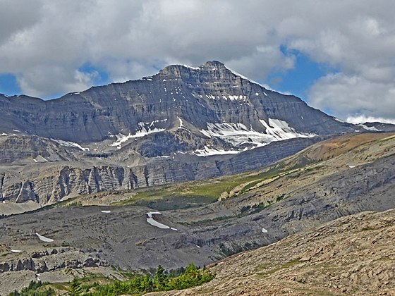
As you gain elevation views open to Nigel Pass, located along low ridge spanning the head of the valley. To the right (east) of the pass are the impressive, sheer cliffs extending along the west ridge of Peak 9,819. An unnamed peak rises to the west beyond the pass. Turn around for views of Big Bend Peak (9,199-ft.) and Mount Saskatchewan (10,964-ft.) rising beyond Parker Ridge to the south. Below the trail the braid channels of Nigel Creek wind down the gravel flats along the valley floor. At 3.9 miles views open to Nigel Peak (10,535-ft.), towering above a side valley to the west.
The final short, moderately steep climb to the pass gains over 380-ft. in half a mile. The trail initially ascends through scattered conifers and then alpine meadows to reach Nigel Pass at 4.9 miles. Cairns mark the spot on the border of Banff and Jasper National Parks. The pass itself is somewhat anticlimactic, with nice views of the Brazeau River, flowing down the valley at the foot of the pass. Ahead are the impressive cliffs along the western ridge of Peak 9,819.
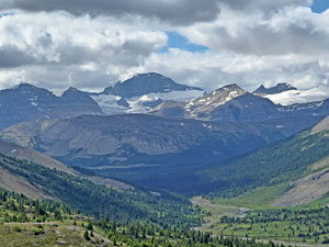
For the best views, climb the ridge above the pass. Various use trails lead to the ridgetop. Here views open east toward the head of the Brazeau River Valley, Cataract Pass and the high peaks rising beyond the pass. To the north are fine views of the peak soaring above the Brazeau River Valley. If you look carefully, you should be able to spot the trail climbing Four Point Creek toward Jonas Pass, part of the Brazeau Loop backpack. Nigel Peak, its southeast ridge and SE3 fill the skyline to the west while Mount Saskatchewan dominates the view to the south, towering above a sea of peaks beyond Parker Ridge.
After taking in the view, day hikers should reverse course, retracing their steps back to the parking lot.
Backpacking Options:
This hike is the first segment of the popular 4-5 day Brazeau Loop backpack. From the ridge, the trail continues over pass, crosses the Brazeau River and then heads down the Brazeau River Valley, connecting with the Jonas Pass and Poboktan Pass trails.
Alternatively, follow the Nigel Pass trail across the Brazeau River and then turn right (east), ascending to Cataract Pass. The pass marks the boundary of Jasper National Park and the White Goat Wilderness. Beyond the pass is the trailless route leading to Cline Pass and beyond, an area for experienced backpackers adept with route finding. Backpacking permits are required for all overnight trips and can be reserved ahead of time. See the Banff and Jasper National Park sites for more information.
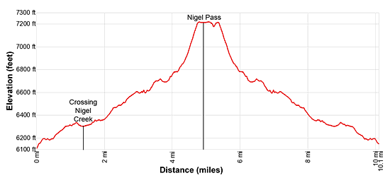
Elevation Profile
Driving Directions
From Lake Louise, AB Canada: Head north on the Trans-Canada Highway AB-1 N for 1.5 miles and then take the Icefields Parkway (AB-93 N) exit toward Jasper and Rocky Mountain House. Follow AB-93 for 70.2 miles and turn right into the Nigel Pass parking area, located on the east side of the Icefield Parkway. The turn is just beyond the Big Bend, a long switchback, and the Bridal Veil Falls Viewpoint along the Icefield Parkway.
From Banff, AB Canada: Head north on the Trans-Canada Highway AB-1 N for 36 miles and then take the Icefields Parkway (AB-93 N) exit toward Jasper and Rocky Mountain House. Follow AB-93 for 70.2 miles and turn right into the Nigel Pass parking area, located on the east side of the Icefield Parkway. The turn is just beyond the Big Bend, a long switchback, and the Bridal Veil Falls Viewpoint along the Icefield Parkway.
From Field, BC Canada: Head east on the Trans-Canada Highway (BC-1 E), which turns into AB-1 when it crosses the border into Alberta, for 14.2 miles and then take the Icefields Parkway (AB-93 N) exit toward Jasper and Rocky Mountain House
Follow AB-93 for 70.2 miles and turn right into the Nigel Pass parking area, located on the east side of the Icefield Parkway. The turn is just beyond the Big Bend, a long switchback, and the Bridal Veil Falls Viewpoint along the Icefield Parkway.
From Jasper, AB Canada Drive south on the Icefields Parkway (AB-93 S) for 70.8 miles and turn left into the Nigel Pass parking area, located on the east side of the Icefield Parkway. You missed the turn if you pass the Bridal Veil Falls Viewpoint and the Big Bend, a long switchback, along the Icefield Parkway.
Trail Resources
Trail Intro / Trail Photo Gallery / Trail Map
Basecamp(s) Information:
Banff / Lake Louise
Region Information:
The Canadian Rockies
Other Hiking Regions in:
Alberta / British Columbia