Thomas Lakes 
Distance: 8.2 miles (round trip)
Maroon Bells-Snowmass Wilderness, White River National Forest, near Aspen in Central Colorado
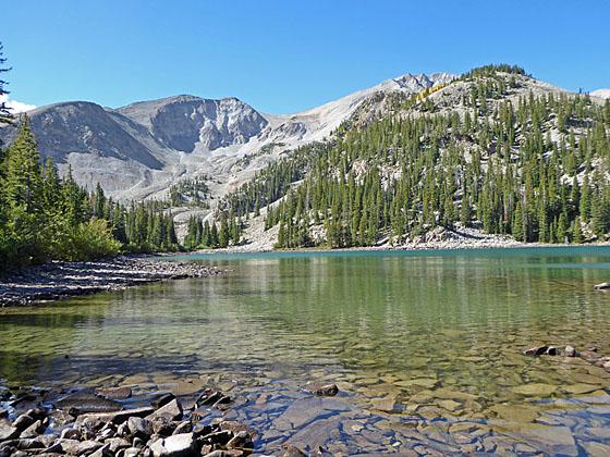
A nice hike to two pretty lakes cradled beneath the twin-summits of Mt. Sopris. Beyond the lakes the trail climbs steeply to the eastern summit of Mt. Sopris.
See Trail Detail/Full Description
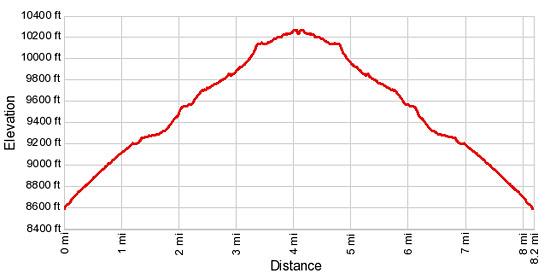
- Distance: 8.2 miles (round trip) to Thomas Lakes
- Elevation: 8,656-ft. at Trailhead
10,288-ft. at Thomas Lakes - Elevation Gain: 1,632-ft. to Thomas Lakes
- Difficulty: moderate
- More Hikes in:
Aspen / Central Colorado
Why Hike Thomas Lakes
Mt Sopris stands alone at the northwest end of the Elk Range, rising almost 6,400-ft above the surrounding valleys to the south of Carbondale and west of Aspen. This pleasant hike climbs to the timber lined shores of the Thomas Lakes, nestled beneath the mountain’s rugged northeast face.
The trail starts with a moderate climb up an old jeep road and then follows a trail ascending through meadows and forest to the two lakes. Along the way views extend over wooded hills to the high peaks of the Elk Range rising to the east and the Roaring Fork Valley to the north.
The trail is popular with hikers looking for a relatively easy day hike and backpacker seeking to summit Mt. Sopris. Many people backpack to the Thomas Lakes and spend the night before climbing to the summit on the second day. The trail is also a good option for people wishing to acclimatize or if bad weather precludes hiking the higher trails to the east.
Elevation Profile

Buy the BookThis opinionated guide includes all the hikes in the Aspen, Buena Vista, Crested Butte, Marble and Leadville sections of the website plus info on local services and nearby attractions. | |
Trail Resources
Trail Detail/Full Description / Trail Photo Gallery / Trail Map
Basecamp(s) Information:
Aspen
Region Information:
Central Colorado
Other Hiking Regions in:
Colorado

