Cataract Lake 
Distance: 4.2 - 10.0 miles (round trip)
Gunnison BLM, near Lake City in Southwest Colorado
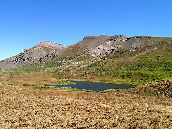
Looking down at Cataract Lake from near the Continental Divide
Beginning in dense woods the trail passes cascades and waterfalls along Cataract Creek, travels through beautiful alpine meadows and visits a scenic alpine lake on its way to the Continental Divide
See Trail Detail/Full Description
- Distance: 10.0 miles (round trip)
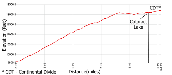
- Elevation: 9,630-ft. at Trailhead
Maximum elevation: 12,200-ft. - Elevation Gain: 2,570-ft.
- Difficulty: moderate-strenuous
- More Hikes in:
Lake City / Southwest Colorado
Why Hike Cataract Lake
This scenic hike ascends steeply up Cataract Gulch to a pretty lake basin and then climbs to the Continental Divide Trail (CDT). Along the way the trail travels through dense woods, passes numerous cascades and waterfalls along Cataract Creek and wanders through lovely alpine meadows. Extend the hike by following a section of the CDT toward Cuba Gulch.
Elevation Profile
| Buy the BookThis opinionated guide includes all the hikes in the Ouray, Telluride, Silverton and Lake City sections of the website plus info on local services and nearby attractions. |
Trail Resources
Trail Detail/Full Description / Trail Photo Gallery / Trail Map
Basecamp(s) Information:
Lake City
Region Information:
Southwest Colorado
Other Hiking Regions in:
Colorado