Bridge of Heaven (via the Horsethief Trail) 
Distance: 8.0 miles (round trip)
Uncompahgre National Forest, near Ouray in Southwest Colorado
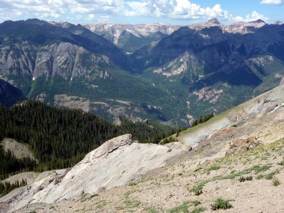
Yankee Boy Basin and the Mt. Sneffels Range from the Bridge of Heaven
A well-engineered 3,000-ft ascent to a knife-edge ridge with spectacular panoramic views.
See Trail Detail/Full Description
- Distance: 8.0 miles (round trip) to Bridge of Heaven
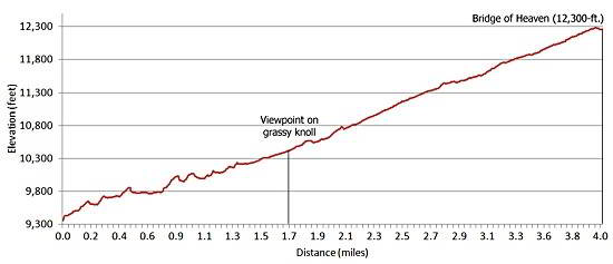
- Elevation: 9,300-ft. at Trailhead
12,300-ft. at Bridge of Heaven - Elevation Gain: 3,000-ft. to Bridge of Heaven
- Difficulty: strenuous
- More Hikes in:
Ouray / Southwest Colorado
Why Hike Bridge of Heaven (via the Horsethief Trail)
Choose a promising day and take a walk to heaven. The aptly named Bridge of Heaven trail leads to a lofty vantage point on a narrow 12,300-ft. ridge with spectacular, panoramic views of the Cimarron Range to the northeast, the Sneffels Range to the west and Ironton and Red Mountain Pass to the south.
Getting to heaven takes some effort. The trail ascends 3,000-ft. in 4.0 miles. Thankfully a well-engineered trail makes the climb easier that it sounds. Trailhead access is another issue. Four-wheel drive is required to cross Dexter Creek and negotiate the final 2.2 miles of rough road ascending 700-ft. to the trailhead parking area.
Elevation Profile
| Buy the BookThis opinionated guide includes all the hikes in the Ouray, Telluride, Silverton and Lake City sections of the website plus info on local services and nearby attractions. |

Trail Resources
Trail Detail/Full Description / Trail Photo Gallery / Trail Map
Basecamp(s) Information:
Ouray
Region Information:
Southwest Colorado
Other Hiking Regions in:
Colorado