Wetterhorn Basin 
Distance: 5.8 - 9.0 miles (round trip)
Uncompahgre Wilderness Area, Uncompahgre National Forest, near Ouray in Southwest Colorado
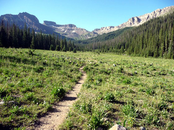
Looking south from the trailhead toward Coxcomb and Redcliff peaks
This trail wanders through wildflower-filled meadows and then climbs a gorgeous alpine basin to West Fork Pass. From the pass the trail drops into scenic Wetterhorn Basin with great views of Wetterhorn Peak (14,015-ft.).
See Trail Detail/Full Description
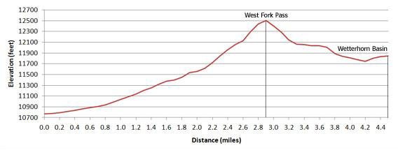
- Distance: 5.8 miles (round trip) to West Fork Pass
9.0 miles (round trip) to Wetterhorn Basin - Elevation: 10,760-ft. at Trailhead
12,517-ft. at West Fork Pass
11,850-ft. at Wetterhorn Basin - Elevation Gain: 1,757-ft. to West Fork Pass
-667-ft. to Wetterhorn Basin - Difficulty: moderate
- More Hikes in:
Ouray / Southwest Colorado
Why Hike Wetterhorn Basin
Heading south on Highway 550 near Ridgway a panorama of the alluring summits and jagged ridges of the Uncompahgre Wilderness fill the eastern skyline, enticing hikers to explore. Several trails penetrate this wilderness from the north, traveling up pretty valleys to scenic passes with dramatic mountain views.
In my opinion the Wetterhorn Basin trail is the finest hike entering the area from the north. The trail gently ascends the beautiful West Fork Cimarron River valley, wandering through scenic meadows beneath Fortress (13-241-ft.), Redcliff (13,642-ft.) and Coxcomb (13,654-ft.) peaks to the head of the valley. Here it climbs a gorgeous alpine basin to West Fork Pass (12,517-ft.).
Just beyond the pass viewpoints showcase stunning Wetterhorn Peak (14,015-ft.) and the emerald green meadows of Wetterhorn Basin. A great lunch spot on the ridge just below the pass offers panoramic views of the basin, the peaks towering above Cow Creek drainage to the southwest and the Sneffels range to the west. Alternatively, hike into the basin to the base of Wetterhorn Peak for a more intimate view.
Elevation Profile
| Buy the BookThis opinionated guide includes all the hikes in the Ouray, Telluride, Silverton and Lake City sections of the website plus info on local services and nearby attractions. |
Trail Resources
Trail Detail/Full Description / Trail Photo Gallery / Trail Map
Basecamp(s) Information:
Ouray
Region Information:
Southwest Colorado
Other Hiking Regions in:
Colorado