Minnie Gulch 
Distance: 5.1 - 6.3 miles (round trip)
San Juan National Forest, near Silverton in Southwest Colorado
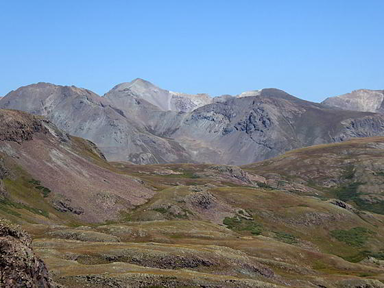
View to the north of Handies Peak
Alpine meadows, far-reaching views and solitude are the hallmarks of this scenic trail that ascends Minnie Gulch to the Continental Divide Trail (CDT) and then follows the CDT in either direction (or both) accompanied by amazing, panoramic views. The hike can easily be shorten or extended.
See Trail Detail/Full Description
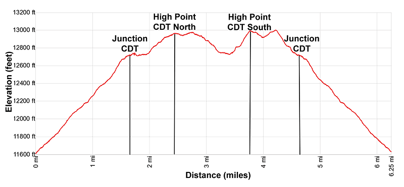
- Distance: 6.3 miles (round trip) to Minnie Gulch
- Elevation: 11,600-ft. at Trailhead
12,960-ft. at Minnie Gulch - Elevation Gain: 1,670-ft. to Minnie Gulch
- Difficulty: moderate-strenuous
- More Hikes in:
Silverton / Southwest Colorado
Why Hike Minnie Gulch
The Continental Divide (CDT) and Colorado Trails follow an undulating route along the high ridges to the east of Silverton with splendid, nonstop views of the San Juan Range. The Minnie Gulch hike samples a section of this alpine wonderland.
A 4WD with good clearance is required to reach the trailhead, located above timberline at the end of the rocky Minnie Gulch Road. From the trailhead the path climbs through alpine meadows to the head of the valley and a junction with the CDT. Here hikers have the choice of exploring the northbound or southbound section of the CDT or both.
The trail to the north ascends to an overlook above Cuba Gulch with views extending north to the summits towering above Cuba Gulch, Cottonwood Creek and the Lake Fork of the Gunnison River, including Handies, Sunshine and Redcloud Peaks. The southbound trail climbs to the ridge separating Minnie and Maggie Gulches and then descends a short distance along the ridge into Maggie Gulch. Vistas on this leg of the trail stretch south to Canby Mountain, Sheep Mountain and the high peaks of the Weminuche Wilderness.
Both trail segments features views of the summits rising around the Pole Creek Valley to the east and peaks towering above the Animas River Valley and nearby valleys to the west/southwest. The hike can be shortened by hiking only one segment of the CDT or extended by following a trail along the San Juan/Hinsdale county lines above the east side of Minnie Gulch or by continuing south along the CDT to the head of Maggie Gulch.
Keep an eye on the weather. The exposed alpine meadows are not the place to be during the thunderstorm. Before setting out be sure to check the condition of the Minnie Gulch Road at the Silverton Visitor Center.
Elevation Profile
| Buy the BookThis opinionated guide includes all the hikes in the Ouray, Telluride, Silverton and Lake City sections of the website plus info on local services and nearby attractions. |
Trail Resources
Trail Detail/Full Description / Trail Photo Gallery / Trail Map
Basecamp(s) Information:
Silverton
Region Information:
Southwest Colorado
Other Hiking Regions in:
Colorado