See Forever / Bear Creek Loop 
Distance: 5.5 - 8.4 miles (loop)
Uncompahgre National Forest, near Telluride in Southwest Colorado
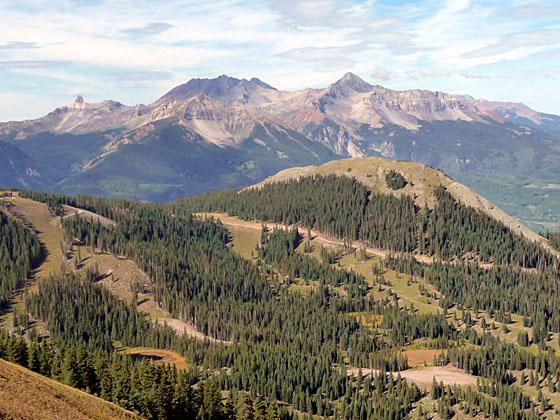
View of the Lizardhead Wilderness area to the west
This interesting loop hike features panoramic views of Telluride, Bear Creek Canyon and the distant peaks of the Lizard Head Wilderness.
See Trail Detail/Full Description
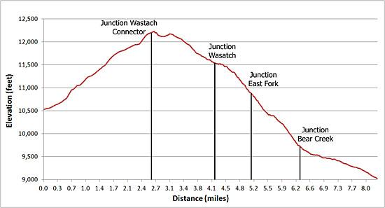
- Distance: 5.5 miles (round trip) to See Forever
1.5 miles (one way) to Wasatch Connector Trail
8.4 miles (loop) to Wasatch and Bear Creek Trails - Elevation: 10,540-ft. at Trailhead
12,100-ft. at See Forever
11,530-ft. at Wasatch Connector Trail
8,820-ft. at Wasatch and Bear Creek Trails - Elevation Gain: 1,560-ft. to See Forever
-570-ft. to Wasatch Connector Trail
-2,710-ft. to Wasatch and Bear Creek Trails - Difficulty: strenuous
- More Hikes in:
Telluride / Southwest Colorado
Why Hike See Forever / Bear Creek Loop
This interesting loop hike, starting at the St. Sophia gondola station in the Telluride Ski Area, is actually a combination of four trails, the See Forever, the Wasatch Connector, a segment of the Wasatch Trail and the Bear Creek Trail, each with its own distinct personality.
Be forewarned that the See Forever portion of the hike traverses ski slopes and follows gravel ski service roads. I am typically not a big fan of road walking or hiking in ski areas, but the panoramic views of peaks rising above the Telluride Valley and the Lizard Head Wilderness more than compensate for the less than desirable trail conditions for the first 2.75 miles of the hike.
Just 0.4 miles down the Wasatch Connector trail you leave the ski area behind and head for the beautiful upper basin of the Bear Creek drainage and dramatic Bear Creek Canyon. This portion of the trail enjoys wonderful views of the Wasatch basin, the incredible peaks defining the north wall of the Telluride Valley and the sculpted cliffs of the Bear Creek canyon.
Note that the 8.4-mile loop is best done in a counter-clockwise direction and involves sections of steep switchbacks gaining 1,540-ft. and dropping 3,280-ft. (Reverse the gains and losses if you hike in a clockwise direction.)
Elevation Profile
| Buy the BookThis opinionated guide includes all the hikes in the Ouray, Telluride, Silverton and Lake City sections of the website plus info on local services and nearby attractions. |
Trail Resources
Trail Detail/Full Description / Trail Photo Gallery / Trail Map
Basecamp(s) Information:
Telluride
Region Information:
Southwest Colorado
Other Hiking Regions in:
Colorado