Lost Lake 
Distance: 7.4 - 10.5 miles
Absaroka Beartooth Wilderness, Custer National Forest, near Red Lodge in Beartooth Mountains
Lost Lake
A pleasant hike up the Lake Fork of Rock Creek visits Broadwater and Lost Lakes. Along the way enjoy fine views of Rock Creek and the rugged cliffs of the Silver Run and Hellroaring Plateaus along with occasional views of the summits rising above the head of the valley.
- Distance: 7.4 - 10.5 miles (RT)
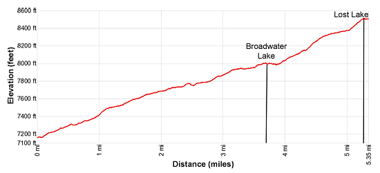
- Elevation: 7,165-ft. at Trailhead
Maximum elevation - 8,515-ft. - Elevation Gain: 1,350-ft.
- Difficulty: moderate
- Basecamp: Red Lodge
- Region: Beartooth Mountains
Trail Description - Lost Lake
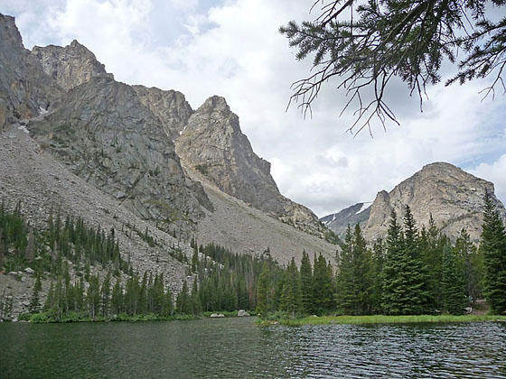
The Lake Fork of Rock Creek flows down a pretty glacial valley sandwiched between the 10,000-ft. high cliffs of the Silver Run and Hellroaring Plateaus. From the trailhead at the end of the Lake Fork Road (see driving directions below), the trail curves to the left (south) and crosses a bridge to the south side of the Lake Fork of Rock Creek. Here the path turns right (west) and ascends on easy to moderately-easy grades through forest near the creek. Openings offer nice views of the creek and the rugged slopes rising above the trail.
At 1.2 miles the trail travels through a few meadows with fine views of the creek and the sheer cliffs of the Silver Run Plateau. Thunder Mountain (11,446-ft.) and Whitetail Peak (12,548-ft.) rise above the trees at the head of the valley. An area of downed trees at 2.4 miles provides more great views of the craggy walls towering above the valley floor.
At 2.75 miles the trail travels starts traveling beside the creek. Soon views open to a waterfall tumbling down the rugged slopes above the trail.
At 3.6 miles a short spur trail branches right to beautiful Broadwater Lake, really a broad channel along the creek. Take a short detour on the spur trail which quickly reaches the meadows at the east end of the lake. Here views stretch west to Peak 10,913-ft. and Thunder Mountain guarding the entrance to the short side canyon harboring Black Canyon Lake. Broadwater Lake is a good turn around point for parties looking for a shorter day (7.4 miles round trip hike).
Return to the main trail to continue to Lost Lake. The path now travels through scattered trees to the south of the pretty Broadwater Lake. Along the way enjoy more nice views of the channel and the peaks rising above the head of the valley.
Beyond Broadwater the grade steepens a bit and crosses an avalanche chute at 4.0 miles. Soon the forest thickens, restricting the views.
At 5.0 miles reach the junction with the trail to Lost Lake, branching left (south). Turn left and follow the spur trail as it ascends on moderate grades to Lost Lake at 5.25 miles. The rugged slopes of Peak 10,913-ft. dominate the views across the lake to the south. Peak 10,583-ft. and Thunder Mountain rise to the west.
Use/social trails leads to various viewpoints and campsites along the north side of the lake. The lake is a nice spot to relax and take in the views. Fishermen might want to try their luck catching some of the lake’s Graylings and cutthroat trout. When your done enjoy the lake retrace your steps to the trailhead.
It is possible to continue beyond Lost Lake to Keyser Brown Lake at 7.0 miles (14-miles round-trip). Keyser Brown features terrific views of Sky Pilot Mountain towering above the head of the Lake Fork valley. Thunder Mountain looms above the lake to the south while Mount Lockhart (11,647-ft.) and Whitetail Peak (12,548-ft.) fill the skyline to the west.
Due to the length of the hike, Keyser Brown is best done on an overnight backpack. The heavily-used campsites around the lake attest to the lake’s popularity so don’t expect solitude. A good stock of brook and cutthroat trout will tempt fishermen to visit the lake.
Elevation Profile
Driving Directions
From Red Lodge, MT: Drive southwest on US 212 W (the Beartooth Highway) for 10.6 miles and turn right on the Lake Fork Road. Travel along Lake Fork Road to 1.8 miles to the parking area at the end of the road. The trail leaves from the southwest end of the parking lot.
Trail Resources
- Trail Photo Gallery
- Trail Maps
- Basecamp(s) Information: Red Lodge
- Region Information: Beartooth Mountains
- Other Hiking Regions in: Montana