Details: Dawson Pitamakan Loop 
Distance: 15.2 - 17.4 miles (round trip)
Glacier National Park, near Two Medicine in Glacier Natl Park, MT
Hike Facts
- Distance: 15.2 - 17.4 miles (round trip)
- Elevation: 5,170-ft. - 8,138-ft.
- Elevation Gain: 2,430-ft. - 2,968-ft.
- Difficulty: strenuous
- Trail Highlights: See Trail Intro
- Basecamp(s): Two Medicine / St Mary
- Region: Glacier Natl Park, MT
This long, strenuous hike, best done as a backpack, travels through some of the best scenery in the southern half of Glacier National Park.
To Dawson Pass
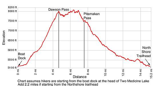
Distance from Trailhead: 6.5 miles (one way)
Ending/Highest Elevation: 7,600-ft.
Elevation Gain: 2,430-ft.
Before starting your hike check current trail conditions at the Two Medicine Ranger Station. Trails in the area are occasionally closed due to bear activity. Snow can linger on the high passes well into the summer.
Dawson Pass Trail Junction via the North Shore trail
The trail to Dawson Pass starts at the North Shore trailhead, located at the north end of the Two Medicine campground (see driving directions below). From the North Shore trailhead at the outlet of Pray Lake head west, crossing the bridge over the outlet stream. At 0.1 miles reach the junction with the Pitamakan Pass trail branching to the right. Bear left on the North Shore trail toward Twin Falls and Dawson Pass.
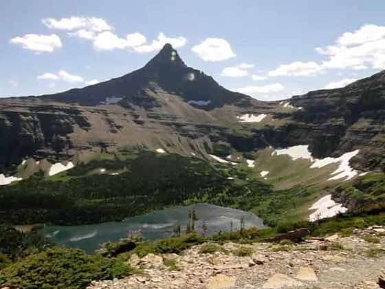
Follow the trail as it traverses the north side of Pray Lake, passing through some trees and then open meadows with nice views of Appistokie Peak (8,164-ft.) rising to the south. Reach the northeast end of Two Medicine Lake after walking a little over 0.25 miles.
The trail now travels on easy grades along the north shore of Two Medicine Lake beneath massive Rising Wolf Mountain (9,513-ft.), passing through stands of conifers and meadows. The meadows, created by avalanches plowing down the slopes of Rising Wolf, feature wonderful views of the peaks to the south/southwest including Mt. Ellensworth (8,591-ft.), Never Laughs Mountain (7,641-ft.), Grizzley Mountain (9,067-ft.), Painted Tepee Peak (7,650-ft.) and Sinopah Mountain (8,271-ft.), which towers above the head of the lake.
At 0.8 miles views open to a beautiful waterfall tumbling down Rising Wolf’s craggy slopes and lush meadows. The mountain’s open slopes and avalanches chutes are favorite habitats for bears foraging for food. Keep an eye out for bears on the upper slopes and be sure to make noise so you do not surprise one of these majestic creatures foraging in the high brush near the trail.
Climb a short, moderately steep slope up a mound at the end of an avalanche chute at 2.0 miles, gaining 100-ft. in 0.2 miles. At the top of the slope rock hop across the stream cascading down the chute and then follow the trail as it drops down the other side of the mound.
Reach the northwest end (head) of the lake at 2.5 miles. Soon the trail enters the trees and begins a moderate climb to a junction at 3.1 miles. Turn right (northwest) on the trail to No Name Lake and Dawson Pass. The trail to the left (southwest) leads to Twin Lakes/Upper Two Medicine Lake and the boat dock at the west end of the lake (via a spur trail).
[Skip the next section and continue reading “To Dawson Pass”]
Dawson Pass Trail Junction from the boat dock at the foot (east end) of Two Medicine Lake
Hikers can ride the tour boat on Two Medicine Lake (5,164-ft.) to shorten the distance to Dawson Pass by 2.2 miles (one-way) or 4.4 miles (round-trip). The boat travels to the head (west end) of the lake where trails connect to a variety of destinations, including Dawson Pass.
The cruise across the lake is accompanied by a commentary on the Blackfoot Indian folklore related to the Two Medicine Valley and offers stunning views of Painted Teepee Peak (7,650-ft.), Sinopah Mountain (8,271-ft.), Lone Walker Mountain (8,502-ft.), Finsch Peak (9,225-ft.) and Rising Wolf Mountain (9,513-ft.). Consult the Glacier Park Boat Company (http://www.glacierparkboats.com/) website for schedules and tour costs.
From the boat dock at the head of the lake a trail heads west on easy grades, crossing boardwalks as it passes through a marshy area. In a short distance arrive at the junction with the South Shore trail, branching off to the left. Continue straight ahead. Soon the trail enters the woods.
Cross a bridge over Two Medicine Creek at 0.6 miles and reach a second trail junction at 0.75 miles. To the left is the trail to Twin Falls (0.3 miles) and Upper Two Medicine Lake (1.5 miles). Turn right (northeast), following the Dawson Pass Cutoff trail through trees and small meadows toward the Dawson Pass Trail. Rising Wolf Mountain looms above the valley to the north while the distinctive spire of Pumpelly Pillar (7,625-ft.), an impressive knife-shaped wall of rock, rises above the trees to the west.
Turn left upon reaching the junction with the Dawson Pass trail at 0.9 miles. The trail to the right is the North Shore trail that leads to the North Shore trailhead trailhead in the Two Medicince Campground at the east end of the lake.
To Dawson Pass
In the next two sections the trail mileage is listed as A/B where A reflects the distance from the boat dock and B is the distance from the North Shore trailhead.
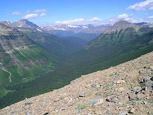
Follow the Dawson Pass trail as it ascends the Bighorn Basin on moderately steep grades, traveling through pretty meadows and stands of subalpine firs. The meadows afford wonderful views of Mt. Rockwell (9,272-ft.) and Long Walker Mountain rising above the upper Two Medicine Valley along with every improving views of the Pumpelly Pillar.
At 1.6/3.8 miles jump over a small creek cascading down an avalanche chute. Openings in the trees offer your first views of the ridge running between Rising Wolf Mountain and Flinsch Peak on the north side of the basin.
At 1.8/4.0 miles the grade abates. Over the next 0.4 miles the trail travels on easy grades, crossing three small creeks. Through the trees catch glimpses of Pumpelly Pillar’s craggy western ridge.
Arrive at the junction with the spur trail to No Name Lake (5,925-ft.), branching to the left (south), at 2.4/4.6 miles. The rugged cliffs of Pumpelly Pillar form the backdrop for this small, scenic lake, situated 0.2 miles below the trail. Three campsites are dispersed among the trees to the west of the lake. (See the Backcountry Camping page for information about reserving campsites at Glacier National Park - http://www.nps.gov/glac/planyourvisit/backcountry.htm.)
Turn right at the junction and follow the Dawson Pass trail as it climbs steeply up the southern flanks of Flinsch Peak toward the pass, gaining almost 1,600-ft in a little under 2 miles. Initial the ascent is through trees which soon give way to meadows that afford fine views of Rising Wolf Mountain, Mt. Helen (8,538-ft.), Pumpelly Pillar, No Name Lake and, in the distance, Two Medicine Lake.
At 3.8/6.0 miles views open to Dawson Pass (7,602-ft.), the saddle on the ridge running between Flinsch Peak to the north and Mt. Helen to the south. Keep an eye out for bighorn sheep and mountain goats grazing on the nearby slopes as you continue to the pass.
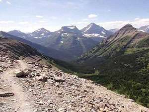
Reach Dawson Pass (7,600-ft.), located on the continental divide, at 4.3/6.5 miles. Here a stunning panorama of peaks in the Lewis Range spring into view. Mt. Pinchot (9,210-ft.), Mt. Stimson (10,142-ft.), Mt. Thompson (8,527-ft.), Blackfoot Mountain (9,574-ft.) and Mt. Logan (9,239-ft.) grace the skyline to the northwest. Across the valley to the west Mt. Phillips (9,494-ft.) and the remains of the Lupfer Glacier dominate the scene. Almost 3,000-ft. beneath the imposing peak Nyack Creek meanders through the beautiful Nyack valley. The towering peaks to the southwest include Caper Peak (8,310-ft.), Battlement Mt. (8,830-ft.) and the distinctive summit of Mount St. Nicholas (9,376-ft.). The stark profiles of Flinsch Peak and Mt. Morgan frame the view to the north of the pass while Mt. Helen, rises to the south.
The pass, named after Thomas Dawson a Blackfoot descendent who was a guide in Glacier National Park, is notorious for its ferocious winds. Be sure to carry warm clothing and use caution when exploring near the sheer drop-offs around the pass. The exposed pass is not the place to be during a storm. Retreat to lower elevations if you see bad weather approaching.
To Pitamakan Pass and Completing the Loop
Distance from Trailhead: 17.4 miles (loop)
Ending/Highest Elevation: 8,138-ft.
Elevation Gain: 2,968-ft.
From Dawson Pass, the trail turns north toward Flinsch Peak, climbing the slopes along the east side of divide and then crosses to the west of the divide at 4.8/7.0 miles. Along the way enjoy great views of Bighorn Basin.
On the west side of the divide the narrow trail continues north, clinging to the steep scree covered slopes along the western flanks of Flinsch Peak. Progress will be slow along this section of the trail as you will stop often to take in the spectacular scenery. Reach the saddle between Flinsch and Mt. Morgan at 5.9/8.1 miles. The saddle enjoys fine views of Old Man Lake and the peaks rimming the Dry Fork Valley.
From the saddle the narrow trail travels along the western slopes of Mt. Morgan, crossing a ridge at 6.6/8.8 miles. A rock ledge, the Pitamakan Overlook, protrudes from the far side of the ridge. This incredible overlook offers fabulous views west to Mt. Stimson and the sea of peaks towering above the Nyack / Coal Creek valley. To the south, Mt Phillips and Mt. Flinsch dominate the skyline while to the north McClintock Peak and Tinkham Mountain frame a sea of peaks along the Lewis Range.
Beyond the overlook the trail traverses beneath the western slopes of Mt. Morgan for 0.5 miles and then crosses a ridge to the eastern side, leaving the Continental Divide. Wonderful views of the jagged peaks lining the Cut Back Valley open to the north and east. Below are the shimmering waters of Pitamakan Lake and the Lake of the Seven Winds.
Follow the trail as it descends southeast to Pitamakan Pass (7,575-ft.), the saddle on the narrow ridge separating the Cut Bank and Dry Fork drainages, 3.25 miles from Dawson Pass (7.6 miles from the boat dock/9.8 from the North Shore trailhead). Below the pass to the south is Old Man Lake (6,646-ft.).
From the saddle the trail drops down steep, rocky switchbacks to the junction with the spur trail to Old Man Lake at 9/11.2 miles. Flinsch Peak and Mt. Morgan beautifully frame this photogenic tarn, located 0.3 miles down the spur trail. Four campsites are dispersed among the old growth whitebark pines at the foot of the lake.
The trail now heads east, descending the pleasant Dry Fork Valley, passing through pretty meadows and stands of fir and lodgepole pines with occasionally stream crossings. Rising Wolf Mountain towers above the south side of the valley. Open areas offer nice views of the peaks rising above the head of the valley.
Reach the junction with the trail back to Two Medicine Lake at 12.7/14.9 miles. The junction is right after you cross a creek cascading down the valley’s northern slope. Turn right toward Two Medicine Lake. The trail branching to the left continues down the Dry Fork Valley to the National Park entrance station at the Two Medicine Road.
Follow the trail as it heads southeast, traveling around the eastern end of Rising Wolf Mountain. At 13.5/15.7 miles the trail ascends and crosses a low ridge before continuing its descending traverse back to the trailhead. Total distance for the hike from the boat dock is 15.2 miles or 17.4 miles via the North Shore trail.
Elevation Profile
Driving Directions
From Two Medicine: From US Highway 2 in Two Medicine, turn north on Montana-49 N. Drive 4.1 miles on 49-N and turn left on Two Medicine Road. Travel along Two Medicine Road to 7.2 miles. Turn right (north) on the road to the Two Medicine Campground. Follow the main campground road to its end and the Two Medicine North Shore trailhead at the foot of Pray Lake, located to the northeast of Two Medicine Lake.
From St. Mary: Head south on Rt. 89 for 18.9 miles and turn right onto MT 49 S. Follow the narrow, twisty road for 7.5 miles and then turn right onto Two Medicine Road. Travel along Two Medicine Road to 7.2 miles. Turn right (north) on the road to the Two Medicine Campground. Follow the main campground road to its end and the Two Medicine North Shore trailhead at the foot of Pray Lake, located to the northeast of Two Medicine Lake.
Via Boat: The Glacier Park Boat Company (http://www.glacierparkboats.com/) runs boat tours on Two Medicine Lake. The boats travel to the head of the lake where trails connect to a variety of destinations, including the trail to Dawson Pass. Hikers can ride the boats either one way to round trip to shorten the hiking distance to the pass.
The dock is located near the foot of Two Medicine Lake. To reach the boat dock from US Highway 2 in Two Medicine, turn north on Montana-49 N. Drive 4.1 miles on 49-N and turn left on Two Medicine Road. Travel along Two Medicine Road for 7.3 miles to the parking area at the end of the road. The boat dock and kiosk for purchasing tickets is at the southwest end of the parking area. During the height of the summer it is advisable to get reservations a day ahead of time. See the Glacier Park Boat Company website for departure schedules, costs and contact information.
Trail Resources
Trail Intro / Trail Photo Gallery / Trail Map
Basecamp(s) Information:
Two Medicine / St Mary
Region Information:
Glacier Natl Park, MT
Other Hiking Regions in:
Montana