Scenic Point 
Distance: 6.2 - 7.7 miles
Glacier National Park, near Two Medicine in Glacier Natl Park, MT
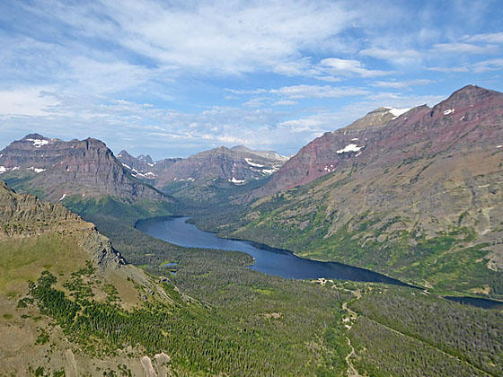
Peaks towering above Two Medicine Lake
Panoramic, bird’s-eye-views of the high peaks rimming the Two Medicine Valley and beyond is the reward for hikers making the sustained, moderately-steep climb to a ridge high above the southeast end of Two Medicine Lake.
- Distance: 6.2 - 7.7 miles (RT)
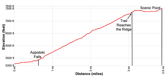
- Elevation: 5,268-ft. at Trailhead
Maximum elevation - 7,522-ft. - Elevation Gain: 2,254-ft.
- Difficulty: moderate-strenuous
- Basecamp: Two Medicine
- Region: Glacier Natl Park, MT
Trail Description - Scenic Point
The Mt Henry Trail to Scenic Point starts off a spur road, about a half miles west of Two Medicine Lake (see driving directions below). The trail initially travels through forest, heading east and then curves around to the south. Upon reach the Appistoki Creek the trail turns northeast. At 0.6 miles pass the junction with the short spur trail to Appistoki Falls. A 150-ft detour leads to the falls along its namesake creek.
Beyond the falls the trail starts climbing switchbacks on moderate-steep grades up the east side of the Appistoki Valley. Soon the trees thin and views open to the Appistoki Peak (8,164-ft.) towering above the west side of the valley. Rising Wolf Mountain (9,513-ft.) fills the skyline to the northwest.
After a mile the trail leaves the last of the trees behind as it climbs through talus and meadows, passing a few dead whitebark pine trees. The gnarled trees, killed by a fungal infection long ago, are now bleached white and are quite photogenic.
As the trail ascends view open to Mount Henry (8,847-ft.), towering above the head of the valley to the south. At 1.6 miles the trail turns left (north/northeast) at the end of a long switchback. Soon the grade steepens as the path ascends steep switchbacks up a cliff band. To the northwest views extend to Dawson Pass and beyond.
At 2.0 miles the trail goes through an interesting cluster of whitebark pines sculpted by the elements into weird and wonderful shapes. A quarter mile past the trees the grade reverts back to a steady, moderately-steep climb up switchbacks. To the west are terrific views of Sinopah Mountain (8,271-ft.) and Rising Wolf Mountain towering above Two Medicine Lake. Mount Rockwell (9,272-ft.), Long Walker Mountain (8,502-ft.) and Mount Helen (8,538-ft.) rise above the head of the Upper Two Medicine Valley.
Reach the top of the switchbacks at 2.6 miles. Here the trail turns southeast and climbs to a saddle on the ridge at 3.1 miles. The ridgetop enjoys great views of the Appistoki Valley and the Two Medicine area. This, based on the mileage on the park service sign at the beginning of the trail, is Scenic Point.
If time and energy allows, it is worth continuing along the trail for 0.8 miles to Scenic Point as show on the Dancing Lake Mountain USGS topographic Map. If you look northeast along the ridge you will see a ledge protruding from the ridgetop. This is Scenic Point per the USGS map.
From the saddle the trail briefly travels along the west side of the ridge. Footing is difficult if snow is present. People with a fear of height will also be uncomfortable with the sheer drop-offs. Use judgement and turn around if the trail is unsafe or makes you uncomfortable.
At 3.3 miles the trail crosses to the east side of the ridge. Here views stretch east toward the Blackfeet Reservation. The trail now ascends on easy grades to an unmarked junction at 3.85 miles. Turn left at the junction and climbs steeply to the ledge atop the ridge (7,522-ft.) at 3.9 miles. This is Scenic Point. To the east below the ledge are fine views of Lower Two Medicine Lake. Spot Mountain (7,831-ft.) rises above the foot of the Dry Fork Valley to the north. The high peaks rimming the Two Medicine Valley fill the skyline to the west.
The Mt Henry Trail continues beyond the unmarked turnoff, descending southeast to East Glacier in 6.3 miles. Most parties turn around at this point and retrace their steps to the trailhead for a 7.7 mile round-trip hike.
Elevation Profile
Driving Directions
From East Glacier, MT: From the intersection of US Highway 2 and MT-49 North in East Glacier, drive north on MT-49 for 4.1 miles and the turn left onto Two Medicine Road. Follow Two Medicine Road for 6.9 miles. On the left (southeast) side of the road is a spur road signed for Scenic Point. Turn left here and park in the obvious parking lot along the right (west) side of the road. The signed trailhead for the Mt Henry Trail to Scenic Point is on the left (east) side of the road.
Trail Resources
- Trail Photo Gallery
- Trail Maps
- Basecamp(s) Information: Two Medicine
- Region Information: Glacier Natl Park, MT
- Other Hiking Regions in: Montana