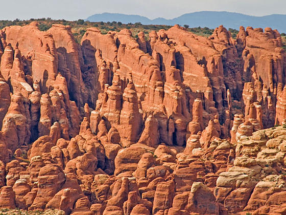
View of the Fiery Furnace from the overlook
The Fiery Furnace hike travels through a fascinating labyrinth of fins, narrow canyons and weird rock formations. Agility and proper footwear are required to complete the demanding route only accessible on a Ranger-led hike or with a day-use permit.
- Distance: 2.3 miles (Loop)
- Elevation: 4,730-ft. at Trailhead
Maximum elevation - 4,980-ft. - Elevation Gain: 250-ft.
- Difficulty: moderate-strenuous
- Basecamp: Arches / Moab
- Region: Southeast Utah
Trail Description - Fiery Furnace
The Fiery Furnace hike follows a circuitous route through an entertaining sandstone maze, traveling beneath towering walls, squeezing through tight cracks, wandering along narrow corridors and scrambling over slickrock formations. Along the way the route visits Skull Arch, a double arch rising above Raven Canyon, Surprise Arch, Crawl-through-Arch and Flatiron Arch along with Walk-through-Bridge.
Providing hiking directions for this fascinating area, named from the sandstone’s red and orange glow when lit by the setting sun, is next to impossible. For most hikers the 2 1/2 hour Ranger-led hike through the area is the best option. Tickets for these hikes, offered twice a day from March to October, are in high demand and reservations are required through Recreation.gov.
Please be aware that this is a physically demanding hike that crosses narrow ledges above drop offs, traverses broken and irregular sandstone and requires some scrambling over obstacles. In spots you must squeeze between narrow cracks, jump across gaps and pull yourself up and through openings. Hiking shoes or boots with gripping soles are required. Each person must carry water (one quart or more) in a backpack permitting your hand to be free for navigating the terrain.
Despite its name the hike through Fiery Furnace is shady and can be quite cool. Bring a jacket during the shoulder season.
As an alternative to the ranger-led hike, day-use permits are available for experienced hikers well versed in route finding. This is a place where it is easy to get turned around and lost. Do not under estimate the difficulty in navigating through this maze. Your GPS will be inoperable due to the topography of the area. My advice is to take a ranger-led tour first before making a decision to visit this amazing area on your own.
Driving Directions
From Moab: Drive northwest on US 191-N for 4.6 miles and turn right onto the Arches National Park Entrance Road. Travel along the road for 0.6 miles to the park entrance station where you pay park fees and obtain park brochures. (First time visitors should stop at the Visitor Center, located on the right 0.2 miles up the road from the Entrance Station to view the exhibits and obtain information about current park conditions.)
Beyond the entrance station drive 14.0 miles and turn left into the Fiery Furnace area. Along the way pass turnoffs for the Windows Area at 9.3 miles and Delicate Arch at 11.5 miles. The trailhead is located at the northeast end of the parking area. A trail on the south side of the parking area leads to a scenic overlook.
Trail Resources
- Trail Photo Gallery
- Trail Maps
- Basecamp(s) Information: Arches / Moab
- Region Information: Southeast Utah
- Other Hiking Regions in: Utah