Lower Fish Creek Canyon 
Distance: 3.6 - 8.0 miles (round trip)
BLM, Monticello, Utah office, near Bluff in Southeast Utah
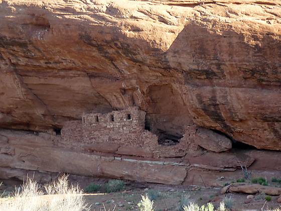
Looking across the canyon at ruins tycked in an alcove beneath a large overhang
A moderately-easy hike up a pleasant, shallow canyon with Ancestral Puebloan ruins and a few rock art sites.
See Trail Detail/Full Description
- Distance: 3.6 miles (round trip) to Best Ruins
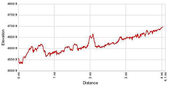
8.0 miles (round trip) to View of Tower Ruin - Elevation: 4,550-ft. at Trailhead
4,610-ft. at Best Ruins
4,700-ft. at View of Tower Ruin - Elevation Gain: 60-ft. to Best Ruins
210-ft. to View of Tower Ruin - Difficulty: easy-moderate
- More Hikes in:
Bluff / Bears Ears NM / Southeast Utah
Why Hike Lower Fish Creek Canyon
This pleasant off-the-beaten-path trail in lower Fish Creek Canyon offers a degree of solitude not found on other trails in the area. Starting near the confluence of Fish Creek and Comb Wash, the trail heads west/northwest up the shallow canyon along scrub covered benches.
After walking 1.3 miles observant hikers will spot the first ruin across the canyon. Over the next 2.7 miles there are 6 more ruins, two of which contain multiple structures and rock art. The other ruins are granaries and/or small ruins tuck into the cliff side. The last is a ruin atop the south rim that was possibly a lookout tower.
This description covers the first four miles of the canyon. Beyond that point the trail continues up canyon to the confluence of McCloyd and Owl Canyons, offering a variety of options for point-to-point backpacks.
Much of the trail is exposed and can get hot in the full sun. Be sure to carry plenty of water.
Elevation Profile
Trail Resources
Trail Detail/Full Description / Trail Photo Gallery / Trail Map
Basecamp(s) Information:
Bluff / Bears Ears NM
Region Information:
Southeast Utah
Other Hiking Regions in:
Utah