Peekaboo Trail 
Distance: 8.0 - 10.4 miles
Needles District, Canyonlands National Park, near Canyonlands in Southeast Utah
Massive ridge rising to the south
The terrific hike features non-stop views of the ever changing panorama of weird and wonderful sandstone formations, canyons, buttes and mesas stretching north to the La Sal Mountains. The last segment features an extended high elevation walk along slickrock bench and over ridges.
- Distance: 8.0 - 10.4 miles (RT)
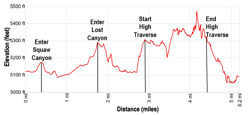
- Elevation: 5,122-ft. at Trailhead
Maximum elevation - 5,475-ft. - Elevation Gain: 353-ft.
- Difficulty: strenuous
- Basecamp: Canyonlands / Monticello
- Region: Southeast Utah
Trail Description - Peekaboo Trail
The Peekaboo Trail starts by crossing Squaw and Lost Canyons. The final segment of the trail features nonstop views during an exhilarating high traverse through an expansive slickrock wonderland, bench walking along canyon rims and climbing ramps and ledges over ridges as it navigates a circuitous route between Lost Canyon and Salt Creek Canyon.
Hikers should be comfortable following a cairned route and hiking friction pitches. There is some minor exposure near the end of the hike. There are a lot of ups and downs along the trail, making the total elevation gain and lost over 1,000-ft.
The Peekaboo Trail starts at the Squaw Flat trailhead, located along the south side of the Squaw Flat Campground Loop “A” Road. (See driving directions below.) From the trailhead, walk south for 200-ft. to a trail junction. To the left is the trail to Squaw Canyon, Lost Canyon and Peekaboo. To the right is the path to Big Spring Canyon. Turn left toward Peekaboo and follow the trail as it crosses flat, scrub covered desert terrain to a low sandstone ridge at 0.2 miles.
Rock cairns mark the trail climbing to the top of the ridge and then descending into Squaw Canyon. At the top of the ridge enjoy nice views of the slickrock formations rising above the campground to the north/northwest and the La Sal Mountains to the northeast.
The path now head southeast up the west side of Squaw Canyon, traveling through scrub covered flats scattered with junipers. At 1.1 miles the path crosses the Squaw Canyon wash and reaches a junction where the Squaw Canyon trail branches right. We take the left fork toward Lost Canyon and Peekaboo.
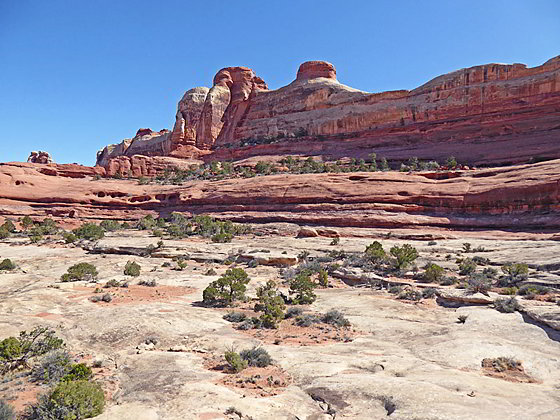
Past the junction the trail ascends on gentle grades across scrub-covered flats before arriving at a second sandstone ridge at 1.6 miles. Rock cairns mark the short, steep climb to the ridge crest where views open in all directions to a world of colorful sandstone formations. In the distance to the north views extend to Junction Butte and Grand View Point in the Island in the Sky District of Canyonlands.
The cairned trail now curves to the left (east/southeast) as it descends the ridge’s slickrock slopes to the floor of a tributary of Lost Canyon. A metal ladder aids a portion of the descent. Carefully follow the rock cairns along this section of the trail. When following cairns it is always best to look ahead and find the next cairn before proceeding.
In the tributary canyon the trail travels along the wash for a short distance and then proceeds over scrub covered benches to the junction with the Lost Canyon Trail at 2.5 miles. Here the Lost Canyon trail turns right. We bear left (southeast) toward Peekaboo. The trail crosses the Lost Canyon wash and soon passes the Lost Canyon Campsite #1. A short distance beyond the path starts a steep ascent up rugged slopes. In places you may need to use your hands.
The path leads to the base of a slickrock pour-off at 2.75 miles. The trail now ascends steeply up the pour-off, scrambling up ledges and friction pitches. Near the top of the pour-off rock cairns mark a turn to the left where the trail climbs to the top of a ridge at 2.8 miles.
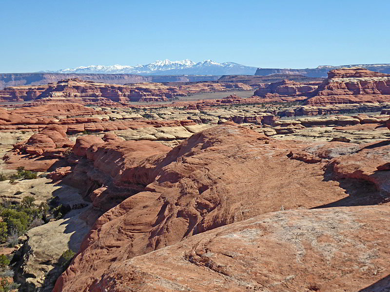
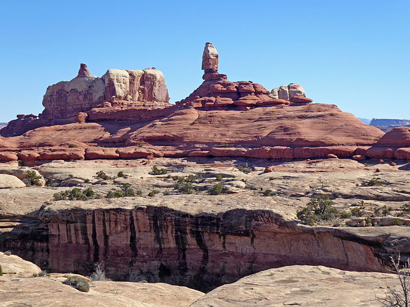
Here we enjoy terrific views of the massive ridge, topped by fins, spires and knobs, rising to the south. The ridge towers above an expanse of slickrock benches rimming several north trending side canyons. To the north the La Sal Mountains and the Island in the Sky mesa form the backdrop for a sea of multihued sandstone formations in the Needles and beyond.
This is the start of an amazing 1.6 mile segment of the hike through a slickrock wonderland that travels along canyon rims and over ridges as it navigates a circuitous route between Lost Canyon and Salt Creek Canyon. The massive ridge to the south will be your constant companion along the high traverse linking the two canyons.
The trail, marked by rock cairns, utilizes a series of benches, drainages, ledges and ramps as it curves around amphitheaters at the heads of the side canyons and crosses low ridges separating the canyons. Photogenic hoodoos, knobs and fins adorn the ridge to the south.
From the ridge crest at 2.8 miles the path descends to a broad bench that curves around two tributary of Lost Canyon. The trail then climbs steeply up a series of ledges and slick rock ramps to a saddle on the ridge between Lost Canyon and Big Spring Canyon at 3.6 miles. To the north are distant views of the La Sal Mountains.
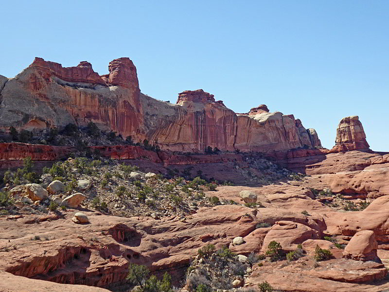
The trail soon drops off the saddle and then traverses along a high bench. The sheer walls of the ridge to the south, streaked with desert varnish, soar overhead. Along the way the trail passes above the head of two shallow tributaries of Salt Creek Canyon.
At 4.0 miles the trail uses a window in a ridge to transit between two side canyons. The window is a good turnaround point for hikers seeking a slightly shorter day.
Beyond the window the path descends to a slanted bench that curves around the amphitheater at the head of another tributary of Salt Creek Canyon. The friction pitch hike along the slanted bench has some exposure. Turn around if you are uncomfortable hiking on the slanted bench and retrace your steps to the trailhead knowing that you have experienced the best part of the high elevation traverse.
The bench soon flattens and the hiking becomes easier as the trail ascends gentle to and passes through an opening in a ridge between a tributary and the main channel of Salt Creek Canyon. On the east side of the ridge the path soon climbs atop the ridge and then descends along the ridge crest accompanied by great views of formations rising above Salt Creek Canyon and the tributary canyons to the west.
At 4.4 miles reach the end of the ridge crest. Here the path descends a slickrock chute and curves to the south and then east/northeast as it descends steeply down sickrock ramps, ledges and benches to a ladder at 4.7 miles. The 20-ft. ladder, wedged into a tight crack, drops down to some slickrock steps. The footing on the steps is not great.
Hikers with large packs will find it difficult, if not impossible, to turn around at the base of the ladder and descend the steps. Backpackers are advised to carry a rope and lower their packs down the crack.
Beyond the ladder the trail descends to a vegetated bench along the base of the cliffs rimming the west side of Salt Creek Canyon. Here the trail heads southwest. At 4.9 miles the path curves to the left (southeast) traveling along the base of a ridge extending into the canyon. Here views open to the canyon floor where you will see remnants of an old road and the creek, which may contain water depending on the time of year and recent rainfall. Soon you will see the Peekaboo Backcountry Campsite where there is a picnic table and some old cottonwood trees.
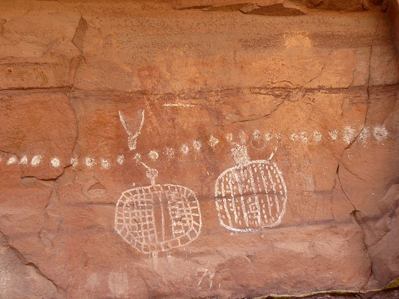
At 5.2 miles the path reaches Peekaboo Arch (aka Trail Arch). Hikers can easily walk through the arch to the other side of the ridge. Before walking though arch be sure to view the pictographs to the right of the opening. Here you will find 2 distinct figures whose bodies are large shields. The shields are set beneath a long row of white dots. This pictograph is painted over a much older Barrier Canyon style pictograph with very faint red figures. A park service information panel at the site will help you to visualize the older figures. Take some time to look around both sides of the opening for some hand prints.
Find a shady spot around the arch to enjoy lunch and then retrace your steps to the trailhead for a 10.4 mile (round-trip) hike.
This hike is best done in the spring and fall when temperatures are cooler. The trail is not recommended in the summer when temperatures can soar over 100-degrees. The hike requires a lot of ascents and descents, making it a strenuous outing, especially on a warm day in the bright sun. Most of the hike is exposed to the sun. Take plenty of water and snacks. Don’t depend on finding any walker along the way.
Elevation Profile
Driving Directions
From Moab, UT: Drive south on U.S. Highway 191 for roughly 40 miles to Utah Highway 211 (signed for Canyonlands National Park, Needles District) and turn right (west). Follow Utah Highway 211 west for 37.2 miles and turn left (west), on the road signed for the Squaw Flat Campground. The turn is located 2.8 miles beyond the Visitor Center. At the first intersection (0.3 miles) continue straight ahead on the Campground Loop A Road for 0.9 miles. (Do not turn right onto the Campground Loop B Road.) The parking area for the Squaw Flat Trailhead is located on the left (south) side of the road.
From Monticello, UT: Drive north on U.S. Highway 191 for roughly 14.3 miles to Utah Highway 211 (signed for Canyonlands National Park, Needles District) and turn left (west). Follow Utah Highway 211 west for 37.2 miles and turn left (west), on the road signed for the Squaw Flat Campground. The turn is located 2.8 miles beyond the Visitor Center. At the first intersection (0.3 miles) continue straight ahead on the Campground Loop A Road for 0.9 miles. (Do not turn right onto the Campground Loop B Road.) The parking area for the Squaw Flat Trailhead is located on the left (south) side of the road.
From Blanding, UT: Drive north on U.S. Highway 191 for roughly 34.8 miles to Utah Highway 211 (signed for Canyonlands National Park, Needles District) and turn left (west). Follow Utah Highway 211 west for 37.2 miles and turn left (west), on the road signed for the Squaw Flat Campground. The turn is located 2.8 miles beyond the Visitor Center. At the first intersection (0.3 miles) continue straight ahead on the Campground Loop A Road for 0.9 miles. (Do not turn right onto the Campground Loop B Road.) The parking area for the Squaw Flat Trailhead is located on the left (south) side of the road.
Trail Resources
- Trail Photo Gallery
- Trail Maps
- Basecamp(s) Information: Canyonlands / Monticello
- Region Information: Southeast Utah
- Other Hiking Regions in: Utah