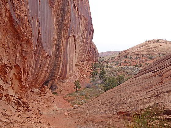
Moki Mesa from the pass
Looking for a short hike that is long on solitude and features scenic cliffs, rock art and views of the Colorado River? Then hike to Moki Mesa, situated atop a bench between the Colorado River and Poison Spider Mesa.
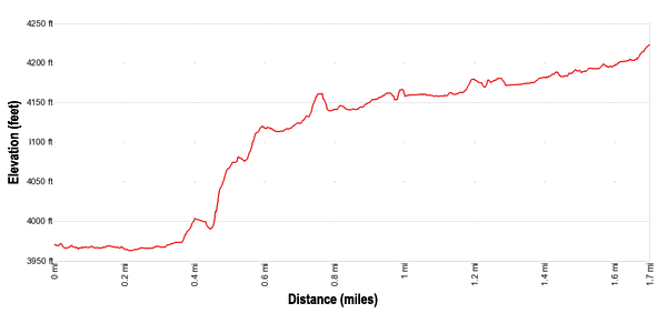
- Distance: 1.8 - 3.4 miles (RT)
- Elevation: 3,960-ft. at Trailhead
Maximum elevation - 4,225-ft. - Elevation Gain: 265-ft.
- Difficulty: moderate
- Basecamp: Moab
- Region: Southeast Utah
Trail Description - Moki Mesa
Note: This trail follows an unmarked, boot-beaten path that crosses sections of slickrock. There are no cairns or other markers to guide you. Experience with route finding is helpful. The cow trail ascending to the mesa has some exposure and is not recommended for anyone with a fear of heights. Use care and judgment in this area when hiking with children or anyone inexperienced with hiking in canyon country.
To the west of Moab the Colorado River flows through a beautiful gorge rimmed by sheer Wingate sandstone walls. The Potash Road travels along the north side of the river as it flows through the canyon, following a wide bend around Poison Spider Mesa to the north and the Behind the Rocks and Amasa Back plateaus to the south.
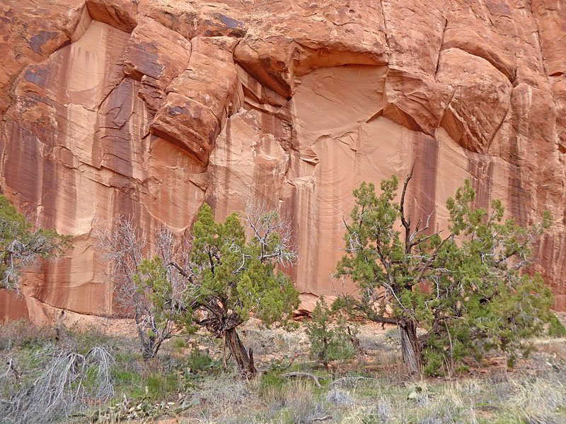
Moki Mesa is triangular bench located above the Potash Road but below the rim of Poison Spider Mesa. The undulating landscape is clad in grasses and scrub growth scattered with junipers and slickrock knobs. Along the eastern edge of the bench sheer cliffs streaked with desert varnish rise 200-400-ft. to the rim of Poison Spider Mesa. The Moki Mesa hike explores this secluded mesa.
From the unsigned pullout / parking area for Moki Mesa (see driving directions below), walk to the south end of the parking area where a trail heads east up a narrow side canyon, traveling through the trees and brush. The path initially stays near the base of the canyon’s south wall. Soon the path crosses the wash and views open up the canyon.
At 0.4 miles the canyon constricts and thick vegetation clogs the canyon floor. Look for a bypass trail branching left that climbs up to and then along a bench on the north side of the wash. If you miss the bypass and instead walk up the wash you will soon come to a pour-off which will require you to backtrack to the bypass trail.
The bypass trail offers fine views of the red rock amphitheater at the head of the canyon. After 0.1 miles the bypass trail reaches the top of the pour-off. Here the trail continues up wash. Just beyond the pour-off look right (south) to see a cow trail climbing on a diagonal up the south canyon wall. The trail is actually chiseled into the sheer sandstone wall.
Turn right and find a boot beaten path ascending through trees and scrub to the base of the cow trail. As you look up at the trail it is hard to imagine cows ascending this trail to reach the pastures atop Moki Mesa.
A short climb up the narrow cow trail soon leads to a slickrock bench atop Moki Mesa at 0.55 miles. Across the canyon to the north are nice views of sculpted slickrock walls and a large alcove.
One more climb is required to reach the pastures of Moki Mesa. At the top of the cow trail look to the left (south) to see a slickrock slope topped with a knob. A sheer red rock wall towers above the east side of the slope. A few trees and some scrub grow amid the rocky terrain at the base of the wall. I prefer ascending the slickrock slope, keeping to the left (east) of the slickrock knob. Hikers not comfortable on slickrock friction pitches can instead climb up the rocky terrain along the base of the wall.
Hikers ascending the slickrock bench will find the knob eventually forces them over to the trail coming up along the wall. The boot beaten path now continues ascending on easier grades along the cliff face. Above you the sheer walls are decorated with desert varnish.
Soon you will see an alcove where you will find some petroglyphs. Most are faded and hard to see. Please do not touch rock art panels as the oil on your fingers can speed the erosion of the rock art. Do not vandalize the panels or adding modern additions.
Beyond the alcove a short, steep rocky trail climbs to pass at 0.8 miles, located between the wall and a slickrock knob. At the top of the pass enjoy distant views of the cliffs rising above Bootlegger Canyon to the north. To the south are fine views of the slickrock walls towering above the scrub-clad pastures of Moki Mesa.
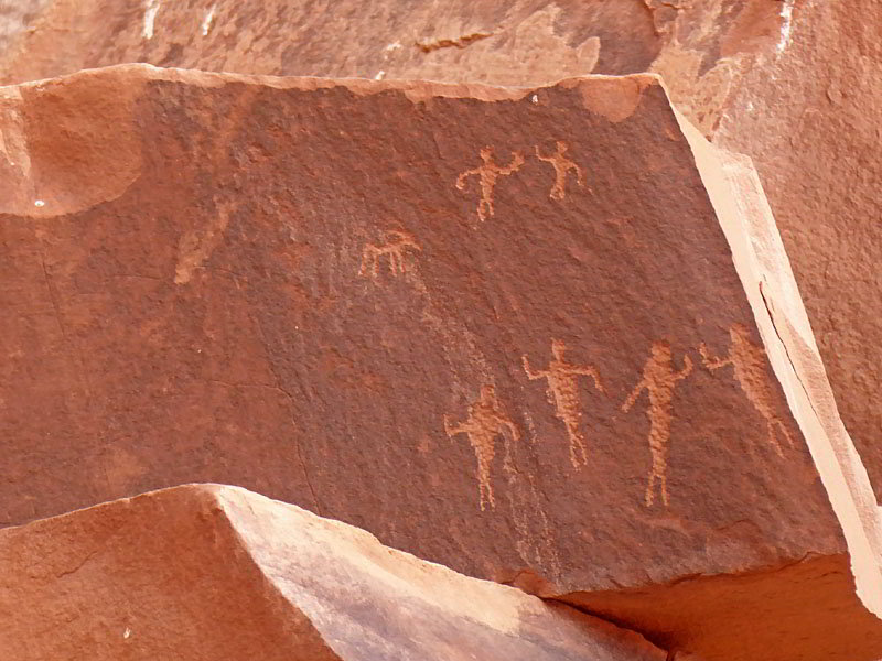
The path now descends a slickrock slope to the mesa floor and then travels along the base of the wall. Soon the path reaches a second alcove with more rock art at 0.9 miles. This is a good turn around point for parties looking for a shorter hike.
Hikers interested in further exploration of the Mesa can follow a boot beaten path which occasionally crosses slickrock. The trail typically stays along the wall except to circumvent obstacles like a rock fall at 1.1 miles. In some areas there are several possible paths. Use your judgment and try to stay off of any cryptobiotic soil.
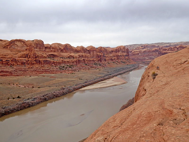
Near the end of the mesa the grass and scrub growth gives way to slickrock. Here you can easily walk over to the western edge of the mesa, high above the Potash Road, for great views of the Colorado River and the eroded cliffs of Amasa Back. Total distance to the overlook above the river is 1.7 miles.
When you are done enjoying the river views, retrace your steps back to the trailhead for a 3.4 miles (round-trip) hike. After dropping back into the canyon I strongly recommend turning right (east) and following the wash a short distance to see the amphitheater and pour-off at the head of the side canyon. During wet periods there is typically a pool beneath the pour-off. The side trip to the pour-off will add 0.25 miles to the day.
Elevation Profile
Driving Directions
Driving Directions From Moab: Drive north on US 191 N for 4 miles and turn left (southwest) on Utah 279 S / Potash Road. This turn is 1.3 miles north of the bridge crossing the Colorado River on US 191. Follow Utah 279 S for 9.4 miles and turn right (east) into an unsigned pullout/parking area and park. There is a no camping sign in the small parking area. The trailhead is located at the south end of the parking area.
If you reach the Corona Arch trailhead you have missed the pullout. If this happens, turnaround in the Corona Arch parking area and drive 0.4 miles back to the pullout on the left (east) side of the road.
Trail Resources
- Trail Photo Gallery
- Trail Maps
- Basecamp(s) Information: Moab
- Region Information: Southeast Utah
- Other Hiking Regions in: Utah