Details: Fuorcla Surlej to Pontresina 
Distance: 3.0 - 8.3 miles (one way)
near St Moritz in Eastern Switzerland
Hike Facts
- Distance: 3.0 - 8.3 miles (one way)
- Elevation: 8,855-ft. - 9,045-ft.
- Elevation Gain: 328-ft.
- Difficulty: moderate-strenuous
- Trail Highlights: See Trail Intro
- Basecamp(s): St Moritz
- Region: Eastern Switzerland

This quintessential Engadine hike is renowned for the dramatic views of glacier-clad Piz Bernina and Piz Roseg towering above Val Roseg. Lovely meadows, pretty larch forests and a rushing river add to the scenic delights on the descent to the valley floor and then Pontresina.
Murtel to Fuorcla Surlej

Distance from Trailhead: 3.0 miles (round trip)
Ending/Highest Elevation: 9,045-ft.
Elevation Gain: 328-ft.
Take the bus to Surlej, a small village to the southwest of St. Moritz, and then ride the Corvatsch cable car to the Murtel middle station (8,855-ft.). (See trailhead directions below). From Murtel enjoy splendid views of the Upper Engadine lakes plateau. To the west, Piz d’Emmat Dadaint, Piz Lagrev, Piz Polaschin and the Piz Julier tower above Lake Silvaplana (Silvaplanersee) and Lake Sils (Silsersee), nestled along the valley floor.
At Murtel find the hiking signs outside the lift station and walk in the direction of Fuorcla Surlej (1-hr), Chamanna Coaz (Coaz Hut) (3-hr) and Val Roseg (Roseg Valley) (2-hr 15-min). Follow the trail as it heads southeast, descending through an undulating landscape of talus slopes and rocky meadows along the north facing slopes of Piz Murtel. Fuorcla Surlej (Surlej Pass) is visible on the ridge to the east. The summits of Piz Tschierva and Piz Boval rise beyond ridge.
At 0.5 miles the trail climbs over the terminal moraine of the Corvatsch Glacier and then crosses a few small streams carrying meltwater from the rapidly receding ice sheet. Here views open to the top station for the Corvatsch cable car, situated atop a minor summit overlooking the Corvatsch Glacier. Soon the trail curves to the left (north) and starts climbing on moderate grades toward Fuorcla Surlej. As you ascend, enjoy nice views of the peaks rising along the west side of the Upper Engadine valley.
Reach Fuorcla Surlej at 1.5 miles. Here stunning views of Piz Bernina (13,280-ft.) and Piz Roseg (12,916-ft.), soaring above the east side of Val Roseg, burst onto the scene. The Tschierva Glacier cascades down the west face of the peaks. Piz Sella and Piz Gluschaint tower above the head of the valley blanketed by the Sella and Roseg glaciers. Berghaus Fuorcla Surlej, a restaurant, is located at the pass along with a small photogenic lake. The pass is a great destination for parties looking for a short, highly scenic hike.
Fuorcla Surlej to Pontresina

Distance from Trailhead: 8.3 miles (one way)
Ending/Highest Elevation: 9,045-ft.
Elevation Gain: -3,235-ft.
When you are done soaking in the views, hike south/southeast on the trail toward Val Roseg and Puntraschigna (the Romansh spelling of Pontresina). The path descends on moderate grades along the west side of Val Roseg to a junction at 1.7 miles. Turn left here toward Pontresina.
The trail to Pontresina descends steeply through meadows sprinkled with wildflowers in season. Switchbacks help ease the descent. Ahead are great views of the peaks towering above the north side of the Bernina Valley. The pyramid-shape peak is Piz Languard (10,702-ft./3,262-meters).
Munt Arlas (10,094-ft./3,107-meters) rises above the trail on the west side of Val Roseg. Across the valley, a high ridge rimming Val Roseg’s eastern flanks includes Piz Morteratsch Piz Boval, Piz Misaun and Piz Chalchagn.
Be sure to turn around for more great views of Piz Bernina, Piz Roseg and the Stella massif forming the massive cirque at the head of the valley. These views will continue to evolve and expand as you head down the valley.
At 2.25 miles pass above the buildings at Margun Surovel. Soon stunted trees appear amid the meadows. At 3.0 miles pass Alp Surovel. Beyond the alp the path travels through clusters of trees as it drops down switchbacks to Alp Roseg, home to the Hotel Roseggletscher (Hotel Roseg Glacier) (6,558-ft.), and a junction at 3.75 miles.
The Alp is a popular place, enjoys stunning views of the cirque at the head of the valley. Here you will find a restaurant along with house drawn carriage that ferry visitors between the Alp and Pontresina. Bikes are also prevalent, taking advantage of the relatively easy ride up the valley to the Alp.
When you are done taking in the scene, return to the junction and follow the broad path branching right (northeast) toward Puntraschigna (1-hr 45-min). At 4.0 miles cross a bridge over the Ova da Roseg (river). On the east side of the valley the path turns left (north) and briefly travels along a dirt road shared by walkers, horse carriages and bikes. At 4.5 miles leave the road, bearing left on the trail designated for walkers.
The walker's trail down the valley is lovely, traveling through meadows and a forest of larch and pine trees on the right (east) side of the valley. Typically, walkers can continue along the trail all the way to Pontresina. Recent landslides, coming down the slopes of Piz Chalchagn, have blocked the path. Hikers must now turn left at 5.5 miles and then travel along the road, which crosses a bridge at Alp Pruma.
Between Alp Pruma and Pontresina there are segments of hiker’s only trails that will get you off the road, but expect to be traveling on the road for much of the remaining time to Pontresina. Stay to the side of the road to allow the horse carriages and bikes to pass. The road is wide enough to accommodate everyone so this is not a problem. Along the way follow the signs to the Pontresina train station.
(In the future a new trail may be carved through the landslide, if so, continue along the forested path, following the signs to Pontresina and Pontresina Bahnhof.)
The walking along the road has some advantages, offering nice views to the high peaks at the head of the valley as well as the summits rising above Val Bernina to the north. Reach the Pontresina Bahnhof (train station) at 8.3 miles. Here you will find both buses and trains to St. Moritz, (see the trailhead directions), along with many other destinations in the valley.
The Pontresina train station is on the south side of Val Bernina’s main highway while the town of Pontresina is on the north side of the highway. To walk to Pontresina, turn right on the road (Via a la Staziun) running along the front of the train station. Follow the road as it crosses a river and then reaches a “Y” intersection. Bear right and ascend along road (Via Da la Staziun) as it crosses over the highway and then the River Flax. Continue up the road a short distance and cross Via Da Mulin. Just beyond turn right on a walkway (La Senda) that climbs to Via Maistra, the main street in Pontresina at 8.7 miles
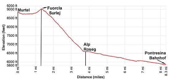
Elevation Profile
Driving Directions
St. Moritz Bahnhof to Surlej Corvatschbahn (Corvatch Cable Car in Surlej): In St. Moritz board a #1 bus bound for Sils/Segl Maria, Posta and get off at the Surlej, Corvatschbahn (Corvatsch Cable Car) stop. Alternatively, board a #5 bus bound for Sils/Segl Maria, Posta and change to a #20 bus at Silvaplana, Rundella Curtins bound for Surlej, Corvatschbahn. Check the Engadin Bus site, the SBB Website or the SBB App for more information on the buses and bus times and routes nearest your accommodations. The bus ride will take about 25 minutes depending on the connections. At Corvatschbahn, purchase a ticket to Murtel, the middle station for the cable way. Note: On the SBB site the Corvatsch Cable car is Surlej, Corvatschbahn.
Pontresina Bahnhof (train station) to St. Moritz Bahnhof: At the train station you can take either a bus or a train back to St. Moritz. The train is shorter but the buses run more frequently. The #4 bus goes directly to the St. Moritz Bahnhof whiles other buses, like the #2 bus, will require changes at St. Moritz Schulhausplatz to a #1 bus the train station. Check current train and bus information for the current route and times on the SBB Website or the SBB App. The train ride takes about 17 minutes while the buses take 25-40 minutes, depending is you need to change buses.
Trail Resources
Trail Intro / Trail Photo Gallery / Trail Map
Basecamp(s) Information:
St Moritz
Region Information:
Eastern Switzerland
Other Hiking Regions in:
Switzerland