Schachentaler Windgallen
This scenic hike, traveling through lovely meadows, along rugged cliffs and beside rushing streams, features great views of the high peak rimming the Schächental Valley, the beautiful alps of Chammli, Oberalp and Äsch and dramatic Stauben Falls.
- Distance: 7.0 miles (One Way)
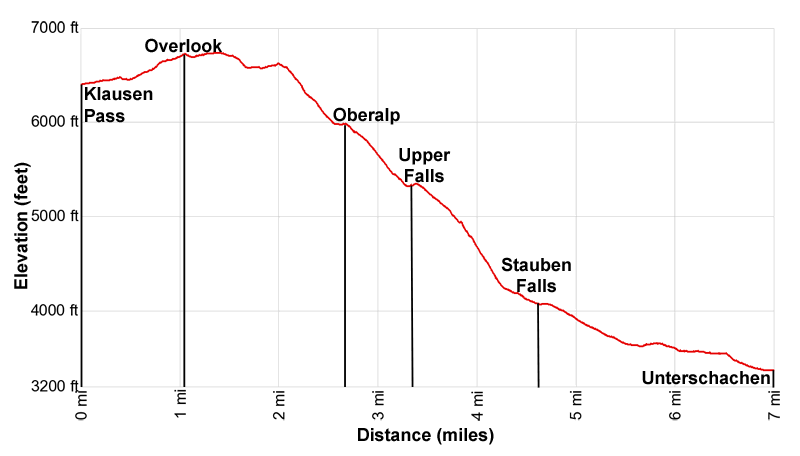
- Elevation: 6,400-ft. at Trailhead
Maximum elevation - 6,740-ft. - Elevation Gain: 340-ft.
- Difficulty: moderate
- Basecamp: Altdorf
- Region: The Bernese Oberland
Trail Description - Klausen Pass – Äsch – Unterschächen
Get off the beaten path with this scenic hike along the less traveled south side of the Schächental (Schächen Valley). From Klausen Pass the trail climbs to a panoramic viewpoint above alp Chammli before descending steeply through an interesting landscape of meadows and cliffs to Oberalp and then Äsch where Stauben Falls plunges down rugged cliffs.
Along the way great views encompass the high summits rimming the both side of the upper Schächental and stretch down the length of the valley to the peaks towering above the west side of Altdorf and the Reuss Valley. Wildflowers, rugged cliffs and rushing streams add to the scenic delights.
This trail should not be confused the Schächental Höhenweg, a panoramic trail traveling high above the north side of the Schächental. If you are new to the area do the Schächental Höhenweg first. It is the better hike. If you are a returning visitor then this hike is a terrific alternative that allows you to visit a less traveled part of the beautiful Schächental.
To Äsch and Unterschächen
Note: The cumulative elevation gain and loss for the hike is +340-ft / -3,400-ft (+104-meters / -1,036-meters).
Klausen Pass (6,400-ft.), a relatively low pass between Linthal and Altdorf, is crossed by a popular road. Regularly scheduled Postbuses climbing to the pass facilitate this scenic point-to-point hike. (See trailhead directions below for more information.)
From Klausen Pass find the paved path on the south side of the highway, just to the west of the chapel (Kapelle Bruder). Walk south on the path to a set of trail signs. To the right (west) is a path leading to Untere Balm, Spiringen and Biel, part of the Alpine Pass Route and the Schächental Höhenweg, along with the low route to Äsch (via Balmwand). Our trail continues straight ahead (south) toward Oberalp, Äsch and Unterschächen.
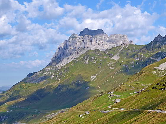
The paved path quickly gives way to a gravel track/alp road that ascends west on easy grades accompanied by fine views of the Schächentaler Windgallen towering above the north side of the Schächental. The Marcher Stockli and its rugged ridges loom above Klausenpass. To the west are distant views of the high peaks, including the Uri Rotstock, Brunnistock and Blackenstock, rising above the west side of Altdorf and the Reuss Valley.
At 0.4 miles (0.6 km) reach a switchback on the track. Here we leave the road and continue straight ahead on a trail that ascends on moderate grades through rocky meadows. The path passes a small barn and then rejoins the track at 0.8 miles (1.3 km).
After 1.0 mile (1.6 km) the grade abates as the path curves to the left (south), reaching the high point of the hike. From this vantage point beautiful views extend down the length of the Schächental to the summits rising above the Reuss Valley. The Schächentaler Windgallen dominates the view to the northwest. To the south the glacier-clad Scharhorn, Chli Ruchen and Gross Windgallen rim the Schächental.
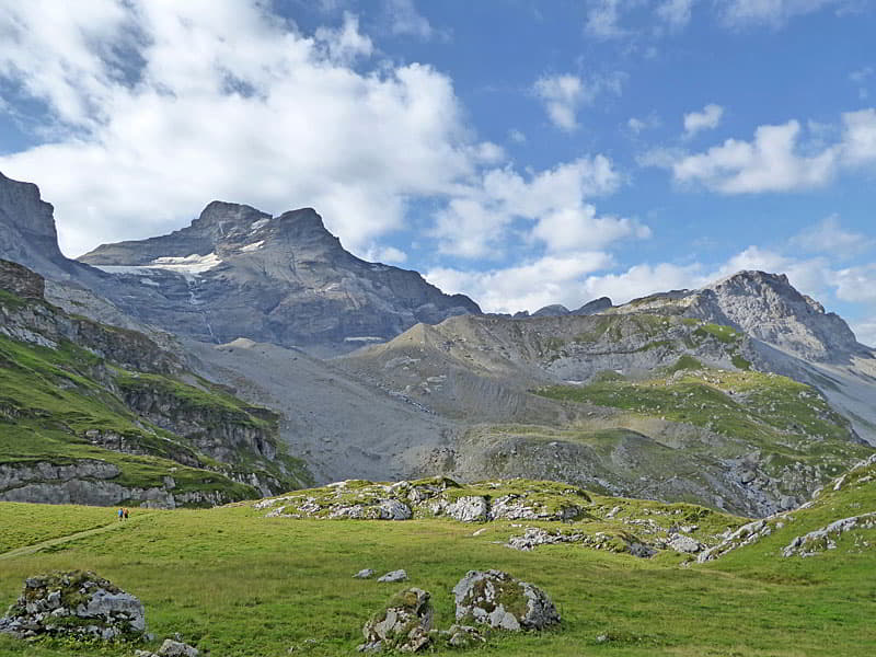
After enjoying the scene follow the path as it drops on easy grades through meadow sprinkled with wildflowers toward Alp Chammli. As you descend the Chammliberg joins the scene, rising to the east of the Scharhorn.
The path soon passes the alp buildings and then descends to a scree field spilling down the slopes of the Scharhorn and Chammliberg at 1.75 miles (2.8 km). Here the path curves to the right (west), crosses the scree field and then a bridge over the Staubenbach, a stream carrying glacial meltwater. Beyond the bridge the trail soon reaches an overlook with stunning views down the length of the Schächental. Below us are the expansive meadows of Oberalp.
The path now plunges down a very steep slope. Switchbacks facilitate the descent through meadows and cliffs. Chains bolted to the rockface offer hand holds and a level of security along slightly exposed sections of the trail. Take a few breaks on the descent to enjoy the terrific views.
After half a mile (0.8 km) the grade abates and then reaches a junction at Oberalp at 2.6 miles (4.2 km). The junction is adjacent to ponds and a marshy area. Here the trail to the left leads to Oberalp (10 min) and the top of a lift dropping to Äsch. (Taking the lift down to Äsch will eliminate about 2.0 miles (3.2-km) and 2,000-ft. (610-meters) of elevation loss.) This trail also connects with paths leading to Nideralp, Wannelen, Brunni and Unterschächen. (At Wannelen a second lift descends to Ribi, located a short distance from Unterschächen).
We turn right on the trail toward Äsch and Unterschächen, which descends on steep grades down a narrow valley clad in rocky meadows and shrubs. The path soon crosses to the east side of the small stream cascading down the valley floor. Near the bottom of the drainage views open to the steep cliffs below Chammlialp.
Shortly after crossing back to the west side of the stream the grade abates as the trail reaches a lower bridge over the Staubenbach at 3.25 miles (5.2 km). Beyond the bridge look up to see upper Staublifall (Stauben Falls) gushing down the cliffs below Chammlialp. Early in the season this is an impressive waterfall.
The path now resumes its steep descent on a rocky trail traveling along the base of the cliffs beneath Chammlialp. Soon the meadows give way to forested slopes with intermittent meadows. Openings offer nice views of the ridge rising above the north side of the Schächental and a waterfall spilling down the slopes beneath the Klausen Pass road.
At 3.7 and 3.9 miles (6.0 and 6.3 km) ignore the trails branching right. The second trail is marked for the path climbing to Klausen Pass via the Balmwand trail, which we passed near the start of the hike. We continue our steep descent toward Äsch and Unterschächen.
Past the second junction the path curves to the left (northwest and then west). Here we leave the trees behind and enter the pastures above Äsch. At 4.2 miles (6.8 km) the trail crosses the Niemerstafelbach, a stream, where the grade moderates. Here views extend down the valley to the Spitzen, rising above the Brunnital, the valley extending south from Unterschächen.
A short distance beyond, the trail nears a bench set on a hill above Äsch. Take the short spur trail to the bench and enjoy the beautiful views of Äsch, set amid emerald green meadows, and the Staublifall plunging down the cliffs above village.
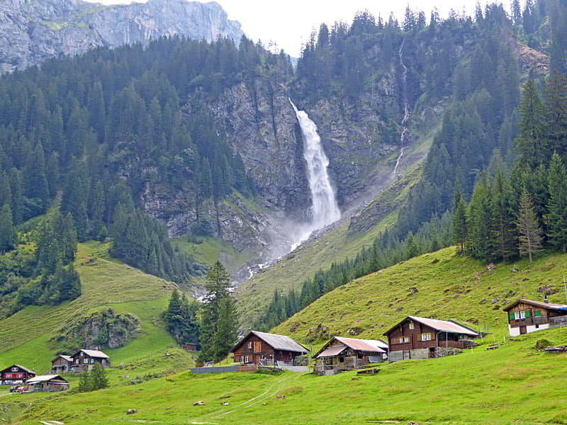
After a break, return to the trail which now drops down to a wide track. Turn right and follow the track as it descends on gentle grades through the village. At 4.6 miles (7.4 km) the track crosses a wood bridge over the Stuabenbach accompanied by great views of the falls. Turn around for great views of the cliffs beneath Chammlialp.
Beyond the bridge the track soon arrives at trail signs near a restaurant and the bottom station for the old fashioned cable car between Äsch to Oberalp. Here signs point down valley (west) toward Ribi (45 min) and Unterschächen (1hr).
The trail now follows the alp road down the deep “V-shaped” Schächental, descending on easy to moderate grades through forests and meadows. Openings offer views of the steep slopes rising above the north side of the valley, small alps set amid meadows and the Vorder Schächen river tumbling down the valley floor.
At 6.4 miles (10.3 km) reach Ribi, a small hamlet where another old-fashioned cable car takes passengers up to Wannenlen. We continue toward Unterschächen (20 min). At the south end of Ribi the track briefly joins a pavement, heading west along the south side of the road to Klausen Pass. A short stint along the road leads to a trail that makes a quick descent down a hill to a track. The track descends on easy grades through pastures to Unterschächen where the trail once again travels on a pavement along the south side of the Klausen Pass Road. At 6.9 miles (11.1 km) reach an intersection where the main road up the Brunnital branches left. The intersection offers a good place to cross to the north side of the road and then continue west to the Unterschächen Post bus stop at 7.0 miles (11.3 km) where our hike ends. There are several restaurants and a grocery store where you can find snacks and drinks while you wait for the next bus to Altdorf.
Elevation Profile
Driving Directions
From Altdorf to Klausen Pass: From Altdorf catch the #408 bus at Telldenkmal, the main square in the center of town, to Klausen Passhole (Klausen Pass). If starting from the Altdorf train station take a bus bound for Brugg and then change at Telldenkmal for the #408 bus to the pass. Check the schedule before setting out. Given the length of this hike it is best to catch an early bus. The ride to the pass takes about 55 minutes.
Bus schedules are posted at the bus stops or are available online at the SBB website and the SBB app. When looking for buses use “Altdorf UR, Telldenkmal”, the UR in the name stands for the canton of Uri.
From Unterschächen to Altdorf: At the Unterschächen Post Bus stop, take the #408 bus in the direction of Attinghausen, Seilbahn to Altdorf, Telldenkmal. This bus also stops at the Altdorf train station. The bus schedule is posted at the bus stop and are also available online at the SBB website and the SBB app.
Trail Resources
- Trail Photo Gallery
- Trail Maps
- Basecamp(s) Information: Altdorf
- Region Information: The Bernese Oberland
- Other Hiking Regions in: Switzerland