Eiger Trail 
Distance: 3.8 - 8.5 miles (round trip)
Bernese Oberland, near Grindelwald in The Bernese Oberland
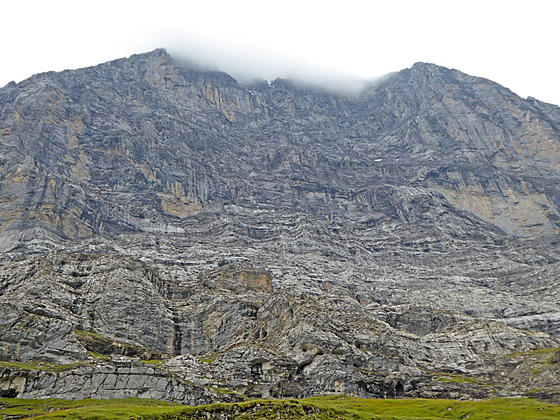
The Eiger partially covered by a cloud
This interesting hike travels along the base of the Eiger with up-close and dramatic views of the iconic peak's sheer north face along with fine views of the Grindelwald Valley and nearby summits. Several options extend the hike, adding to the scenic delights of the day.
See Trail Detail/Full Description
- Distance: 3.8 miles (one way)
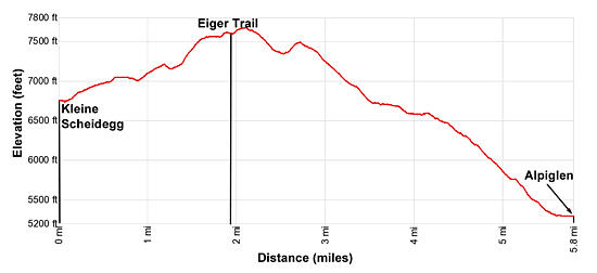
- Elevation: 6,762-ft. at Trailhead
Maximum elevation: 7,612-ft. - Elevation Gain: -2,369-ft.
- Difficulty: moderate
- More Hikes in:
Grindelwald / The Bernese Oberland
Why Hike Eiger Trail
The popular Eiger Trail descends beneath the soaring north face of the Eiger (13,025-ft.) accompanied by panoramic views of the Grindelwald Valley, Kleine Scheidegg and the Lauberhorn. The 3.8 mile trail starts at the Eigergletscher Train Station to the southeast of Kleine Scheidegg, a saddle on the ridge separating the Lauberhorn and the Eiger. (See trailhead directions below).
There are several ways to reach the Eiger Trail. Hikers can take the Eiger Express from the Terminal station in Grindelwald to the Eiger Station. Alternatively, reach the trailhead by taking the train/cog railway from either Grindelwald or Lauterbrunnen to Kleine Scheidegg and then switch to the Jungfrau Railway and get off at the first stop, the Eiger Station.
Kleine Scheidegg is a very busy place, filled with tourists jostling to catch trains to various destinations. If time and energy permit, I strongly suggest walking from Kleine Scheidegg to the start of the Eiger trail, a 1.4 to 1.9 mile hike (described below) resulting in a 5.7 mile point-to-point trip that ends at the Alpiglen rail station.
Hikers looking for a longer day can combine Hike 47 - Panoramaweg: Mannlichen to Kleine Scheidegg trail with the Eiger trail for a highly scenic 8.5 mile point-to-point hike. More information on this alternative is found at the end of the hike description.
The trail can be quite slippery if snow is present, requiring the use of microspikes. Check at the Grindelwald tourist office for current conditions.
The Eiger trail can be walked in either direction. Some parties walk up from Alpiglen to help acclimate and get into condition. The trail is rated as moderately-strenuous if you walk uphill. I personally prefer to walk down so the best scenery it right in front. Whatever way you walk it is a great hike.
Elevation Profile
| Support our Site |
Trail Resources
Trail Detail/Full Description / Trail Photo Gallery / Trail Map
Basecamp(s) Information:
Grindelwald
Region Information:
The Bernese Oberland
Other Hiking Regions in:
Switzerland