Grosse Scheidegg to Bussalp 
Distance: 3.5 - 8.9 miles (one way)
near Grindelwald in The Bernese Oberland
The Schreckhorn, Finsteraarhorn, Fiescherhorn massif and the Eiger
Panoramic views of the 4,000-meter peaks, glacial cirques and deep gorges to the south of Grindelwald are the highlights of this terrific hike between Grosse Scheidegg and Bussalp.
See Trail Detail/Full Description
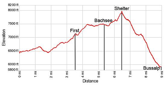
- Distance: 3.5 miles (one way) to First
5.4 miles (one way) to Bachsee
8.9 miles (one way) to Bussalp (Complete Hike) - Elevation: 6,452-ft. at Trailhead
7,110-ft. at First
7,450-ft. at Bachsee
5,905-ft. at Bussalp (Complete Hike) - Elevation Gain: 658-ft. to First
998-ft. to Bachsee
-2,001-ft. to Bussalp (Complete Hike) - Difficulty: moderate-strenuous
- More Hikes in:
Grindelwald / Meiringen / The Bernese Oberland
Why Hike Grosse Scheidegg to Bussalp
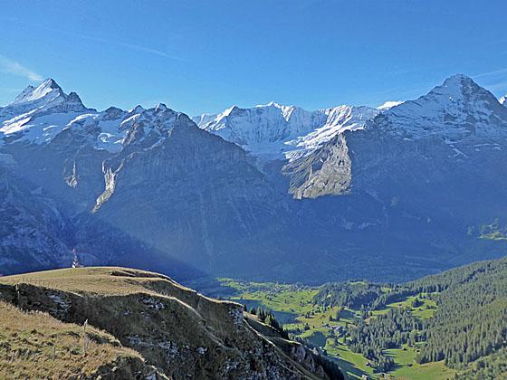
From various viewpoints in Grindelwald, the sheer north faces of the Wetterhorn, Mattenberg and Eiger, split by deep glacial gorges, soar above the south side of the valley. Hidden from this perspective are an amazing set of 4,000-meter peaks, including the Schreckhorn, Fiescherhorn and the Finsteraarhorn.
This scenic hike, traveling from Grosse Scheidegg to Bussalp, features magnificent panoramic views of all these peaks and more from a variety of different angles. Along the way the path passes the photogenic Bachsee, traverses rugged ridges and travels through lovely, wildflower-filled meadows.
Starting in Grosse Scheidegg, hikers are treated to intimate views of the Wetterhorn towering overhead along with side views of the Mattenberg, Monch and Eiger. As the trail traverses the base of the Schwarzhorn views open to the Schreckhorn and Klein Schreckhorn, rising along the ridge above the Mattenberg. Soon the Fiescherhorn massif makes an appearance, towering above Fiescher glacier nestled in a bowl behind the Eiger.
At the First viewpoint we are treated with dazzling views of the Grindelwald Glacier, tumbling in motionless waves down the slopes of the Wetterhorn, Barglistock and Schreckhorn. The Finsteraarhorn rises beyond the glacial cirque formed by the Fiescherhorn, Monch and Eiger.
From First the trail ascends to the Bachsee, where the Wetterhorn and Schreckhorn form the perfect backdrop for this pretty little lake. Our path now turns south and we leave the majority of hikers behind as the trail climbs along the eastern flanks of Reeti to Spitzen, with splendid panoramic views of the Finsteraarhorn soaring above the Obers Ischmeer Glacier.
Soon the trail turns southwest again, crosses Reeti’s southeast ridge and then traverses along the peak’s south face with terrific views looking directly into the deep glacier carved gorges to the south of Grindelwald. Above the gorges the Grindelwald, Ischmeer and Fiescher Glaciers lie cradled in rugged cirques and spill down the flanks of Grindelwald’s high peaks. To the southwest the Jungfrau, Breithorn and Tschingelhorn form the backdrop for Kleine Scheidegg, the saddle on the ridge between the Eiger and Mannlichen. As the trail nears Bussalp the Eiger, Monch and Jungfrau dominate the views to the southwest and we see the Wetterhorn, Schreckhorn and Fiescherhorn from a new angle.
While it is possible to walk to Grosse Scheidegg to start the hike, I strongly recommend taking the bus so you can get an earlier start. Clouds frequently form in the afternoon, obscuring the view of the high peaks.
Beyond First there is no place for refreshments along the trail until you reach Bussalp. Hikers are advised to carry water, lunch and snacks.
Elevation Profile
| Support our Site |
Trail Resources
Trail Detail/Full Description / Trail Photo Gallery / Trail Map
Basecamp(s) Information:
Grindelwald / Meiringen
Region Information:
The Bernese Oberland
Other Hiking Regions in:
Switzerland