Details: Obersteinberg Loop 
Distance: 6.7 - 10.2 miles (loop)
Bernese Oberland, near Lauterbrunnen in The Bernese Oberland
Hike Facts
- Distance: 6.7 - 10.2 miles (loop)
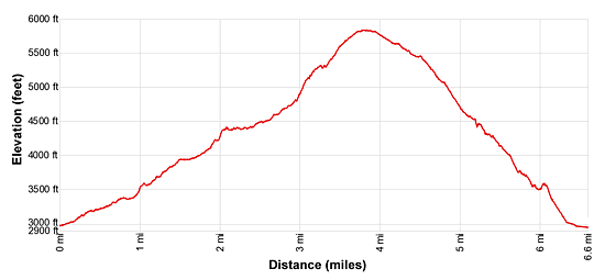
- Elevation: 2,985-ft. - 5,833-ft.
- Elevation Gain: 2,880-ft.
- Difficulty: strenuous
- Trail Highlights: See Trail Intro
- Basecamp(s): Lauterbrunnen
- Region: The Bernese Oberland
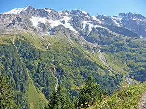
This loop hike travels to Obersteinberg, a pretty alp with impressive views of the glacier-clad summits rimming the head of the Lauterbrunnen Valley. Views stretch from the Jungfrau in the north to the Breithorn and Tschingelhorn in the south. Extend the hike with a trip to the Oberhornsee, a small lake.
Valley Trail from Stechelberg to Obersteinberg
Distance from Trailhead: 3.8 miles (one way)
Ending/Highest Elevation: 5,833-ft.
Elevation Gain: 2,880-ft.
The last stop on the bus from Lauterbrunnen to Stechelberg is just to the north of the Stechelberg Hotel (see trailhead directions below). Walk south (up valley) along the main road past the hotel. At the next two intersections stay to the east of the Weisse Lutschine River on the broad track toward Trachsellauenen, Obersteinberg and Schmadrihutte. Don’t cross the bridges over the river.
Past the second junction the trail ascends on moderate grades through pastures and clusters of trees beside the river with views of the high peaks, including the Mittaghorn, Grosshorn and Breithorn, towering above the east side of the valley. At 0.6 miles continue toward Trachsellauenen by crossing a bridge to the west side of the river.
On the west side of the river the trail crosses a broad track (alp road) several times as it ascends on moderately-steep grades through forests and intermittent meadows, cutting off several long switchbacks on the road. Watch for signs that say “Wanderweg” to stay on track. At trail intersections always follow the trail toward Trachsellauenen and Obersteinberg.
Reach the Berghaus Trachsellauenen and then the junction at Trachsellauenen at 1.6 miles. Do not cross the river, instead bear right on the trail toward Bergwerk and Obersteinberg. The grade briefly abates as the path travels beside the river along the base of an avalanche chute. Ahead are fine views of the Breithorn and Grosshorn towering above the head of the valley.
At 1.8 miles the trail enters the trees and reaches a plaque marking the site of the former lead, silver and barite mines at Trachsellauenen. Beyond the mine site the path reaches a somewhat confusing intersection at Bergwerk with signposts pointing in two directions to Obersteinberg. The trail to the right climbs very steeply to the Hotel Tschingelhorn and then Obersteinberg. I recommend the trail to the left toward Schirboden and Obersteinberg that continues up the valley on more reasonable grades and takes the same amount of time.
The trail to the left initially climbs on steep grades that soon moderate as it reaches a second junction. Here a trail branches left to Schmadrihutte. Our trail to Obersteinberg continues its ascent through trees along the west side of the river.
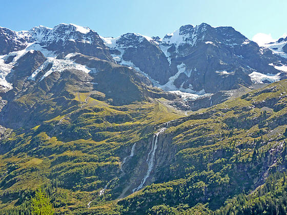
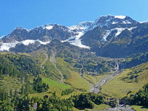
At 2.2 miles views open to a rocky avalanche chute on the slopes of the Mittaghorn. A short distance beyond the trees give way to meadows and views open to high peaks rimming the valley to the southeast. Beautiful Schmadri Falls tumbles down the steep cliffs below the Breithorn. As you climb turn around for fine views of the Jungfrau towering above the valley to the northeast.
At 2.6 miles, pass through the small alp at Schirboden. Ignore the trail branching left to a viewpoint for Holdrifalle (Holdri Falls) and Lager. The grade now steepens and reenters the trees. At 2.8 miles a second detour, again branching left, heads to Talbachfall (Talbach Falls). We keep ascending on the Bergwanderweg (trail) toward Obersteinberg.
A stiff climb soon leads to the junction at Wilde Egg where we bear right toward Obersteinberg. (The trail to the left heads to Tal and the Oberhornsee.) Openings in the trees along the steep ascent offer lovely views of Schmadri Falls and the Grosshorn.
At 3.5 miles the trees give way to meadows and terrific views open to the high peak to the east along with the Breithorn and Tschingelhorn towering above the head of the valley. Reach Obersteinberg (5,833-ft.) and a junction at 3.7 miles. To the left is the trail to the Oberhornsee, a small lake. Turn right and reach the Hotel Obersteinberg at 3.8 miles. The circa 1880 hotel offers private rooms and dormitory accommodations along with a restaurant.
Obersteinberg is a superb overlook with stunning views of the cirque at the head of the valley and the wall of summits, including the Jungfrau, rimming the valley’s east wall. I recommend returning to the junction with the trail to the Oberhornsee and then walking a short distance toward the Oberhornsee to a splendid viewpoint with front row seats for beautiful Schmadri Falls dropping 1,000-ft. from the lip of a hanging valley. The glacial cirque ringing the head of the valley towers above the falls. Visiting the viewpoint adds 0.5 miles (round trip) to the hike.
From Obersteinberg hikers can either retrace their steps to the trailhead for a 7.6 mile round-trip hike or turn the hike into a loop by returning via the west side of the valley (the high route), which is shorter but steeper. My preference is the loop. See the description of the high route below for more information.
Parties with the time and energy can extend the hike with a side trip to the Oberhornsee, a small lake situated in the rocky meadows between the moraines of the Breithorn and Tschingelhorn Glaciers.
Obersteinberg to Oberhornsee

Distance from Trailhead: 3.5 miles (round trip)
Ending/Highest Elevation: 6,775-ft.
Elevation Gain: 940-ft.
The trail to the Oberhornsee begins at the “Y” intersection to the south of the Obersteinberg Hotel. Take the trail branching right toward the Oberhorn and Oberhornsee that ascends along the right (west) side of the valley. At 1.0 mile the path crosses a bridge over the Tschingel stream carrying meltwater from the Tschingelfirn glacier. Beyond the bridge the trail climbs steeply to a bench and the Oberhornsee (6,775-ft.), a small lake, after gaining over 940-ft in 1.75 miles.
The lake enjoys spectacular views of the Breithorn, Tschingelhorn, Gspaltenhorn and the Ellstabhorn anchoring the cirque at the head of the Lauterbrunnen Valley. The Jungfrau dominates the view to the north. After enjoying the lake, retrace your steps to Obersteinberg for a 3.5 mile round trip hike extension.
Obersteinberg to Stechelberg via the High Route
Distance from Trailhead: 6.7 miles (loop)
Ending/Highest Elevation: 2,985-ft.
Elevation Gain: -2,880-ft.
To take the high route back to Stechelberg, return to the junction at Obersteinberg. Head northeast on the trail toward the Hotel Tschingelhorn and Stechelberg, that travels by the Hotel Obersteinberg and then descends through high meadows on the west side of the valley. Along the way enjoy great views of the glacier-clad peaks across the valley. Initially the trail descends on easy grades but soon the grade steepens.
Pass the Hotel Tschingelhorn at 4.4 miles. Beyond the hotel the trail descends on very steep grades. At 4.9 miles the path enters the trees and loses the views. Reach a junction at 5.9 miles and take the trail headed toward Stechelberg, Gimmelwald and Murren.
Reach a junction at Schwendiwald (3,740-ft.) at 6.1 miles. Turn right (northeast) toward Stechelberg on a trail that drops down a series of steep switchbacks to the valley floor. (The other trail climbs toward Gimmelwald and Murren.) Cross a bridge over the river to the east side of the valley at 6.5 miles and then turn left, following the broad track through the village to the bus stop at the Hotel Stechelberg (2,985-ft./910-meters) at 6.7 miles.
Note: If you return to Stechelberg via the Valley Trail add 0.9 miles to the trail mileage for a 7.6 mile (round-trip) hike or a 11.1 miles hike if you include the optional extension to the Oberhornsee.
Elevation Profile
Driving Directions
Lauterbrunnen Bahnhof to Stechelberg Hotel (last stop): Walk to the Lauterbrunnen Bahnhof bus stop, located at the north end of the station along the west side of the main road. Catch the #141 bus bound for Stechelberg (last stop). The ride should take about 20 minutes. There are a number of stops to catch the bus along the main road through Lauterbrunnen. Check the SBB website or download the SBB app for the current schedule and nearest stop.
From Stechberg Hotel to the Lauterbrunnen Bahnhof (last stop): Walk north past the Stechelberg Hotel to the large parking lot and bus stop. Catch the #141 bus bound for the Lauterbrunnen Bahnhof. The ride should take about 20 minutes. The bus makes a number of stop along the main road through the village. Check the SBB website or download the SBB app for the current schedule and the stop nearest to your destination.
Trail Resources
Trail Intro / Trail Photo Gallery / Trail Map
Basecamp(s) Information:
Lauterbrunnen
Region Information:
The Bernese Oberland
Other Hiking Regions in:
Switzerland