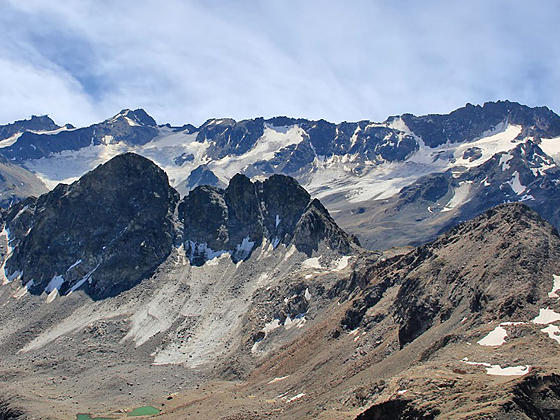
Piz Sarsara, Piz Vadret, the Grialetsch Glacier and Piz Radont
Hike to the summit of the Schwarzhorn for splendid, panoramic views of the high peaks in the northeast Graubunden area and beyond. The Schwarzhorn is considered to be one of the easier 3,000-meter peaks to ascend in the Swiss Alps.
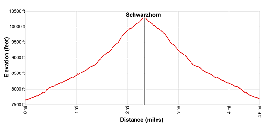
- Distance: 4.6 miles (RT)
- Elevation: 7,817-ft. at Trailhead
Maximum elevation - 10,318-ft. - Elevation Gain: 2,501-ft.
- Difficulty: killer
- Basecamp: Davos
- Region: Eastern Switzerland
Trail Description - Fluela Pass to the Schwarzhorn
Far reaching, 360-degree views of the high peaks in the Lower and Upper Engadine Valleys and the summits towering above the Davos area and beyond are the highlights of the hike to the summit of the Schwarzhorn. The steep trail is recommended for hikers with the stamina and conditioning to ascend 2,500-ft. in 2.3 miles. Many consider the summit to be one of the most accessible of the 3,000-meter peaks in the Alps.
The hike, starting near Fluela Pass, climbs up the west side of a beautiful cirque anchored by Piz Radont, the Raduner Rothorn and the Schwarzhorn. The stiff climb travels through meadows, scree covered slopes and then the Schwarzhorn’s rugged southeast ridge to the summit. The ridge includes a slightly exposed trail section that soon widens.
Pick a beautiful day and get an early start to enjoy the views. Extend the day by turning the hike into a point-to-point journey to Durrboden in the lovely Dischma Valley. See the Fluela Pass – Schwarzhorn - Durrboden hike for more information.
(Note: The Schwarzhorn in Davos is often referred to as the Fluela Schwarzhorn to distinguish the peak from the Schwarzhorn in the Valais.)
Hiking to the Schwarzhorn
Start the day by taking the bus from Davos to the Schwarzhorn trailhead, located along the Fluelapass (Fluela Pass) road. (See trailhead directions below.) Get off the bus at the first stop after Fluelapass (east side of the pass). The stop and the trailhead are located along the south side of the road.
Note for hikers driving to the trailhead: There is limited parking at the trailhead. If the lot is full, turn around and park at Fluela Pass. A 0.6 mile (one-way) trail, traveling above the north side of the Fluelapass Road, leads to the Schwarzhorn trailhead. Follow the trail signed for the Schwarzhorn, Fuorcla Radont, Grialetschhutte and Durrboden. This description assumes you are starting at the bus stop. If starting at the pass, add 0.6 miles (one-way) to the mileage in the description below.
At the trailhead, walk southeast on the trail signed for Schwarzhorn, Fuorcla Radont, Grialetschhutte and Durrboden. The trail immediately starts climbing on moderately-steep to steep grades through rocky meadows and intermittent scree. Along the way pass a junction with a trail branching left. We continue on the trail to the Schwarzhorn. Behind you (north) the Fluela Wisshorn towers above the Fluelapass road.
At 0.3 miles the trail climbs a few steep switchbacks and then swings to the right (southwest), entering the Radont Valley rimmed with a cirque anchored by Piz Radont, the Raduner Rothorn and the Schwarzhorn. The path now ascends on moderately-steep to steep grades beneath the east facing slopes of the Schwarzhorn accompanied by great views of Piz Radont to the south.
Reach a junction at 0.5 miles with a trail branching left (south) toward Fuorcla Radont and the Grialetschhutte. We continue on the trail to the Schwarzhorn.
Beyond the junction views open to the Raduner Rothorn and Fuorcla Radont (Radont Pass), the saddle on the ridge to the northeast of Piz Radont. Soon the Schwarzhorn (10,318-ft.) joins the scene. Below the trail a stream winds down the valley floor.
At 1.0 mile the path starts climbing switchbacks. Soon the meadows give way to scree covered slopes. Turn around occasionally to appreciate the fine views stretching northeast to Piz Linard and the peaks towering above the Fluelapass Road and the Lower Engadine Valley.
The grade steepens as the path ascends tight switchbacks up the rugged slopes beneath the Schwarzhornfurgga (Schwarzhorn Pass). Here views open to the Schwarzhorn’s south ridge, the route to the summit.
At 1.6 miles reach a junction with a trail branching left (east) toward Fuorcla Radont. Large rocks around the junction provide convenient resting places before continuing the ascent.
After taking a break continue straight ahead toward the Schwarzhorn, reaching the Schwarzhornfurgga at 1.75 miles. From the pass views stretch west to the high peaks rimming the Dischma Valley and beyond. Behind you the summits rising above the Lower Engadine valley fill the skyline.
Turn right and follow the trail as it climbs very steep switchbacks up the south ridge to the summit of the Schwarzhorn (10,318-ft.) at 2.3 miles. Initially the trail has some minor exposure but soon the ridge widens and the remainder of the stiff climb to the top is on a good, albeit very steep, trail.
From the summit enjoy breathtaking, panoramic views that extend northwest down the Dischma Valley to Davos. The Fluela Wisshorn towers above Fluela Pass to the north. Piz Linard soars above a sea of peaks rising above the Lower Engadine Valley to the east. The Piz Sarsura massif, Piz Vadret and the Grialetsch Glacier are seen beyond Piz Radont to the south. Piz Kesch, the Porchabella Glacier and the summits rimming the upper Dischma, Funtauna and Tschuvel valleys grace the skyline to the southwest.
When you are done taking in the views retrace your steps to the trailhead for a 4.6 miles round-trip hike. Parties looking for a longer day can return to the junction with the trail to Fuorcla Radont at 3.0 miles. From here you can hike to Fuorcla Radont in 1.25 miles and then take the trail descending the east side of the Radont valley back to the trailhead for a 6.4 mile hike. Alternatively, continue over Fuorcla Radont to Durrboden for an 8.1 mile hike. See the Fluela Pass - Schwarzhorn - Durrboden hike for more information.
Elevation Profile
Driving Directions
From the Davos Dorf Bahnhof: Take the #331 bus heading toward Susch and get off at Susch, Abzw. Schwarzhorn. (Abzw. is an abbreviation for Abzweigung or junction.) This is the first stop after Fluela Pass (east side of the pass). The trailhead is located on the south side of the highway. The ride should take 24 minutes. You can check the current schedules at the SBB website/SBB app.
Note: If you are driving, there is limited parking at the trailhead. If the lot is full, turn around and park at Fluela Pass. From the pass, locate the trail at the northeast end of the parking area. The trail traverses the north side of the Schwarzsee, a lake, and then travels along the slopes above the north side of the highway to the Schwarzhorn trailhead in 0.6 miles.
Trail Resources
- Trail Photo Gallery
- Trail Maps
- Basecamp(s) Information: Davos
- Region Information: Eastern Switzerland
- Other Hiking Regions in: Switzerland