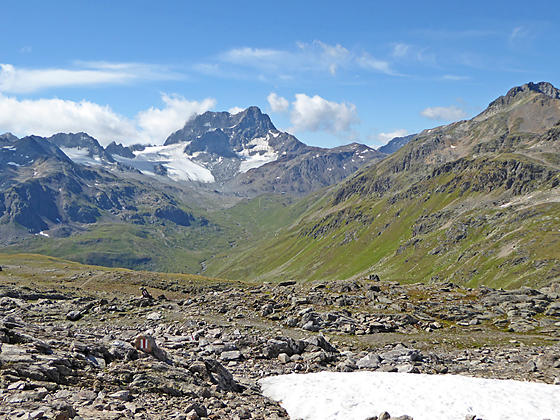
Piz Kesch and Piz Forum from Sertig Pass
Ascend a bucolic valley and then scree-covered slopes to scenic Sertig Pass with terrific views of the cirque rimming the Tschuvel Valley. Along the way enjoy fine views of the summits rimming the Ducan and Chuealp valleys including the Mittaghorn, Chuealphorn and Bocktenhorn.
See Trail Detail/Full Description
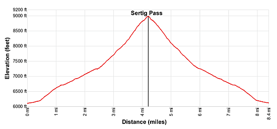
- Distance: 8.4 miles (round trip) to Sertig Pass
- Elevation: 6,099-ft. at Trailhead
8,986-ft. at Sertig Pass - Elevation Gain: 2,887-ft. to Sertig Pass
- Difficulty: moderate-strenuous
- More Hikes in:
Davos / Eastern Switzerland
Why Hike Sertig Pass
The beautiful Sertig Valley, a tributary of the Landwasser Valley, extends southeast through lush pastures with enticing views of the surrounding high peaks. Beyond the last village the valley splits into the Ducan and Chuealp valleys. This scenic hike ascends the Chuealp Valley (Chuealptal), clad in pretty meadows and rimmed by rugged peaks, to Sertig Pass.
From the pass views extend south to the cirque ringing the lovely Tschuvel Valley, anchored by photogenic Piz Kesch and the glistening Porchabella Glacier. The serrated peaks of the Ducan Range dominate the view to the west while the Bocktenhorn and neighboring summits soar above Chuealptal.
The broad pass is a great place for a picnic or simply to take a break to enjoy the views. Watch your time so you don’t miss the last bus of the day returning to Davos from Sertig Sand. Energetic hikers with the time and favorable weather will want to extend the hike by continuing over the pass to Durrboden. See the Sertig to Durrboden hike for more information.
I strongly recommend getting the first bus of the day to trailhead at Sertig Sand. This will allow plenty of time to enjoy this beautiful hike at your leisure.
Elevation Profile
| Support our Site |
Trail Resources
Trail Detail/Full Description / Trail Photo Gallery / Trail Map
Basecamp(s) Information:
Davos
Region Information:
Eastern Switzerland
Other Hiking Regions in:
Switzerland