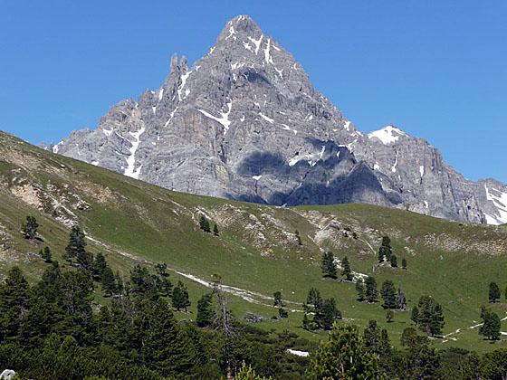
Close-up of Piz Plavna Dadaint
Panoramic views of rugged peaks, two beautiful valleys and a chance to see wildlife are the scenic rewards of this great hike, one of the best in the Swiss National Park, visiting Val Minger and Val Plavna.
See Trail Detail/Full Description
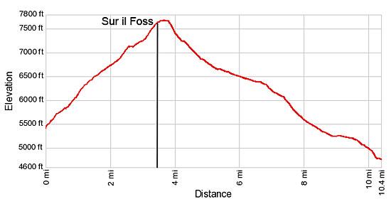
- Distance: 6.8 miles (round trip) to Sur il Foss
10.4 miles (one way) to Tarasp (Complete Hike) - Elevation: 5,428-ft. at Trailhead
7,664-ft. at Sur il Foss
4,616-ft. at Tarasp (Complete Hike) - Elevation Gain: 2,236-ft. to Sur il Foss
-3,408-ft. to Tarasp (Complete Hike) - Difficulty: moderate-strenuous
- More Hikes in:
Scuol / Eastern Switzerland
Why Hike Val Minger
This beautiful hike, my favorite in the Swiss National Park, ascends Val Minger to the beautiful meadows of Alp Minger with panoramic views of Piz Minger, Piz Foraz and Piz Plavna Dadaint. From the alp the trail climbs to Sur il Foss, a saddle on the ridge between Piz Minger and Piz Foraz, and then ascends along the scenic ridge. Magnificent, 360-degree views from the ridge encompass the peaks ringing the Plavna and Minger valleys along with the Sesvenna Lischana range to the east and the wall of peaks rising above the Lower Engadine Valley to the north.
From the ridge the trail drops down to the bucolic meadows of Alp Plavna and then descends along Val Plavna’s extensive flood plain, lined with rugged peaks. The final leg of the hike drops through meadows and forests to the village of Tarasp, with intermittent views of the high peaks rising above Ftan and Scuol.
Hikers looking for a more challenging day will want to continue the hike from Sur il Foss over Fuorcla Val dal Botsch to Il Fuorn. This leg of the hike is very strenuous and includes steep ascents and descents.
Elevation Profile
| Support our Site |
Trail Resources
Trail Detail/Full Description / Trail Photo Gallery / Trail Map
Basecamp(s) Information:
Scuol
Region Information:
Eastern Switzerland
Other Hiking Regions in:
Switzerland