Mattmark to Heidbodme via Jazzilucke 
Distance: 9.6 - 10.8 miles (one way)
near Saas Fee in The Valais
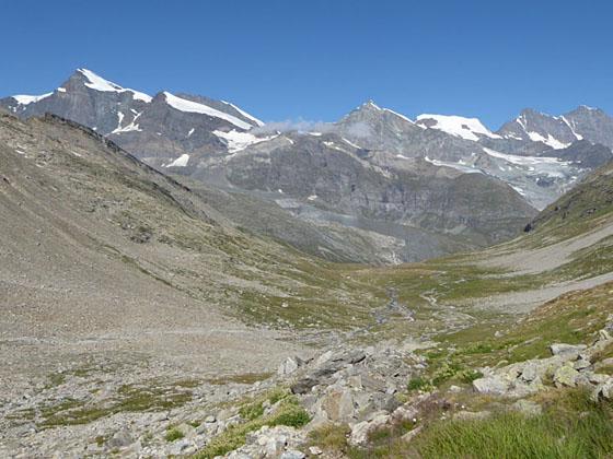
View down the Ofen valley on the climb to Jatzilucke
A great hike traversing two beautiful valleys connected by a challenging, exposed trail traveling between the Jazzilucke and Antrona passes on the Swiss-Italian border.
See Trail Detail/Full Description
- Distance: 4.8 miles (one way) to Jazzilucke
5.6 miles (one way) to Antrona Pass
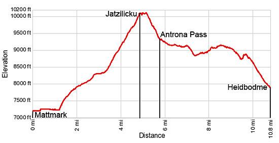
10.8 miles (one way) to Heidbodme - Elevation: 7,193-ft. at Trailhead
10,129-ft. at Jazzilucke
9,311-ft. at Antrona Pass
7,698-ft. at Heidbodme - Elevation Gain: 2,936-ft. to Jazzilucke
-818-ft. to Antrona Pass
-2,000-ft. to Heidbodme - Difficulty: strenuous-difficult
- More Hikes in:
Saas Fee / The Valais
Why Hike Mattmark to Heidbodme via Jazzilucke
This challenging hike ascends the beautiful Ofen Valley accompanied by panoramic views of the peaks surrounding the Mattmark Dam and beyond. At Jazzilucke, the high point of the hike, a narrow, exposed trail travels along ledges clinging to the sheer east face of the Jazzihorn before climbing rocky slopes to the peak’s eastern ridge.
The trail then descends along the ridge crest to Antrona Pass, located on the saddle between the Jazzihorn and Latelhorn. Antrona Pass, once an important medieval trade route, is a wild and remote spot with views extending down the Furgg Valley in Switzerland and southeast to the high peaks rimming the Troncone Valley in Italy.
Beyond the pass the trail follows an undulating high route traversing the Furggtal’s steep eastern slopes. This trail segment enjoys extended views of the 13,000-ft. (4,000-meter) peaks rising above Saas Fee. The trail ends at Heidbodme, a scenic overlook with panoramic views of the peaks towering above the Saastal (Saas Valley).
This trail is recommended for experienced hikers with a good head for heights. Sections of the trail between Jazzilucke to Antrona Pass are exposed. Don't hike this trail during bad weather or if the weather is taking a turn for the worse. The trail should also be avoided if covered by ice or slick snow.
I strongly recommend getting an early start for this hike. Warm air rising from the Troncone Valley in Italy often causes mist/clouds to form along the east face of the Jazzihorn and around Antrona pass by mid-day, enveloping the exposed section of the trail and obscuring views into Italy.
Although this trail can be hiked in either direction, I recommend starting at Mattmark and walking in a counter-clockwise direction to reach Jazzilucke and the traverse to Antrona Pass, the most challenging part of the hike, earlier in the day. (See the trailhead directions below.)
Before starting the hike, be sure to check the times for the last chairlifts down from Heidbodme and Furggstalden. It is a long and very steep walk down to Saas Almagell if you miss the last lift. An alternative and easier route, descending from Antrona along the floor of the Furgg Valley to Furggstalden, is a recommended alternative for hikers who are tired or pressed for time.
Elevation Profile
| Support our Site |

Trail Resources
Trail Detail/Full Description / Trail Photo Gallery / Trail Map
Basecamp(s) Information:
Saas Fee
Region Information:
The Valais
Other Hiking Regions in:
Switzerland