Backpack: Big Sandy to Elkhart Park via Fremont and Highline Trails
Side Trip: Bonneville Lakes
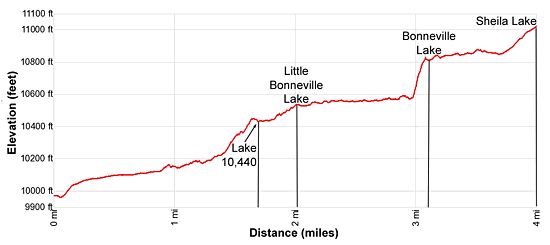
Distance: 4.0 miles
Bridger Wilderness, Bridger-Teton National Forest, near Big Sandy in Wyoming's Wind River Range
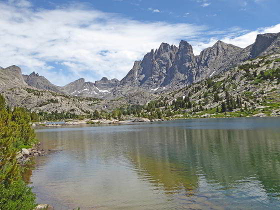
Little Bonneville Lake
- Distance: 4.0 miles
- Elevation: 9,980-ft at Junction Bonneville Lakes Trail
10,000-ft. at basin above Raid Lake
10,440-ft. at Lake 10,440
10,540-ft. at Little Bonneville Lake
10,828-ft. at Bonneville Lake
11,015-ft. at Sheila Lake - Difficulty: strenuous
- Basecamp: Big Sandy
- Region: Wyoming's Wind River Range
Bonneville Lakes Description
The stunningly beautiful Bonneville Lakes basin is composed of three lakes. Lake 10,521-ft. (aka Little Bonneville) is the lowest and prettiest of the three lakes with fine views of Mt. Bonneville (12,585-ft.) and good camping. The middle lake at 10,828-ft. (Bonneville Lake) resides in a stark bowl at the foot of Mt. Bonneville. The upper Bonneville, Sheila Lake (11,015-ft.), lies cradled in a rugged bowl beneath the cirque formed by Sentry Peak (11,925-ft.), North Lion (12,326-ft.), South Lion (12,305-ft.) and Mt. Bonneville.
The use trail to Bonneville Lakes is reasonably easy to follow up to Little Bonneville Lake. Beyond that point the trail is poorly marked and fades as it traverses boulder fields, travels through marshy meadows and climbs a very steep slope to Bonneville Lake (the middle lake). From the Bonneville Lake a route skirts the western shore, traveling through talus fields and then ascends rocky meadows to Sheila Lake. Always carry good maps, preferably topos, if you plan to travel on unmaintained trails or go off-trail.
This description assumes you are heading northbound on the Fremont Trail. If heading south, the unmarked junction with the trail to the Bonneville lakes is located in the meadow just before you cross Raid Lake’s inlet stream.
For northbound backpackers, the unmaintained trail to the Bonneville Lakes starts above the northeast arm of Raid Lake. Here the Fremont Trail crosses to the west side of Raid Lake’s inlet stream (the South Fork of Boulder Creek). A short distance beyond the crossing is an unmarked junction where the trail to the Bonneville Lakes basin branches right (northeast). The Fremont Trail curves to the west, skirting the north shore of a small pond to the west of the inlet stream.
Turn right (northeast) at the unmarked junction toward the Bonneville Lakes. The trail descends through meadows and crosses the South Fork (Raid’s inlet stream). You can typically rock-hop across the creek without getting your feet wet.
Beyond the crossing the path climbs through meadows scattered with willows and curves to the right (east). Soon the grade abates and the trail turns to the left (northeast), traversing through meadows with scattered trees growing amid rock outcroppings.
Reach a beautiful basin at 0.5 miles. Here fine views open to Mount Bonneville, the Twin Lions and Mt. Lander towering above the Bonneville basin to the northeast. Good campsites are located in the trees surrounding the meadows.
At the head of the basin the trail crosses to the north side of South Fork Creek, which feeds a shallow lake surrounded by marshy meadows to the northwest. The trail now curves to the right and ascends on easy grades through meadows choked with willows above the north side of the stream. Ahead the tip of Mount Bonneville is seen above the steep slopes of a low ridge.
At 1.1 miles the trail briefly enters the trees and then continues through willows, crossing a minor stream at 1.3 miles. Views opens to a small pond to the left (north) of the trail. At the southeast end of the pond is a junction at 1.4 miles. Bear right (east) at the junction. (This section of the trail can be confusing.) The last time I passed this spot, pieces of wood partially blocked the trail heading left (the wrong trail) along the east shore of the pond.
Follow the trail as it climbs through trees on moderately steep grades. As the trail ascends it curves to the right (southeast). At 1.7 miles the path drops down to the north shore of Lake 10,440. From this unnamed lakes enjoy nice views of Raid Peak rising to the east and the jagged spires of Mount Bonneville towering above the upper basin to the northeast. There are a few OK campsites in the wooded hills above the lake.
At the lake the trail turns left (northeast), briefly travels along the lakeshore and then ascends on easy grades through the flower-filled meadows to the north of the inlet stream. Soon the path starts climbing the north side of a gully channeling South Fork Creek between Lower Bonneville Lake and the unnamed lake. Short sections of the trail steeply ascend and then descend to circumvent obstacles.
At 1.9 miles the trail ascends through a small boulder field. Stay to the left (northwest) side of the stream as you climb through the rocks. Beyond the boulders the path is easier to follow.
Reach the southwest end of the Little Bonneville Lake (10,540-ft.) at 2.0 miles. This lake, in my opinion, is the prettiest of the three lakes with terrific views of Mount Bonneville. Good campsites can be found in the trees around the lakeshore. Please be sure to camp 200-ft. from the lake.
The trail now heads north, traversing the west side of Little Bonneville Lake. At the head of the lake the trail curves to the right (east) and travels through a boulder field and then meadows along the base of Peak 11,865. The trail fades and is difficult to follow as it travels through the meadows above two small ponds. Ahead views open to a waterfall spilling down the steep slopes separating the lower and middle lakes.
Beyond the last pond continue through the meadows along the north side of the lower lake basin. As you approach the head of the lower basin, look for a trail climbing the meadows to the right (east) of the waterfall spilling down the headwall. This is the trail to the middle lake.
A faint trail leads to a crossing of the South Fork near the base of the falls. The crossing is located amid thick willows. If you lose the trail, find a good place to carefully cross the stream and then locate the trail in the meadows on the east side of the creek/falls.
The route now climbs on very steep grades up the hillside, skirting the left side of a cluster of stunted conifers. Past the last of the trees the trail swings to the right (southeast) and then the left (east/northeast) and starts an extremely steep climb up a rocky chute. You may need to use your hands for balance. As you climb, keep looking left for a shelf where you will exit the chute. The exit from the chute, marked with a small cairn, is easily missed if you are concentrating on climbing.
At the shelf, turn left (west/northwest) to exit the chute. The path now ascends on more reasonable grades along the shelf towards the falls. As you near the falls the trail curves to the right (northeast) and finally crests the headwall, reaching the stark basin cradling Bonneville Lake (10,828-ft.) at 3.2 miles. Mt Bonneville looms above the eastern side of the lake. Peak 11,865 and Sentry Peak rim the basin to the north. The tip of Nylon Peak, South Twin Lion and Mt. Lander are seen rising up the upper basin to the northeast.
To reach Sheila Lake, the upper Bonneville Lake, cross the outlet stream for Bonneville Lake and then travel through rocky meadows and talus slopes along the western and then northern lakeshores. At the head of the lake cross to the east side of the lake’s inlet stream. Ascend the rocky meadows to the east/southeast of the stream to the shore of Sheila Lake (11,015-ft.) at 4.0 miles. Sheila Lake (11,015-ft.) lies nestled in a rugged bowl beneath the cirque formed by Sentry Peak (11,925-ft.), North Lion (12,326-ft.), South Lion (12,305-ft.) and Mt. Bonneville.
Find a scenic perch along the lakeshore to take in the views. When you are done enjoying the lake basin, retrace your steps to your campsite.
Note: There are two passes that link the Bonneville Lakes basins to Lee Lake and Middle Fork Lake to the north. The lower pass between Peak 11,865 and Sentry Peaks, sometimes referred to as Sentry Pass, is accessible from Bonneville Lake and requires climbing up a series of ledges to circumvent cliffs and loose talus. On the north side of the pass is more talus. The higher pass, between Sentry Peak and North Lion, is reached via steep, loose talus slopes above Sheila Lake. These passes are recommended only for backpackers with good route finding skill and experience crossing rugged, off-trail terrain.
Return to Segment 2: Marms Lake to Raid Lake
Go To Segment 3: Raid Lake to Middle Fork Junction above Sandpoint Lake
Elevation Profile
Backpack Segments
- Introduction: Big Sandy to Elkhart Park via Fremont and Highline Trails
- Segment 1: Big Sandy to Marms Lake
- Segment 2: Marms Lake to Raid Lake
- --- Side Trip: Bonneville Lakes
- Segment 3: Raid Lake to Middle Fork Junction above Sandpoint Lake
- --- Side Trip: Middle Fork Lake Trail
- --- Side Trip: Middle Fork Lake via the Rainbow Lake Trail
- --- Side Trip: Photo Pass Trail
- Segment 4: Sandpoint Lake to Valley Lake Junction
- --- Side Trip: Europe Canyon and Pass
- Segment 5: Valley Lake Junction to North Fork Lake
- --- Side Trip: Hay Pass, the Golden Lakes and Fall Creek Pass
- Segment 6: North Fork Lake to Bell Lakes Junction
- Segment 7: Bell Lakes Junction to Pole Creek
- --- Side Trip: Cook and Wall Lakes
- Segment 8: Pole Creek to Little Seneca Lake
- Segment 9: Little Seneca Lake to Island Lake
- --- Side Trip: Titcomb Basin
- --- Side Trip: Indian Basin and Pass
- --- Side Trip: Island Lake Waterfall Hike
- Segment 10: Island Lake to Elkhart Park
Driving Directions to Big Sandy Trailhead
Big Sandy Trailhead: This popular trailhead is located in the southern Wind River Range next to the Big Sandy River.
Directions from Pinedale: From the intersection of Pine Street (US 191) and North Tyler Ave (the Pinedale Tourism office is located on the northeast corner) in Pinedale, WY, drive south on Highway 191 for 11.7 miles and then turn left (east) on WY-353. After 15.5 miles you will notice signs referring to the road as the Big Sandy-Elkhorn Road and after 18 miles the paved road will change to a good packed dirt/gravel surface.
Shortly after the pavement ends go straight through a junction, and drive south crossing the Big Sandy River (Buckskin Crossing). Follow the road for a total of 27.3 miles. Shortly after crossing the Big Sandy River you will reach a junction with the Lander Cutoff Road (the next junction). Turn left on the Lander Cutoff Road. There is a wood sign at the intersection pointing toward the Big Sandy trailhead.
Drive 7.0 miles on the Lander Cutoff Road and then turn left on the Big Sandy Opening Road. Here you will see a sign for the Big Sandy Campground and trailhead. The road now deteriorates and narrows. Blind corners and lush foliage along the road make it hard to see ahead. Drive carefully, following the rocky, rutted road for 9.8 miles to a "Y" intersection. Bear right at the intersection to continue along the Big Sandy Opening Road (Forest Service Road 850). (The road branching to the left leads to the Big Sandy Lodge and Mud Lake.) Follow the road for 0.8 miles to the trailhead parking area, equipped with an outhouse.
Allow an hour and a half to reach the trailhead from Pinedale. The parking area is too small for the number of backpackers visiting the area during the height of the summer. If the parking area is full, find a safe place to park off the access road.
I recommend a high clearance vehicle to reach the trailhead. Passenger cars can make it OK if driven carefully. Check at the Pinedale ranger station before starting your trip to learn about current road and trail conditions. The Ranger Station is located to the east of the Ridleys Grocery Store on US 191 (Pine Street in Pinedale). The entrance to the ranger station is on the Fremont Lake Road. (You can also reach the parking area for the ranger station by driving east through the Ridley’s parking lot.)
This trailhead is remote, so be sure to have a full tank of gas. The dirt road become slippery when wet. The campground at the parking area is tiny, with only 4 sites. I would not plan on camping at the trailhead before starting your backpack.
Elkhart Park Trailhead: From the intersection of Pine Street (US 191) and North Tyler Ave (the Pinedale Tourism office is located on the northeast corner) in Pinedale, WY, drive east on Highway 191 (East Pine Street) for 0.3 miles and bear left onto Fremont Lake Road. Follow this road for 14.3 miles and turn right into the large parking area for the Elkhart Park/Pole Creek Trailhead. After the first 3.0 miles the road will turn into Skyline Drive/Forest Service Road 370740. The trailhead is located at the northeast end of the parking lot between the outhouse and the trailhead kiosk. It should take about 25 minutes to drive the trailhead. The last section of the road has some holes and uneven spots.
Trail Resources
- Backpack Intro
- Segment Photo Gallery
- Segment Map
- Trailhead(s) Information: Big Sandy
- Region Information: Wyoming's Wind River Range
- Other Hiking Regions in: Wyoming