Backpack: Big Sandy to Elkhart Park via Fremont and Highline Trails
Segment 8: Pole Creek to Little Seneca Lake
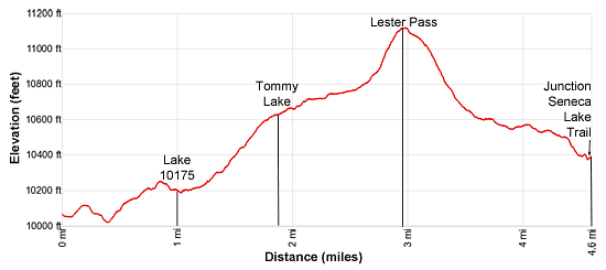
Distance: 4.6 miles (one way)
Bridger Wilderness, Bridger-Teton National Forest, near Big Sandy in Wyoming's Wind River Range
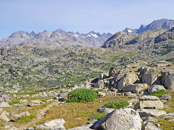
Looking north from Lester Pass
- Distance: 4.6 miles
- Elevation: 10,065 at Junction with Highline Trail
10,175-ft. at Lake 10175
10,565-ft. at Tommy Lake
11,060-ft. at Lester Pass
10,400-ft. at Junction Seneca Lake and Highline Trails - Difficulty: strenuous
- Basecamp: Big Sandy / Elkhart Park
- Region: Wyoming's Wind River Range
Pole Creek to Little Seneca Lake Description
This trail segment starts near Pole Creek at the junction of the Highline and Fremont Trails. The junction marks the northern end of the Fremont Trail. Here the southbound Highline trail branches left (west) and descends along the left (south/southeast side) of Pole Creek toward the Pole Creek Lakes and the Pole Creek Trail. Straight ahead (northwest) the northbound Highline leads to Lester Pass and Little Seneca Lake. Behind you the southbound Fremont Trail ascends southeast toward Bald Mountain Basin and Hat Pass.
We head northwest on the northbound Highline toward Lester Pass. Almost immediately the trail arrives at a knee-deep ford of Pole Creek. After crossing the creek the path climbs over a small rises and then rock-hops across a tributary of Pole Creek to reach a four-way junction at 0.4 miles. Here a second trail turns right (northeast) toward the Cook Lakes. To the left is a spur trail leading to a lower crossing of Pole Creek that connects to the southbound Highline. We continue straight ahead on the Highline trail toward Lester Pass.
Beyond the junction the trail ascends a narrow draw on moderate grades and then weaves around and over rock outcroppings, passing a few small ponds. At 1.0 miles the path reaches the southern end of Lake 10175. Mount Lester (12,342-ft.) and Peak 11740 rise to the north whiles the peaks rimming the Continental Divide fill the skyline to the east.
The lake is surrounded by timbered knobs and offers limited camping. A few small sites are located along the east side of the outlet stream and atop the knoll to the west of the trail before you cross the outlet stream. Better camping is found around Tommy Lake further up the trail.
Follow the trail as it swings around the west side of the lake and soon crosses the outlet stream. Beyond the crossing an undulating traverse along the western shore leads to the head of the lake. Here the trail starts climbing on moderate grades through forest, gradually curving to the left (northwest). As you ascend the trees give way to pretty meadows.
At 1.8 miles the grade abates and views open to Tommy Lake (10,565-ft.). Mount Lester and Peak 11740 tower above the lake basin to the north. The path now ascends on easy grades through alpine meadows above the west side of the lake. Nice campsites are located in the trees and rock outcroppings surrounding the lake.
Past the head of the lake the trail climbs on moderate grades through rocky meadows, crossing the inlet stream for Tommy Lake. Turn around for nice views of Angel Peak (12,402-ft.) and Angel Pass to the southeast. To the west, hidden by rocky knolls, is Lake Nelson.
The grade eases as the trail travels through a basin at the head of the valley littered with rock outcroppings and small ponds. Soon the path curves to the right (north) and starts ascending on moderate grades up the valley’s headwall. As you climb turnaround for more good views to the southeast. To the south views open to Nelson Lake set amid rocky knobs and alpine meadows.
At 2.7 miles the trail swings to the left (northwest), climbing steep switchbacks up talus slopes to Lester Pass (11,060-ft.) at 2.9 miles. The pass, a broad saddle clad in alpine meadows, sits atop the ridge extending southwest from Mt. Lester. As you cross to the south side of the saddle a breathtaking scene springs into view. To the north a sea of jagged peaks towering above Titcomb Basin, Island Lake and the Fremont Valley fills the skyline. Snowcapped Gannett Peak (13,804-ft.) rises beyond Mt. Woodrow Wilson (13,502-ft.) at the head of Titcomb Basin. Fremont Peak (13,745-ft.), Mt. Sacagawea (13,569-ft.) and Mt Helen (13,620-ft.) extend north along the Continental Divide, forming the basin’s eastern wall. Other prominent peaks include Henderson Peak (13,115-ft.), Bow Mountain (13,020-ft.) and Mt. Whitecap (13,020-ft.).
Drop down the south side of the pass for a short distance for the best views. A camera with a zoom lens or binoculars will help you pick out the individual peaks on the skyline.
When you are done taking in the views drop down the south side of the pass on moderate grades through rocky meadows. At 3.1 miles the trail starts descending steep switchbacks. Below views open to a beautiful lake basin.
At 3.5 miles the grade eases as the trail enters the lakes basin and soon crosses a small stream. The trail now follows an undulating course through a landscape of granite domes, outcroppings and boulders. Small meadows and thickets of willows grow amid the rocks.
At 3.9 miles the trail traverses a rocky spine between two lakes. At the foot of the lakes the trail curves to the left (northwest), crosses the outlet stream of the larger of the two lakes and then descends on moderate grades along the west side of a draw.
At the base of the draw is an unnamed lake. The trail now drops steeply down to the lake’s western shore and crosses the outlet stream at 4.5 miles. A short climb up the hill to the east of the outlet leads to a junction with the Highline/Continental Divide and Seneca Lake trails at 4.6 miles. (Note the sign only lists the Continental Divide Trail.) Turn right (northeast) at the junction on the combined Highline/Continental Divide Trails to reach Island Lake or Fremont Crossing. The Seneca Trail, branching west, travels around the head of Little Seneca Lake and then turns southwest toward Seneca Lake. This trail ultimately connects with the Pole Creek trail to the Elkhart Park trailhead.
Return to Segment 7: Bell Lakes Junction to Pole Creek
Go To Segment 9: Little Seneca Lake to Island Lake
Elevation Profile
Backpack Segments
- Introduction: Big Sandy to Elkhart Park via Fremont and Highline Trails
- Segment 1: Big Sandy to Marms Lake
- Segment 2: Marms Lake to Raid Lake
- --- Side Trip: Bonneville Lakes
- Segment 3: Raid Lake to Middle Fork Junction above Sandpoint Lake
- --- Side Trip: Middle Fork Lake Trail
- --- Side Trip: Middle Fork Lake via the Rainbow Lake Trail
- --- Side Trip: Photo Pass Trail
- Segment 4: Sandpoint Lake to Valley Lake Junction
- --- Side Trip: Europe Canyon and Pass
- Segment 5: Valley Lake Junction to North Fork Lake
- --- Side Trip: Hay Pass, the Golden Lakes and Fall Creek Pass
- Segment 6: North Fork Lake to Bell Lakes Junction
- Segment 7: Bell Lakes Junction to Pole Creek
- --- Side Trip: Cook and Wall Lakes
- Segment 8: Pole Creek to Little Seneca Lake
- Segment 9: Little Seneca Lake to Island Lake
- --- Side Trip: Titcomb Basin
- --- Side Trip: Indian Basin and Pass
- --- Side Trip: Island Lake Waterfall Hike
- Segment 10: Island Lake to Elkhart Park
Driving Directions to Big Sandy Trailhead
Big Sandy Trailhead: This popular trailhead is located in the southern Wind River Range next to the Big Sandy River.
Directions from Pinedale: From the intersection of Pine Street (US 191) and North Tyler Ave (the Pinedale Tourism office is located on the northeast corner) in Pinedale, WY, drive south on Highway 191 for 11.7 miles and then turn left (east) on WY-353. After 15.5 miles you will notice signs referring to the road as the Big Sandy-Elkhorn Road and after 18 miles the paved road will change to a good packed dirt/gravel surface.
Shortly after the pavement ends go straight through a junction, and drive south crossing the Big Sandy River (Buckskin Crossing). Follow the road for a total of 27.3 miles. Shortly after crossing the Big Sandy River you will reach a junction with the Lander Cutoff Road (the next junction). Turn left on the Lander Cutoff Road. There is a wood sign at the intersection pointing toward the Big Sandy trailhead.
Drive 7.0 miles on the Lander Cutoff Road and then turn left on the Big Sandy Opening Road. Here you will see a sign for the Big Sandy Campground and trailhead. The road now deteriorates and narrows. Blind corners and lush foliage along the road make it hard to see ahead. Drive carefully, following the rocky, rutted road for 9.8 miles to a "Y" intersection. Bear right at the intersection to continue along the Big Sandy Opening Road (Forest Service Road 850). (The road branching to the left leads to the Big Sandy Lodge and Mud Lake.) Follow the road for 0.8 miles to the trailhead parking area, equipped with an outhouse.
Allow an hour and a half to reach the trailhead from Pinedale. The parking area is too small for the number of backpackers visiting the area during the height of the summer. If the parking area is full, find a safe place to park off the access road.
I recommend a high clearance vehicle to reach the trailhead. Passenger cars can make it OK if driven carefully. Check at the Pinedale ranger station before starting your trip to learn about current road and trail conditions. The Ranger Station is located to the east of the Ridleys Grocery Store on US 191 (Pine Street in Pinedale). The entrance to the ranger station is on the Fremont Lake Road. (You can also reach the parking area for the ranger station by driving east through the Ridley’s parking lot.)
This trailhead is remote, so be sure to have a full tank of gas. The dirt road become slippery when wet. The campground at the parking area is tiny, with only 4 sites. I would not plan on camping at the trailhead before starting your backpack.
Elkhart Park Trailhead: From the intersection of Pine Street (US 191) and North Tyler Ave (the Pinedale Tourism office is located on the northeast corner) in Pinedale, WY, drive east on Highway 191 (East Pine Street) for 0.3 miles and bear left onto Fremont Lake Road. Follow this road for 14.3 miles and turn right into the large parking area for the Elkhart Park/Pole Creek Trailhead. After the first 3.0 miles the road will turn into Skyline Drive/Forest Service Road 370740. The trailhead is located at the northeast end of the parking lot between the outhouse and the trailhead kiosk. It should take about 25 minutes to drive the trailhead. The last section of the road has some holes and uneven spots.
Trail Resources
- Backpack Intro
- Segment Photo Gallery
- Segment Map
- Trailhead(s) Information: Big Sandy / Elkhart Park
- Region Information: Wyoming's Wind River Range
- Other Hiking Regions in: Wyoming