Backpack: Big Sandy to Elkhart Park via Fremont and Highline Trails
Side Trip: Hay Pass, the Golden Lakes and Fall Creek Pass
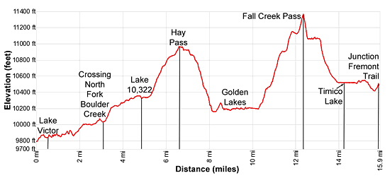
Distance: 6.6 - 15.9 miles (one way)
Bridger and Fitzpatrick Wilderness es, Bridger-Teton and Shoshone National Forests, near Big Sandy in Wyoming's Wind River Range
Dennis Lake, Angel Pass and Angel Peak from Hay Pass
- Distance: 6.6 - 15.9 miles
- Elevation: 9,785-ft. at Junction Hay Pass/Highline Trail
9,834-ft. at Lake Victor
10,960-ft. at Hay Pass
10,155-ft. at Golden Lake
10,176-ft. at Upper Golden Lake
11,370-ft. at Fall Creek Pass
10,512-ft. at Timico Lake
10,470-ft. at Junction Fremont/Bell Lakes Trails - Difficulty: strenuous
- Basecamp: Elkhart Park / Big Sandy
- Region: Wyoming's Wind River Range
Hay Pass, the Golden Lakes and Fall Creek Pass Description
The Hay Pass Trail, an excellent side trip off the Fremont Trail, traverses the western shores of Lake Victor and then ascends the beautiful North Fork Canyon to scenic Hay Pass on the Continental Divide. From the pass enjoy fine views of Dennis Lake and the high peaks towering above the Middle Fork Bull Creek Valley to the north. Due to its length, the day hike to the pass is best done from a basecamp at Lake Victor or along the North Fork Canyon.
The trip can be extended into an interesting loop that descends an old, unmaintained trail from Hay Pass to the Golden Lakes. From the Golden Lakes an off-trail route climbs to Fall Creek Pass on the Continental Divide and then descends past Timico Lake to the Fremont Trail at the Bell Lakes junction. From the junction, follow the Fremont Trail back to your starting point or head north along the Fremont toward Bald Mountain Basin and Lester Pass. The trip to the Golden Lakes and Fall Creek Pass are only recommended for parties experienced with off-trail navigation and route finding.
The Hay Pass trail is located along the Fremont Trail just above the northwest corner of North Fork Lake. Here there is a four-way junction with the trail to Hay Pass branching north. The Highline trail to the southwest heads Lake Vera. The Fremont trail to the northwest ascends to August Lake and Hat Pass while the Fremont trail to the southeast leads to the Pipestone Lakes.
Backpackers heading north/northwest on the Fremont trail wishing to visit Lake Victor and Hay Pass should turn right (north) at the junction on the Hay Pass Trail. The path climbs on easy grades up a narrow draw to a bench where the grade abates. At 0.4 miles views open to a small pond just to the south of Lake Victor.
Reach the foot of beautiful Lake Victor (9,834-ft.) at 0.7 miles. Mount Victor (12,254-ft.) towers above the head of the lake dotted with small islands. Numerous peninsulas jutting into the lake create small bays along the lakeshore. Scenic campsites are located amid the trees and rock outcroppings along the lakeshore. Several large campsites near the lower end of the lake are frequented by wilderness pack outfitters and fishing groups. Don’t expect solitude if you choose to camp in this area.
The undulating trail along the west side of the lake wanders through meadows strewn with rock slabs and winds between outcroppings scattered with trees. After an initial stint along the lakeshore the trail moves away from the shoreline to follow a more direct path to the northeast that avoids the lake’s bays.
At 1.2 miles the trail passes to the west of a small pond and then climbs over two tree clad knolls, reaching the head of the lake at 1.7 miles. Here the trail drops down to and crosses the North Fork of Boulder Creek. Depending on the water level you may need to wade across the creek.
After crossing the creek the trail turns left (northwest) and travels up the east side of the North Fork Canyon, ascending through meadows and scattered trees. As you climb views open to Round Top Mountain (12,048-ft.) and a ridge of 11,000-ft. peaks rimming the west side of the canyon.
At 2.2 miles Lake 9,981, set amid emerald green meadows, comes into view. Scenic, secluded campsites are located amid the trees and the rock outcroppings to the south of this pretty lake.
Follow the trial as it skirts the east side of Lake 9,981 and then climbs over a knoll as it proceeds up the canyon. At 3.1 miles the trail begins a moderate climb through spruce-pine forest. Openings in the trees offer good views of the surrounding peaks.
At 4.0 miles the trail curves to the right (north) as it breaks from the trees, ascending on easy to moderate grades through meadows scattered with willow-thickets and conifers. Round Top Mountain dominates the view to the northwest.
As you near Lake 10,322, the trail swings to the left (northwest), climbs a knoll and then drops down to the lake’s outlet stream at 4.8 miles. Rock-hop across the outlet stream and then traverse the lake’s western shore. Campsites are located above the south and eastern shores.
As you proceed along the lake views open to southeast trending valley to the east of Lake 10,322. This pretty, isolated valley behind Mt. Victor harbors Glacier Lake, worth a side trip if time and energy permit. (Information about the route up Glacier Valley is at the end of this trail description.)
Beyond the head of the lake the trail climbs on moderate to moderately-steep grades through rocky meadows toward Hay Pass. As you ascend enjoy fine views of Mt. Victor rising above the southeast trending side valley. Behind you the peaks towering above the west side of North Fork Canyon fill the skyline.
At 5.75 miles the grade abates briefly as the trail passes to the east of scenic Beth Lake (10,755-ft.). Round Top Mountain dominates the view to the west of the lake while Mt. Victor rises to the southeast. Ahead the valley is rimmed by unnamed peaks.
Past the lake the climb resumes on moderate grades through rocky meadows along the east side of the valley. Turn around for ever-improving views of the peaks rimming the North Fork Canyon.
Reach Hay Pass (10,960-ft.) at 6.6 miles. The pass is located atop a broad ridge on the Continental Divide. To the south the summits and lakes of the North Fork of Boulder Canyon dominate the view.
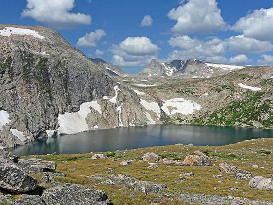
For the best views to the north, follow the boot beaten path crossing the ridge for 0.2 miles. As you proceed fine views open to Mount Quintet (11,922-ft.), Douglas Peak (12,192-ft.) and neighboring unnamed peaks towering above the Middle Fork Bull Lake Valley to the north/northeast. Soon Dennis Lake (10,630-ft.), cradled in a deep bowl, springs into view. Steep cliffs rise above the lake’s southwest shore. Angel Peak (12,402-ft.) rises in the distance to the west.
Ahead the trail drops down the slopes along the lake’s eastern shore, bound for the Golden Lakes. If Hay Pass is your destination, I recommend leaving the trail and continuing north along the ridge crest above the lake’s eastern shore. To the west views expand to include the distinctively shaped Angel Pass, the “U” shaped saddle to the south of Angel Peak. To the northwest, Birch Peak (12,314-ft.), Douglas Peak and Mount Quintet tower above the Golden Lakes.
For day hikers, this is a good turn around point. When you are done taking in the views, retrace your steps to your campsite.
Experienced backpackers travel along a variety of routes beyond Hay Pass to reach the Golden Lakes, Fall Creek and Angel Pass. Good maps and advanced planning are required to stay on route. Boot-beaten trails on the ground fade and disappear, requiring good navigational skills. Note: The Golden Lakes are frequented by bears. Use appropriate precautions if you drop down to the lakes to camp and explore.
To the Golden Lakes
An old trail, no longer maintained, descends from Hay Pass to the Golden Lakes. In the meadows beyond the pass to the east of Dennis Lake the trail fades and can be hard to follow. Obtain a Fremont Peak South topo map or print the map from the USGS.gov site. The topo shows the trail and will help you stay on track.
From the pass follow the boot beaten path north. After about a quarter mile the path starts descending on moderate grades through meadows along the slopes above the east side of Dennis Lake. To the west views expand to include the distinctively shaped Angel Pass, the “U” shaped saddle to the south of Angel Peak. To the northwest, Birch Peak (12,314-ft.), Douglas Peak and Mount Quintet tower above the Golden Lakes.
As you descend the grade steepens and the trail swings away from the lake, heading northeast as it switchbacks steeply down the hillside to a creek at 1.1 miles. Just before reaching the creek the trail turns left (northwest) and briefly descends along the west side of the creek. Soon the creek curves to the north while the trail continues dropping steeply to the northwest, reaching the outlet stream for Dennis Lake at the south end of Golden Lake (10,155-ft.) at 1.5 miles. Rocky knolls scattered trees and willow-choked meadows rim the shoreline.
Cross the outlet stream and travels around an arm extending west from the lake. Beyond the arm the route climbs over a knoll to the south end of Lake Louise (10,163-ft.) at 1.9 miles. Skirt the west shore of the lake and then travel through trees and meadows along the west side of the stream linking Lake Louise with Upper Golden Lake. Nice campsites are located in the trees between the two lakes.
Reach the south end of Upper Golden Lake (10,176-ft.) at 2.6 miles. Follow the trail as it curves around the south end of the lake to an inlet stream. The route to Fall Creek Pass ascends the east side of this stream. Cross the stream and then traverse the lake’s western shore to the head of the lake at 3.2 miles. Beyond Upper Golden Lakes route climb to Lake 10,787 and beyond.
The Golden Lakes are in bear country. When camping around the lakes follow proper precautions to keep your food out of the reach of bears.
Golden Lakes to Fall Creek Pass
Note: There is no trail to Fall Creek Pass. This is a route that requires navigational skill and a map. I only recommend this route for experienced backpacks that are comfortable with off-trail route finding. Always exercise caution and don’t take chances when venturing off-trail. Don’t attempt this route if the weather is bad or looks threatening. Most of this route is well above tree line and there is no place to take cover in the event of a storm.
To reach Fall Creek Pass, hike to the inlet stream at the southwest corner of Upper Golden Lake. Ascend south/southwest along the east side of the creek, climbing on moderate to moderately steep grade through trees and then meadows scattered with willow thickets.
After walking a little over a mile the grade abates as you will reach a bench. Here views open to Lake 10,885. Head southwest through alpine meadows on a route that skirts the southeast end of the lake. As you traverse the bench, enjoy great views of Angel Pass and Angel Peak to the west.
Reach the south end of the lake at 1.25 miles. Now head south, ascending toward Lake 11,125. Arrive at the southeast end of Lake 11,125 at 1.75 miles. Cross the outlet stream and then head southwest, ascending rocky meadows to Fall Creek Pass (11,370-ft.), the saddle on the ridge above the southeast end of the lake, at 2.1 miles.
Below, to the south, views open to Lake 11,045. Peak 12,236 rises to the west of Lake 11,045. Turn around for fine view of the lake basin you just traversed to the north of the pass.
Note: Please don’t be tempted to cross Angel Pass. The west side of the pass requires scrambling down class 2+ ledges. This route is for experienced scramblers, adepts at dropping down rock ledges while wearing a full backpack. Fall Creek is a much easier pass to cross.
Fall Creek Pass to Timico Lake and the Fremont Trail
Descend steeply through meadows to the head of Lake 11,045. Turn left (southeast) and travel around the east side of the lake to its outlet stream, Fall Creek, at 0.8 miles. Beyond the foot of the lake descend along the east side of Fall Creek. Soon the creek drops very steeply down a rocky slope. Use care as you descend. Beyond the initial drop, the route continues dropping steeply through rocky meadows. Along the way you will soon start seeing vestiges of a use-trail.
Soon the grade moderates. The route now descends through meadows sprinkled with wildflowers beside pretty Fall Creek. Ahead Timico Lake (10,512-ft.), sprawls across the valley floor. To the west the valley is rimmed by 11,000-ft. peaks. Round Top Mountain (12,048-ft.) towers above the east side of the valley.
Reach the head of Timico Lake at 1.7 miles. Turn left (southeast) and follow an undulating use trail around the east/southeast side of the lake to the outlet stream near the foot of the lake at 2.5 miles. As you travel around the lakeshore you will start following a boot beaten path that turns into a trail near the foot of the lake. The lake offers good fishing. Secluded, albeit exposed, campsites are located around the outlet stream.
Cross the outlet stream and then climb over a low knoll. Beyond the knoll the trail heads southwest, descending a meadow-clad draw on easy grades. Reach a small creek flowing out of a pond to the northwest of the trail at 3.3 miles. Cross the stream and follow the trail as it ascends through meadows on easy grades. As you climb the trail fades. Just continue heading east/southeast. Soon you will reach the Fremont Trail and a signed trail junction at 3.5 miles.
Here the northbound Fremont Trail to the right (north/northwest) leads the Cook Lakes. To the left is the southbound Fremont trail heads toward Hat Pass. To the southwest, essentially straight ahead, is the Bell Lakes trail that descends to a junction with the Baldy Lakes Trail and then to the Chain Lakes, located along the Highline Trail.
Glacier Lake Trail
A detour off the Hay Pass trail travels up a scenic, secluded valley to Glacier Lake nestled in alpine meadows beneath the north ridge of Mt. Victor.
There is no trail to Glacier Lake but the way is clear. To visit the lake, follow the Hay Pass trail for 4.7 miles to the south end of Lake 10,322. As you near the lake the Hay Pass trail swings to the left as it climbs a knoll. Instead of following the trail to the left, turn right (east) off the Hay Pass trail and ascend the slope above the southeast end of the lake on moderate grades, keeping to the south of the stream draining Glacier Lake Valley.
After climbing for about 0.6 miles you will reach a lake basin atop a bench. Here views open to ponds along the stream running down the valley floor. Mount Victor (12,254-ft.) and Europe Peak (12,259-ft.) tower above the head of the valley. In the distance, Horseshoe Ridge rises beyond the ridge at the head of the valley.
Head southeast up the south side of the valley, keeping to the grassy slopes well above the valley floor. The alpine meadows along the valley floor are quite boggy as a result of snowmelt trickling down the ridge above the route.
Along the way enjoy an amazing display of wildflowers in the well-water meadows. Unfortunately the wet meadows also produce a large number of mosquitos and flies. Be sure you have insect repellent!
Reach the western end of Glacier Lake (10,555-ft.) after walking about 1.2 miles. The area around the lakeshore is quite marshy. Low knolls along the shore offer dry perches to take in the views. Alternatively, cross to the north side of the outlet stream to find some drier ground.
To reach the saddle at the head of the valley, traverse the lakeshore to the head of the lake and then ascend the rocky meadows beyond the lake to the saddle. Total distance is about 2.6 miles. Here views open to beautiful Long Lake, resting in a long, narrow cleft between Mount Victor to the south and Europe Peak to the north.
During period of low water it is possible to drop down to navigate a course along the northeast shore of Long Lake. Otherwise the route is quite difficult and requires climbing high above the lake.
I personally recommend visiting Hay Pass and then taking a detour to explore the Glacier Lake Valley on the return trip down the North Fork Canyon.
Note: The western shore of Long Lake is accessible from Europe Canyon.
Return to Segment 5: Valley Lake Junction to North Fork Lake
Go To Segment 6: North Fork Lake to Bell Lakes Junction
Elevation Profile
Backpack Segments
- Introduction: Big Sandy to Elkhart Park via Fremont and Highline Trails
- Segment 1: Big Sandy to Marms Lake
- Segment 2: Marms Lake to Raid Lake
- --- Side Trip: Bonneville Lakes
- Segment 3: Raid Lake to Middle Fork Junction above Sandpoint Lake
- --- Side Trip: Middle Fork Lake Trail
- --- Side Trip: Middle Fork Lake via the Rainbow Lake Trail
- --- Side Trip: Photo Pass Trail
- Segment 4: Sandpoint Lake to Valley Lake Junction
- --- Side Trip: Europe Canyon and Pass
- Segment 5: Valley Lake Junction to North Fork Lake
- --- Side Trip: Hay Pass, the Golden Lakes and Fall Creek Pass
- Segment 6: North Fork Lake to Bell Lakes Junction
- Segment 7: Bell Lakes Junction to Pole Creek
- --- Side Trip: Cook and Wall Lakes
- Segment 8: Pole Creek to Little Seneca Lake
- Segment 9: Little Seneca Lake to Island Lake
- --- Side Trip: Titcomb Basin
- --- Side Trip: Indian Basin and Pass
- --- Side Trip: Island Lake Waterfall Hike
- Segment 10: Island Lake to Elkhart Park
Driving Directions to Elkhart Park Trailhead
Big Sandy Trailhead: This popular trailhead is located in the southern Wind River Range next to the Big Sandy River.
Directions from Pinedale: From the intersection of Pine Street (US 191) and North Tyler Ave (the Pinedale Tourism office is located on the northeast corner) in Pinedale, WY, drive south on Highway 191 for 11.7 miles and then turn left (east) on WY-353. After 15.5 miles you will notice signs referring to the road as the Big Sandy-Elkhorn Road and after 18 miles the paved road will change to a good packed dirt/gravel surface.
Shortly after the pavement ends go straight through a junction, and drive south crossing the Big Sandy River (Buckskin Crossing). Follow the road for a total of 27.3 miles. Shortly after crossing the Big Sandy River you will reach a junction with the Lander Cutoff Road (the next junction). Turn left on the Lander Cutoff Road. There is a wood sign at the intersection pointing toward the Big Sandy trailhead.
Drive 7.0 miles on the Lander Cutoff Road and then turn left on the Big Sandy Opening Road. Here you will see a sign for the Big Sandy Campground and trailhead. The road now deteriorates and narrows. Blind corners and lush foliage along the road make it hard to see ahead. Drive carefully, following the rocky, rutted road for 9.8 miles to a "Y" intersection. Bear right at the intersection to continue along the Big Sandy Opening Road (Forest Service Road 850). (The road branching to the left leads to the Big Sandy Lodge and Mud Lake.) Follow the road for 0.8 miles to the trailhead parking area, equipped with an outhouse.
Allow an hour and a half to reach the trailhead from Pinedale. The parking area is too small for the number of backpackers visiting the area during the height of the summer. If the parking area is full, find a safe place to park off the access road.
I recommend a high clearance vehicle to reach the trailhead. Passenger cars can make it OK if driven carefully. Check at the Pinedale ranger station before starting your trip to learn about current road and trail conditions. The Ranger Station is located to the east of the Ridleys Grocery Store on US 191 (Pine Street in Pinedale). The entrance to the ranger station is on the Fremont Lake Road. (You can also reach the parking area for the ranger station by driving east through the Ridley’s parking lot.)
This trailhead is remote, so be sure to have a full tank of gas. The dirt road become slippery when wet. The campground at the parking area is tiny, with only 4 sites. I would not plan on camping at the trailhead before starting your backpack.
Elkhart Park Trailhead: From the intersection of Pine Street (US 191) and North Tyler Ave (the Pinedale Tourism office is located on the northeast corner) in Pinedale, WY, drive east on Highway 191 (East Pine Street) for 0.3 miles and bear left onto Fremont Lake Road. Follow this road for 14.3 miles and turn right into the large parking area for the Elkhart Park/Pole Creek Trailhead. After the first 3.0 miles the road will turn into Skyline Drive/Forest Service Road 370740. The trailhead is located at the northeast end of the parking lot between the outhouse and the trailhead kiosk. It should take about 25 minutes to drive the trailhead. The last section of the road has some holes and uneven spots.
Trail Resources
- Backpack Intro
- Segment Photo Gallery
- Segment Map
- Trailhead(s) Information: Elkhart Park / Big Sandy
- Region Information: Wyoming's Wind River Range
- Other Hiking Regions in: Wyoming