Backpack: Big Sandy to Elkhart Park via Fremont and Highline Trails
Side Trip: Europe Canyon and Pass Trail
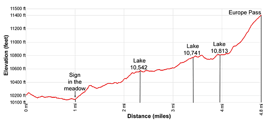
Distance: 4.8 - 6.0 miles (one way)
Bridger Wilderness, Bridger-Teton National Forest, near Big Sandy in Wyoming's Wind River Range
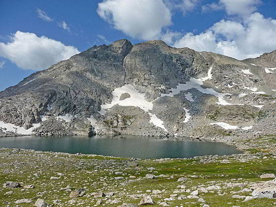
View of Lake 11,023 from the trail to Europe Pass
- Distance: 4.8 - 6.0 miles
- Elevation: 10,210-ft. at Junction Valley Lakes
10,542-ft. at Lake 10,542
10,741-ft. at Lake 10,741
10,813-ft. at Lake 10,813
11,459-ft. at Europe Pass - Difficulty: moderate-strenuous
- Basecamp: Big Sandy / Elkhart Park
- Region: Wyoming's Wind River Range
Europe Canyon and Pass Trail Description
This side trip visits pretty Valley Lake and then ascends through scenic Europe Canyon, a secluded valley featuring seven alpine lakes set amid rugged granite peaks. The hike ends at Europe Pass, a high saddle along the Continental Divide overlooking the Milky Lakes basin.
The unmarked junction of the Valley Lake trail to Europe Canyon is located along the north bound Fremont Trail, 0.2 miles to the northwest of the crossing of Pipestone Creek, the stream linking the two Pipestone Lakes. Bear right (north) at the junction to visit Valley Lake and Europe Canyon. The trail to the left (west/northwest) is the continuation of the Fremont Trail to North Fork Lake.
Note: There is a second trail to Valley Lake along the Fremont Trail, 0.8 miles beyond the Pipestone Creek crossing. This trail travels along the west side of Valley Lake. The first Valley Lake trail traverses the east and then north sides of the lake. The two trails meets above the north end of the lake.
From the first Valley Lake junction the trail ascends north on moderate grades through meadows, crossing a knoll scattered with remnants of burnt trees from the 1988 Fayette Fire. This is the northern most extent of the fire. A short distance beyond the knoll you will leave the last of the burnt trees behind.
Follow the trail as it descends from the knoll through meadows scattered with Lupines to a stream crossing at 0.2 miles. Look back to the southeast to see the head of the second Pipestone Lake. To the northeast views open to a few small ponds and Lake Prue (10,157-ft.), nestled in a tree-lined bowl beneath Medina Mountain (11,541-ft.).
Beyond the stream crossing the trail ascends a second knoll before dropping down to the southeast end of Valley Lake (10,147-ft.) at 0.6 miles. Take a side trip to the shoreline for great views of Victor Mountain (12,254-ft.) and the peaks towering above North Fork Canyon to the north/northwest respectively.
To the right (east) of the trail is a long, narrow unnamed lake. Nice campsites are located in the trees around the lakeshore.
The trail now traverses through meadows and clusters of trees along the east side of Valley Lake, passing a few small tarns. More camping is found amid the trees and rocky knolls above the lakeshore.
Near the north end of the lake the trail curves to the left (west) as it crosses a large meadow. At 1.0 mile start looking right (north) for a post with a wood sign, set well back from the trail, in the meadows. Cross the meadow to the sign which says, “Trail Abandoned, Not Maintained.” Beyond the sign you will see a narrow path heading northeast into the trees. This is the beginning of the Europe Canyon trail. The trail becomes clearer as you proceed.
If you reach the outlet stream at the north end of Valley Lake you have missed the Europe Canyon trail. Turn around and walk back along the Valley Lake trail, looking to your left (north/northeast) for the sign. A small rock cairn along the trail marks the junction but no trail is evident in the meadows until you reach the sign.
After finding the sign follow the Europe Canyon trail as it ascends on moderate grades through trees. Along the way pass a trail, branching to the right (east), that leads to a campsite.
At 1.3 miles the grade eases as the trail continues ascending on easy grades. Openings in the trees offer views of Mount Victor to the west and the peaks rising above Europe Canyon to the north.
Soon the trees give way to moist meadows clogged with willows. Pay attention to stay on the trail as it travels through the lush vegetation.
At 1.7 miles the trail turns to the right (east/southeast) and skirts the south side of a small lake, traveling through meadows and scattered trees. From the lakeshore enjoy more nice views of Mount Victor and the domes rising above Europe Canyon to the west/northwest.
Note: Old topo maps show a trail branching to the left (north), crossing the lake’s outlet stream and then dropping into Europe Canyon. This trail is hard to find and no longer used.
Beyond the east end of the lake the trail curves to the left (northeast) and crosses the lake’s inlet stream at 1.9 miles. Past the crossing the path climbs a rocky knoll. At 2.1 miles the grade abates as the trail travels along the west side of the outlet stream emanating from Lake 10,542. Here beautiful views open to the peaks surrounding Europe Canyon’s lower lake basin and beyond.
The trail now climbs on easy grades through meadows litter with boulders and rock outcroppings to the southwest shore of Lake 10,542 at 2.3 miles. Horseshoe Ridge (12,074-ft.) towers above the lake to the west. Scenic, albeit partially exposed, campsites are located among the rocky knobs and small trees to the northwest of the outlet stream.
Follow the trail as it skirts the west/northwest side of the lake. At 2.7 miles views open to a small lake to the north. Just past the northeast end of Lake 10,542 the trail enters a willow thicket and crosses a stream. As the trail exits the willows turn around to identify some landmarks to make sure you find the trail through the willows on the return trip down the canyon.
Past the crossing the grade steepens a bit as the path now travels up the floor of Europe Canyon, staying to the left (northwest) of the creek draining the canyon. During late July the meadows along this section of the trail are filled with wildflowers.
At 3.2 miles rock-hop across to the south side of the wide, shallow creek. (The route to Long Lake starts just before the creek crossing. See the description of this off-trail hike at the end of the page for more information.) Soon views open to Lake 10,741. The rugged slopes of Peak 12,120 tower above the lake’s northwestern shore. Horseshoe ridge dominates the view to the southeast. To the northeast are the peak and ridges defining the Continental Divide.
Reach the south end of Lake 10,741 at 3.4 miles. Here the trail curves to the left (north) and ascends through meadows beside a waterfall on the stream running between Lake 10,741 and Lake 10,813. A short, easy climbs leads to the west side of Lake 10,813, nestled in the rocky meadows beneath the Continental Divide, at 3.9 miles. Here the trail crosses the stream.
Beyond the crossing the path heads northeast, briefly traveling along the lakeshore before ascending above the lake. This section of the trail crosses a small rock slide and the channels of the braided outlet stream for Lake 11,023, our next destination. Dense clusters of wildflowers grow amid the streams channels. Pay attention to stay on course. The trail is easy to lose as it traverses the boggy terrain between the stream channels.
Soon the trail curves to the left (north) and climbs steeply up to the bench cradling Lake 11,023. The grade abates as you reach the bench at 4.2 miles. To the west are fine views of Europe Peak (12,259-ft.) and Peak 12,120 rising above the lake. To the north Europe Pass, the saddle on the ridge to the east of Europe Peak, is now in view.
To visit Lake 11,023 simply head west across the rocky meadows to the lakeshore. There is no trail to the lake.
To reach Europe Pass, continue along the trail heading north. The path is easy to lose as it climbs steeply through the meadows. If you lose the trail, aim for the edge of the talus slopes along the cliffs below the east side of the pass. Soon you should find a faint, boot beaten path climbing to the pass. If not, simple chart your own course up the meadows to the obvious saddle.
Arrive at Europe Pass (11,459-ft.) on the Continental Divide at 4.8 miles. As you crest the pass views open to the Milky Lakes nestled beneath the Milky Ridge in the Wind River Indian Reservation. In the distance to the northwest a sea of peaks tower above the Alpine Lakes and Indian Basin. To the south Horseshoe Ridge dominates the view. Below the pass to the south are fine views of Lake 11,023 and Lake 10,813.
A fishing permit from the Wind River Indian Reservation is required to cross the pass and drop into the Milky Lakes basin. When you are done taking in the views, retrace your steps to Valley Lake or your campsite in Europe Canyon.
Long Lake Trail
- Distance: 1.2 miles (round trip)
- Elevation: 10,710-ft. at Start Point for the Route
10,840-ft. at the Long Lake Overlook - Difficulty: moderately-strenuous
Beautiful Long Lake (10,683-ft.) lies nestled in a granite bowl between Mount Victor (12,254-ft.), to the west, and Peak 12,120, to the east. The lake can be reach either from Europe Canyon or a side valley branching off from North Fork Canyon. A short detour up a short, north trending side valley off Europe Canyon leads to a scenic overlook above the lake. The valley is located between Lake 10,542 and Lake 10,741.
There is no trail to the overlook, just a suggested route. To reach the overlook, turn left (northwest) off the Europe Canyon trail at 3.1 miles. This suggested exit point is located just before the Europe Canyon trail crosses to the south side of the creek on its way to Lake 10,741.
The route climb northwest through meadows littered with boulders and then contours along the slopes of a rocky hillside along the northeast slopes of the side valley. Pick your route to avoid marshy meadows in the center of the valley. After 0.3 miles you should reach a bench with a small pond to the west of Peak 12,120.
Continue the ascent along the northeast side of valley. You will be wandering through a landscape littered with boulders and rock outcroppings, passing a few small tarns along the way. Stay to the right (east) of the tarns. As you climb enjoy ever improving views of Mount Victor.
At 0.8 miles skirt the east side of a tarn and then climbs to the overlook, a high point on the rocky knob beyond the tarn. As you crest the knob Long Lake will spring into view. The stunningly beautiful elongated lake stretches for 0.8 miles beneath the rugged cliffs and slopes of Peak 12,120 to the east. Mount Victor towers above the lake to the west. In the distance views extend northwest to Fremont Peak.
During periods of low water it is possible to drop down to the lake and navigate a course along the east shore. Otherwise the route along the lake is quite difficult and requires climbing high above the east side of the lake to circumvent the steep cliffs along the lakeshore.
I personally recommend enjoying the views of Long Lake and then returning to the main Europe Canyon trail and continuing up the canyon to Lake 11,023 and Europe Pass.
Return to Segment 4: Sandpoint Lake to Valley Lake Junction
Go To Segment 5: Valley Lake Junction to North Fork Lake
Elevation Profile
Backpack Segments
- Introduction: Big Sandy to Elkhart Park via Fremont and Highline Trails
- Segment 1: Big Sandy to Marms Lake
- Segment 2: Marms Lake to Raid Lake
- --- Side Trip: Bonneville Lakes
- Segment 3: Raid Lake to Middle Fork Junction above Sandpoint Lake
- --- Side Trip: Middle Fork Lake Trail
- --- Side Trip: Middle Fork Lake via the Rainbow Lake Trail
- --- Side Trip: Photo Pass Trail
- Segment 4: Sandpoint Lake to Valley Lake Junction
- --- Side Trip: Europe Canyon and Pass
- Segment 5: Valley Lake Junction to North Fork Lake
- --- Side Trip: Hay Pass, the Golden Lakes and Fall Creek Pass
- Segment 6: North Fork Lake to Bell Lakes Junction
- Segment 7: Bell Lakes Junction to Pole Creek
- --- Side Trip: Cook and Wall Lakes
- Segment 8: Pole Creek to Little Seneca Lake
- Segment 9: Little Seneca Lake to Island Lake
- --- Side Trip: Titcomb Basin
- --- Side Trip: Indian Basin and Pass
- --- Side Trip: Island Lake Waterfall Hike
- Segment 10: Island Lake to Elkhart Park
Driving Directions to Big Sandy Trailhead
Big Sandy Trailhead: This popular trailhead is located in the southern Wind River Range next to the Big Sandy River.
Directions from Pinedale: From the intersection of Pine Street (US 191) and North Tyler Ave (the Pinedale Tourism office is located on the northeast corner) in Pinedale, WY, drive south on Highway 191 for 11.7 miles and then turn left (east) on WY-353. After 15.5 miles you will notice signs referring to the road as the Big Sandy-Elkhorn Road and after 18 miles the paved road will change to a good packed dirt/gravel surface.
Shortly after the pavement ends go straight through a junction, and drive south crossing the Big Sandy River (Buckskin Crossing). Follow the road for a total of 27.3 miles. Shortly after crossing the Big Sandy River you will reach a junction with the Lander Cutoff Road (the next junction). Turn left on the Lander Cutoff Road. There is a wood sign at the intersection pointing toward the Big Sandy trailhead.
Drive 7.0 miles on the Lander Cutoff Road and then turn left on the Big Sandy Opening Road. Here you will see a sign for the Big Sandy Campground and trailhead. The road now deteriorates and narrows. Blind corners and lush foliage along the road make it hard to see ahead. Drive carefully, following the rocky, rutted road for 9.8 miles to a "Y" intersection. Bear right at the intersection to continue along the Big Sandy Opening Road (Forest Service Road 850). (The road branching to the left leads to the Big Sandy Lodge and Mud Lake.) Follow the road for 0.8 miles to the trailhead parking area, equipped with an outhouse.
Allow an hour and a half to reach the trailhead from Pinedale. The parking area is too small for the number of backpackers visiting the area during the height of the summer. If the parking area is full, find a safe place to park off the access road.
I recommend a high clearance vehicle to reach the trailhead. Passenger cars can make it OK if driven carefully. Check at the Pinedale ranger station before starting your trip to learn about current road and trail conditions. The Ranger Station is located to the east of the Ridleys Grocery Store on US 191 (Pine Street in Pinedale). The entrance to the ranger station is on the Fremont Lake Road. (You can also reach the parking area for the ranger station by driving east through the Ridley’s parking lot.)
This trailhead is remote, so be sure to have a full tank of gas. The dirt road become slippery when wet. The campground at the parking area is tiny, with only 4 sites. I would not plan on camping at the trailhead before starting your backpack.
Elkhart Park Trailhead: From the intersection of Pine Street (US 191) and North Tyler Ave (the Pinedale Tourism office is located on the northeast corner) in Pinedale, WY, drive east on Highway 191 (East Pine Street) for 0.3 miles and bear left onto Fremont Lake Road. Follow this road for 14.3 miles and turn right into the large parking area for the Elkhart Park/Pole Creek Trailhead. After the first 3.0 miles the road will turn into Skyline Drive/Forest Service Road 370740. The trailhead is located at the northeast end of the parking lot between the outhouse and the trailhead kiosk. It should take about 25 minutes to drive the trailhead. The last section of the road has some holes and uneven spots.
Trail Resources
- Backpack Intro
- Segment Photo Gallery
- Segment Map
- Trailhead(s) Information: Big Sandy / Elkhart Park
- Region Information: Wyoming's Wind River Range
- Other Hiking Regions in: Wyoming