Backpack: Big Sandy to Elkhart Park via Fremont and Highline Trails
Segment 3: Raid Lake to Middle Fork Junction above Sandpoint
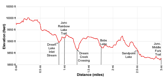
Distance: 3.0 miles (one way)
Bridger Wilderness, Bridger-Teton National Forest, near Big Sandy in Wyoming's Wind River Range

Rainbow Lake
- Distance: 3.0 miles
- Elevation: 9,970-ft. at South Fork Boulder Creek
9,910-ft. at Junction Rainbow Lake Trail
9,880-ft. at Dream Creek Crossing
9,880-ft. at Bobs Lake
9,846-ft. at Sandpoint Lake
9,828-ft. at Middle Fork Boulder Creek Crossing
9,850-ft. at Junction Middle Fork Trail - Difficulty: moderate
- Basecamp: Big Sandy
- Region: Wyoming's Wind River Range
Raid Lake to Middle Fork Junction above Sandpoint Description
From the crossing of the South Fork of Boulder Creek at the head of Raid Lake, the Fremont trail curves left (west) and ascends a low hill, passing the unmarked junction with the Bonneville Lake trail branching right (northeast). Beyond the junction the path skirts the north shore of a small pond and then reaches the top of the hill at 0.2 miles. Turn around for nice views of Ambush Peak (12,173-ft.), Raid Peak (12,532-ft.) and Mount Bonneville (12,585-ft.).
Descend from the hill, passing to the north of Raid Lake’s northwest arm and then follow the trail as it curves to the right (northwest). Soon views open to Dream Lake, nestled in the immense South Fork Meadows.
Follow the trail as it drops down to and crosses an inlet stream at Dream Lake’s eastern arm at 0.9 miles and then climbs on easy grades along the backside of a rocky knoll rising above Dream’s eastern shore. The knoll blocks the view of the lake.
As you ascend, pass a small pond along the left (west) side of the trail. Near the head of the pond reach a signed junction with the Rainbow Lake trail branching right (north) at 1.0 mile. The Rainbow Lake trail leads to the lake and an off-trail route to the head of Middle Fork Lake. We continue straight ahead on the Fremont Trail in the direction of Sandpoint Lake.
The trail passes two more ponds crosses a hill and descends toward the north end of the lake basin. Soon views reopen to Dream Lake (9,880-ft.). If you are looking for a campsite, leave the trail at this point and head south toward the lake. A few nice campsites are located in the trees on the hillside above the east side of the lake.
The trail now drops down to and crosses Dream Creek at 1.25 miles and then climbs a low hill, skirting the east side of an unnamed lake. Past the north end of the lake reach a junction with the Dream Lake trail heading left (west) through the South Fork meadows toward the Scab Creek trailhead. From this junction enjoy distance views of Halls Mountain (12,475-ft.), Horseshoe Ridge (12,128-ft.) and Mount Victor (12,254-ft.) rising to the north/northwest.
We continue straight ahead on the Fremont trail, which descends from the hill to reach the south end of Bobs Lake (9,865-ft.) at 1.75 miles. The trail now arcs around the lake’s eastern shore, reaching the north side of the lake at 2.0 miles. Look south for the last views of the vast South Fork Meadows.
The trail now climbs the hill to the north of the lake. Nice campsites are located in the trees atop the knoll to the west of the trail. More campsites are found in the forest hills above the lake’s eastern shore.
Soon the trail reaches the top of the hill and then descends on gentle grades into a small drainage. Climb out of the drainage, over a forested hill. As you descend the hill views open to Sandpoint Lake (9,810-ft.). At 2.5 miles the trail reaches its namesake sandy beach along the lake’s eastern shore.
Past the beach the trail follows an undulating course along the lake’s eastern shore. Campsites are located in the forested slopes above the west and east side of the lake.
At the north end of the lake the trail curves around a rocky knoll and reaches the Middle Fork of Boulder Creek at just under 3.0 miles. Wade the shin-deep river. Late in the season or during periods of low water you may be able to rock-hop across the channel.
Follow the trail upstream along the north side of the creek for a short distance to a trail junction at 3.0 miles. This intersection is easy to miss if you are not paying attention. Here the Fremont Trail branches to the left (northwest) while the Middle Fork trail curves to the right (northeast), following the Middle Fork creek upstream.
Return to Segment 2: Marms Lake to Raid Lake
Go To Segment 4: Sandpoint Lake to Valley Lake Junction
Elevation Profile
Backpack Segments
- Introduction: Big Sandy to Elkhart Park via Fremont and Highline Trails
- Segment 1: Big Sandy to Marms Lake
- Segment 2: Marms Lake to Raid Lake
- --- Side Trip: Bonneville Lakes
- Segment 3: Raid Lake to Middle Fork Junction above Sandpoint Lake
- --- Side Trip: Middle Fork Lake Trail
- --- Side Trip: Middle Fork Lake via the Rainbow Lake Trail
- --- Side Trip: Photo Pass Trail
- Segment 4: Sandpoint Lake to Valley Lake Junction
- --- Side Trip: Europe Canyon and Pass
- Segment 5: Valley Lake Junction to North Fork Lake
- --- Side Trip: Hay Pass, the Golden Lakes and Fall Creek Pass
- Segment 6: North Fork Lake to Bell Lakes Junction
- Segment 7: Bell Lakes Junction to Pole Creek
- --- Side Trip: Cook and Wall Lakes
- Segment 8: Pole Creek to Little Seneca Lake
- Segment 9: Little Seneca Lake to Island Lake
- --- Side Trip: Titcomb Basin
- --- Side Trip: Indian Basin and Pass
- --- Side Trip: Island Lake Waterfall Hike
- Segment 10: Island Lake to Elkhart Park
Driving Directions to Big Sandy Trailhead
Big Sandy Trailhead: This popular trailhead is located in the southern Wind River Range next to the Big Sandy River.
Directions from Pinedale: From the intersection of Pine Street (US 191) and North Tyler Ave (the Pinedale Tourism office is located on the northeast corner) in Pinedale, WY, drive south on Highway 191 for 11.7 miles and then turn left (east) on WY-353. After 15.5 miles you will notice signs referring to the road as the Big Sandy-Elkhorn Road and after 18 miles the paved road will change to a good packed dirt/gravel surface.
Shortly after the pavement ends go straight through a junction, and drive south crossing the Big Sandy River (Buckskin Crossing). Follow the road for a total of 27.3 miles. Shortly after crossing the Big Sandy River you will reach a junction with the Lander Cutoff Road (the next junction). Turn left on the Lander Cutoff Road. There is a wood sign at the intersection pointing toward the Big Sandy trailhead.
Drive 7.0 miles on the Lander Cutoff Road and then turn left on the Big Sandy Opening Road. Here you will see a sign for the Big Sandy Campground and trailhead. The road now deteriorates and narrows. Blind corners and lush foliage along the road make it hard to see ahead. Drive carefully, following the rocky, rutted road for 9.8 miles to a "Y" intersection. Bear right at the intersection to continue along the Big Sandy Opening Road (Forest Service Road 850). (The road branching to the left leads to the Big Sandy Lodge and Mud Lake.) Follow the road for 0.8 miles to the trailhead parking area, equipped with an outhouse.
Allow an hour and a half to reach the trailhead from Pinedale. The parking area is too small for the number of backpackers visiting the area during the height of the summer. If the parking area is full, find a safe place to park off the access road.
I recommend a high clearance vehicle to reach the trailhead. Passenger cars can make it OK if driven carefully. Check at the Pinedale ranger station before starting your trip to learn about current road and trail conditions. The Ranger Station is located to the east of the Ridleys Grocery Store on US 191 (Pine Street in Pinedale). The entrance to the ranger station is on the Fremont Lake Road. (You can also reach the parking area for the ranger station by driving east through the Ridley’s parking lot.)
This trailhead is remote, so be sure to have a full tank of gas. The dirt road become slippery when wet. The campground at the parking area is tiny, with only 4 sites. I would not plan on camping at the trailhead before starting your backpack.
Elkhart Park Trailhead: From the intersection of Pine Street (US 191) and North Tyler Ave (the Pinedale Tourism office is located on the northeast corner) in Pinedale, WY, drive east on Highway 191 (East Pine Street) for 0.3 miles and bear left onto Fremont Lake Road. Follow this road for 14.3 miles and turn right into the large parking area for the Elkhart Park/Pole Creek Trailhead. After the first 3.0 miles the road will turn into Skyline Drive/Forest Service Road 370740. The trailhead is located at the northeast end of the parking lot between the outhouse and the trailhead kiosk. It should take about 25 minutes to drive the trailhead. The last section of the road has some holes and uneven spots.
Trail Resources
- Backpack Intro
- Segment Photo Gallery
- Segment Map
- Trailhead(s) Information: Big Sandy
- Region Information: Wyoming's Wind River Range
- Other Hiking Regions in: Wyoming