Backpack: Big Sandy to Elkhart Park via Fremont and Highline Trails
Segment 6: North Fork to Bell Lakes Junction
Distance: 5.4 miles (one way)
Bridger Wilderness, Bridger-Teton National Forest, near Big Sandy in Wyoming's Wind River Range
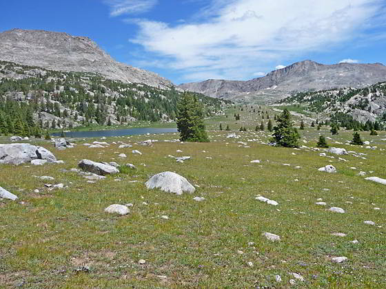
Looking up the Timico Valley
- Distance: 5.4 miles
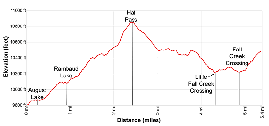
- Elevation: 9,785-ft. at Junction Hay Pass / Highline Trail
10,848-ft. at Hat Pass
10,225-ft. at Fall Creek Crossing
10,470-ft. at Junction Bell Lakes/Fremont Trail - Difficulty: strenuous
- Basecamp: Big Sandy / Elkhart Park
- Region: Wyoming's Wind River Range
North Fork to Bell Lakes Junction Description
This initial segment of this trail climbs to Hat Pass (10,848-ft.) through a pretty landscape of small lakes and ponds set amid forest and meadows, gaining 1,050-ft in 2.4 miles. The climb is generally on moderate grades with a few steep pitches.
This description starts at the signed four-way junction above the northwest corner of North Fork Lake. Here the Hay Pass trail, branching to the right (north), leads to Lake Victor and Hay Pass. The Highline trail to the left (south) heads to Lake Vera. We continue straight ahead (northwest) on the Fremont trail toward August Lake and Hat Pass.
Beyond the junction the trail ascends on moderate grades through trees to the south shore of August Lake (9,870-ft.). The grade abates as the trail swings around the southwest end of the lake and then wanders through meadows along the lake’s western shore.
At 0.4 miles the path crosses the inlet stream and then resumes its ascent up a draw through scattered trees, staying to the east of the stream. At 0.7 miles the trail breaks from the trees and then travels on easy grades through meadows along the eastern shore of Rambaud Lake (10,085-ft.).
At the head of the lake the trail turns north and then northeast, climbing through timber along the east side of a narrow draw channeling Rambaud Lake’s inlet stream. As the trail reaches a small meadow it crosses the inlet stream, swings to the left (west) and exits the draw at 1.2 miles.
The trail now ascends through trees on moderate grades and soon turns swings back to the right (north). As you climb the trees thins. Soon the forest gives way to meadows set amid rock outcroppings and scattered trees.
At 1.7 miles the grade eases as the trail passes the southwestern end of a small pond. This is a good place to get water before crossing Hat Pass. Past the pond the trail resumes its climb through scattered trees.
At 2.0 miles the path briefly travels along the east side of a small creek and then crosses to the west side. Here the grade eases as the trail reaches a small meadow littered with willow thickets at the base of Hat Pass. Follow the trail as it crosses the boggy meadows, keeping to the high ground between two small tarns.
The trail now starts a steep climb up a gully through rocky meadows and talus slopes beneath the west face of a low ridge. Soon the trail exits the gully and ascends steeply through rocky meadows to Hat Pass (10,848-ft.) at 2.4 miles.
From the pass views extend southeast to Raid Peak (12,532-ft.), Mount Bonneville (12,585-ft.) and Pronghorn Peak (12,388-ft.). On a clear day you should be able to pick out Temple Peak (12,972-ft.) in the distance. To the east a ridge of 11,000-ft peaks extending northwest from Peak 11747 fills the skyline.
Cross the broad pass for fine views to the northwest of Baldy Mountain (11,857-ft.) and the peaks rising along the east side of the Bell Lakes basin. When you are done taking in the views, descend on moderate to moderately steep grades down the north side of the pass, traveling through meadows littered with boulders and rock outcroppings, passing a small pond along the way. At 2.1 miles the grade eases as it crosses a creek. Beyond the creek the trail follows an undulating course that weaves its way through clusters of trees, meadows and small ponds.
After crossing a minor draw the trail climbs over a low rise at 3.8 miles and then descends on moderate grades through meadows and scattered trees set amid rocky knobs into the Little Fall Creek drainage.
Reach a crossing of Little Fall Creek at 4.4 miles. During the height of the summer the area around the creek is filled with wildflowers. Hop across the creek and then climb the hillside to the northwest to exit the drainage. Atop the hill the trail skirts the east side of marshy meadows, passing a few small ponds. Here views open to the peaks rising above the Timico Valley to the northeast.
Follow the trail as it climbs over another low rise and then descends into the beautiful Fall Creek valley. To the north enjoy fine views of the ridge rising to the north.
At 4.9 miles reach a trail junction near the east shore of Fall Creek. To the left (southwest) the Timico Lake Trail leads to Barnes Lake, located on the Highline trail to the south. The Fremont trail continues straight ahead and crosses Fall Creek. If the water is low, rock-hop across the creek, otherwise take off your boot and wade the shin-deep creek.
On the north side of the creek the trail turns right (northeast) and briefly travels along the west side of the valley floor. At 5.1 miles the path curves left (north/northwest) as it climbs on moderate grades up the north side of the valley to the large meadows at the foot of the Timico Valley. From the meadows enjoy fine views of Round Top Mountain (12,048-ft.) and the unnamed peaks towering above the valley. Near at hand, a small pond lies nestled in the meadows to the north.
Reach a trail junction at the northwest end of the meadows at 5.4 miles. Here the Fremont Trail continues straight ahead (northwest) toward the Cook Lakes. To the left (west) is the Bell Lakes trail which leads to the Baldy Lakes Trail and the Chain Lakes, located along the Highline trail. To the right (northeast) the Timico Lakes Trail heads across the meadows to Timico Lake (10,512-ft.). This trail is initially hard to follow as it descends through the meadows to cross the outlet stream for the pond. Beyond the outlet stream the path becomes better defined as it ascends the valley to the lake. The one-mile (one-way) detour to the lake offers secluded, albeit exposed, campsites near the lake’s outlet stream and good fishing.
Return to Segment 5: Valley Lake Junction to North Fork Lake
Go To Segment 7: Bell Lakes Junction to Pole Creek
Elevation Profile
Backpack Segments
- Introduction: Big Sandy to Elkhart Park via Fremont and Highline Trails
- Segment 1: Big Sandy to Marms Lake
- Segment 2: Marms Lake to Raid Lake
- --- Side Trip: Bonneville Lakes
- Segment 3: Raid Lake to Middle Fork Junction above Sandpoint Lake
- --- Side Trip: Middle Fork Lake Trail
- --- Side Trip: Middle Fork Lake via the Rainbow Lake Trail
- --- Side Trip: Photo Pass Trail
- Segment 4: Sandpoint Lake to Valley Lake Junction
- --- Side Trip: Europe Canyon and Pass
- Segment 5: Valley Lake Junction to North Fork Lake
- --- Side Trip: Hay Pass, the Golden Lakes and Fall Creek Pass
- Segment 6: North Fork Lake to Bell Lakes Junction
- Segment 7: Bell Lakes Junction to Pole Creek
- --- Side Trip: Cook and Wall Lakes
- Segment 8: Pole Creek to Little Seneca Lake
- Segment 9: Little Seneca Lake to Island Lake
- --- Side Trip: Titcomb Basin
- --- Side Trip: Indian Basin and Pass
- --- Side Trip: Island Lake Waterfall Hike
- Segment 10: Island Lake to Elkhart Park
Driving Directions to Big Sandy Trailhead
Big Sandy Trailhead: This popular trailhead is located in the southern Wind River Range next to the Big Sandy River.
Directions from Pinedale: From the intersection of Pine Street (US 191) and North Tyler Ave (the Pinedale Tourism office is located on the northeast corner) in Pinedale, WY, drive south on Highway 191 for 11.7 miles and then turn left (east) on WY-353. After 15.5 miles you will notice signs referring to the road as the Big Sandy-Elkhorn Road and after 18 miles the paved road will change to a good packed dirt/gravel surface.
Shortly after the pavement ends go straight through a junction, and drive south crossing the Big Sandy River (Buckskin Crossing). Follow the road for a total of 27.3 miles. Shortly after crossing the Big Sandy River you will reach a junction with the Lander Cutoff Road (the next junction). Turn left on the Lander Cutoff Road. There is a wood sign at the intersection pointing toward the Big Sandy trailhead.
Drive 7.0 miles on the Lander Cutoff Road and then turn left on the Big Sandy Opening Road. Here you will see a sign for the Big Sandy Campground and trailhead. The road now deteriorates and narrows. Blind corners and lush foliage along the road make it hard to see ahead. Drive carefully, following the rocky, rutted road for 9.8 miles to a "Y" intersection. Bear right at the intersection to continue along the Big Sandy Opening Road (Forest Service Road 850). (The road branching to the left leads to the Big Sandy Lodge and Mud Lake.) Follow the road for 0.8 miles to the trailhead parking area, equipped with an outhouse.
Allow an hour and a half to reach the trailhead from Pinedale. The parking area is too small for the number of backpackers visiting the area during the height of the summer. If the parking area is full, find a safe place to park off the access road.
I recommend a high clearance vehicle to reach the trailhead. Passenger cars can make it OK if driven carefully. Check at the Pinedale ranger station before starting your trip to learn about current road and trail conditions. The Ranger Station is located to the east of the Ridleys Grocery Store on US 191 (Pine Street in Pinedale). The entrance to the ranger station is on the Fremont Lake Road. (You can also reach the parking area for the ranger station by driving east through the Ridley’s parking lot.)
This trailhead is remote, so be sure to have a full tank of gas. The dirt road become slippery when wet. The campground at the parking area is tiny, with only 4 sites. I would not plan on camping at the trailhead before starting your backpack.
Elkhart Park Trailhead: From the intersection of Pine Street (US 191) and North Tyler Ave (the Pinedale Tourism office is located on the northeast corner) in Pinedale, WY, drive east on Highway 191 (East Pine Street) for 0.3 miles and bear left onto Fremont Lake Road. Follow this road for 14.3 miles and turn right into the large parking area for the Elkhart Park/Pole Creek Trailhead. After the first 3.0 miles the road will turn into Skyline Drive/Forest Service Road 370740. The trailhead is located at the northeast end of the parking lot between the outhouse and the trailhead kiosk. It should take about 25 minutes to drive the trailhead. The last section of the road has some holes and uneven spots.
Trail Resources
- Backpack Intro
- Segment Photo Gallery
- Segment Map
- Trailhead(s) Information: Big Sandy / Elkhart Park
- Region Information: Wyoming's Wind River Range
- Other Hiking Regions in: Wyoming