Backpack: Big Sandy to Elkhart Park via Fremont and Highline Trails
Side Trip: Middle Fork Lake Trail
Distance: 3.5 - 6.0 miles (one way)
Bridger Wilderness, Bridger-Teton National Forest, near Big Sandy in Wyoming's Wind River Range
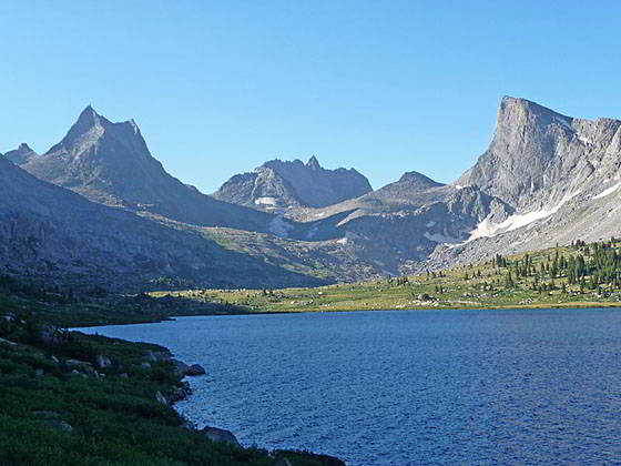
View of the cirque from Middle Fork Lake
- Distance: 3.5 - 6.0 miles
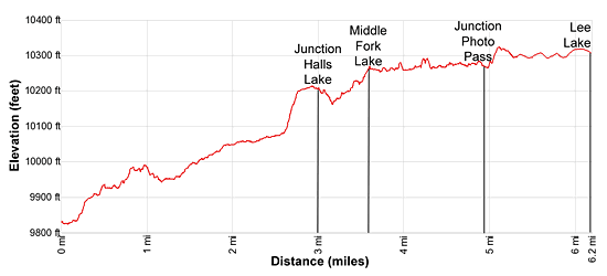
- Elevation: 9,846-ft. at Sandpoint Lake
9,828-ft. at Middle Fork Boulder Creek Crossing
9,850-ft. at Junction Middle Fork Trail
10,252-ft. at Middle Fork Lake
10,305-ft. at Lee Lake - Difficulty: moderate
- Basecamp: Big Sandy / Elkhart Park
- Region: Wyoming's Wind River Range
Middle Fork Lake Trail Description
From the northbound Fremont Trail, the Middle Fork Trail starts on the west side of the Middle Fork of Boulder Creek, about 0.15 miles past the northeast end of Sandpoint Lake. This trail can be combined with what the author calls the Rainbow Lake Trail to form a scenic loop. The junction of the Rainbow Lake trail with the Fremont Trail is to the northeast of Dream Lake. This path ascends to Rainbow Lake and then a saddle on the divide overlooking the Middle Fork Lake Basin. From the divide a route (no trail) descends to the head of Middle Fork Lake.
From the Junction with the Fremont Trail, the Middle Fork trail parallels the west side of the Middle Fork of Boulder Creek for a short distance before heading northeast away from the creek to cut off a long meander on the stream.
Follow the trail as it ascends on easy grades through spruce-pine forest and meadows, passing small ponds along the way. At 0.8 miles the trail crosses a knoll and then drops down to the northwest side of the creek at 1.0 mile. For the next 1.3 miles the trail travels through meadows with scattered trees along the northwest side of the creek. To the north are nice views of Halls Mountain (12,475-ft.) and the peaks ringing the Halls Lake basin.
At 2.1 miles the trail reaches the northwest end of a small lake (10,048-ft.) on the Middle Fork of Boulder Creek. Here views stretch east/northeast to Odyssey (12,062-ft.) and Kagevah (12,127-ft.) peaks rising along the Continental Divide. Dragon Head Peak (12,295-ft.) dominates the view to the east. The path now travels through willow-thickets and meadows for a 0.25 miles before climbing moderately steep grades up a knoll, gaining about 150-ft. Atop the knoll are two small ponds.
Soon the trail drops off the knoll and passes a junction with the route to Halls Lake at 3.0 miles. Despite the sign, there is no trail to Halls Lake (10,602-ft.), located to the northwest. Hikers wishing to visit the lake should obtain a topo map and then plot a route to the lake. With a map, reaching Halls Lake is not difficult for parties versed in off-trail travel.
The path now descends to and crosses a tributary creek before continuing its ascent, paralleling the north side of the Middle Fork of Boulder Creek. Along the way views open to Lake 10,100-ft. to the south of the trail.
At 3.5 miles the trail crests a small rise and Middle Fork Lake (10,252-ft.) springs into view. Views are somewhat restricted from the foot of the massive 240-acre boomerang-shaped lake. To the east to top of Dragon Head Peak rises above Peak 11,176. Kagevah Peak towers above the ridge along the Continental Divide to the northeast.
Campsites are located amid the trees and rocky knolls above the northwestern shore and in the area around the outlet stream. This is a popular camping area where horse packers and backpackers setup basecamps to fish and explore the surrounding area.
To Photo Pass and Lee Lake
To reach the head of Middle Fork Lake, the Photographer’s Pass Trail and Lee Lake, follow the undulating trail along the north side of the lake. After about a mile the trail starts curving to the southeast. Along the way enjoy ever improving views of the incredible cirque at the head of the valley. Bailey Peak (12,166-ft.) and the jagged horns of Nylon Peak (12,392-ft.) and the Twin Lions anchor the east side of the cirque while Dragon Head and Pronghorn Peak (12,398-ft.) rise to the west. Mt. Bonneville’s (12,585-ft.) serrated summit towers beyond the cirque to the south.
Cross the outlet stream for Bewmark Lake at 4.8 miles. The lake is located atop a bench above the north side of Middle Fork Lake. A short distance beyond the stream is the trail to Photo Pass, branching left (north). Soon the Middle Fork trail curves to the south and climbs above the east side of the lake to avoid rock outcroppings and marshy, willow choked meadows along the lakeshore.
Reach at the head of Middle Fork Lake at 5.4 miles. From this vantage point enjoy terrific views of the cirque at the head of the valley and high peaks rising around the Photo Pass area to the north.
The best bet to find a scenic campsite that offers some protection is to look in the trees above the southwest end of the lake or amid the scattered trees and rocky knolls around the inlet stream. Note: Large areas around head of the lake are quite boggy and infested with mosquitos early in the season.
To reach Lee Lake (10305-ft.), an azure gem nestled in the meadows near the head of the cirque, follow the boot beaten path along the east side of the inlet stream for 0.6 miles. Lee Lake features panoramic views of the high peaks surrounding the cirque. Exposed campsite sites around lake offer amazing views but are not a good place to be during a storm.
Return to Segment 3: Raid Lake to Middle Fork Junction above Sandpoint Lake
Go To Segment 4: Sandpoint Lake to Valley Lake Junction
Elevation Profile
Backpack Segments
- Introduction: Big Sandy to Elkhart Park via Fremont and Highline Trails
- Segment 1: Big Sandy to Marms Lake
- Segment 2: Marms Lake to Raid Lake
- --- Side Trip: Bonneville Lakes
- Segment 3: Raid Lake to Middle Fork Junction above Sandpoint Lake
- --- Side Trip: Middle Fork Lake Trail
- --- Side Trip: Middle Fork Lake via the Rainbow Lake Trail
- --- Side Trip: Photo Pass Trail
- Segment 4: Sandpoint Lake to Valley Lake Junction
- --- Side Trip: Europe Canyon and Pass
- Segment 5: Valley Lake Junction to North Fork Lake
- --- Side Trip: Hay Pass, the Golden Lakes and Fall Creek Pass
- Segment 6: North Fork Lake to Bell Lakes Junction
- Segment 7: Bell Lakes Junction to Pole Creek
- --- Side Trip: Cook and Wall Lakes
- Segment 8: Pole Creek to Little Seneca Lake
- Segment 9: Little Seneca Lake to Island Lake
- --- Side Trip: Titcomb Basin
- --- Side Trip: Indian Basin and Pass
- --- Side Trip: Island Lake Waterfall Hike
- Segment 10: Island Lake to Elkhart Park
Driving Directions to Big Sandy Trailhead
Big Sandy Trailhead: This popular trailhead is located in the southern Wind River Range next to the Big Sandy River.
Directions from Pinedale: From the intersection of Pine Street (US 191) and North Tyler Ave (the Pinedale Tourism office is located on the northeast corner) in Pinedale, WY, drive south on Highway 191 for 11.7 miles and then turn left (east) on WY-353. After 15.5 miles you will notice signs referring to the road as the Big Sandy-Elkhorn Road and after 18 miles the paved road will change to a good packed dirt/gravel surface.
Shortly after the pavement ends go straight through a junction, and drive south crossing the Big Sandy River (Buckskin Crossing). Follow the road for a total of 27.3 miles. Shortly after crossing the Big Sandy River you will reach a junction with the Lander Cutoff Road (the next junction). Turn left on the Lander Cutoff Road. There is a wood sign at the intersection pointing toward the Big Sandy trailhead.
Drive 7.0 miles on the Lander Cutoff Road and then turn left on the Big Sandy Opening Road. Here you will see a sign for the Big Sandy Campground and trailhead. The road now deteriorates and narrows. Blind corners and lush foliage along the road make it hard to see ahead. Drive carefully, following the rocky, rutted road for 9.8 miles to a "Y" intersection. Bear right at the intersection to continue along the Big Sandy Opening Road (Forest Service Road 850). (The road branching to the left leads to the Big Sandy Lodge and Mud Lake.) Follow the road for 0.8 miles to the trailhead parking area, equipped with an outhouse.
Allow an hour and a half to reach the trailhead from Pinedale. The parking area is too small for the number of backpackers visiting the area during the height of the summer. If the parking area is full, find a safe place to park off the access road.
I recommend a high clearance vehicle to reach the trailhead. Passenger cars can make it OK if driven carefully. Check at the Pinedale ranger station before starting your trip to learn about current road and trail conditions. The Ranger Station is located to the east of the Ridleys Grocery Store on US 191 (Pine Street in Pinedale). The entrance to the ranger station is on the Fremont Lake Road. (You can also reach the parking area for the ranger station by driving east through the Ridley’s parking lot.)
This trailhead is remote, so be sure to have a full tank of gas. The dirt road become slippery when wet. The campground at the parking area is tiny, with only 4 sites. I would not plan on camping at the trailhead before starting your backpack.
Elkhart Park Trailhead: From the intersection of Pine Street (US 191) and North Tyler Ave (the Pinedale Tourism office is located on the northeast corner) in Pinedale, WY, drive east on Highway 191 (East Pine Street) for 0.3 miles and bear left onto Fremont Lake Road. Follow this road for 14.3 miles and turn right into the large parking area for the Elkhart Park/Pole Creek Trailhead. After the first 3.0 miles the road will turn into Skyline Drive/Forest Service Road 370740. The trailhead is located at the northeast end of the parking lot between the outhouse and the trailhead kiosk. It should take about 25 minutes to drive the trailhead. The last section of the road has some holes and uneven spots.
Trail Resources
- Backpack Intro
- Segment Photo Gallery
- Segment Map
- Trailhead(s) Information: Big Sandy / Elkhart Park
- Region Information: Wyoming's Wind River Range
- Other Hiking Regions in: Wyoming